Northern NH road trip: Stark to Third Connecticut Lake

Great North Woods, New Hampshire (NHDOT map)

Great North Woods, New Hampshire (NHDOT map)

With no formal vacation in sight, I can improvise. Just give me 24 hours and a car. Good hiking territory is essential, but so is a pleasant drive. Earlier this week, that meant heading up I-93 to Coos County.

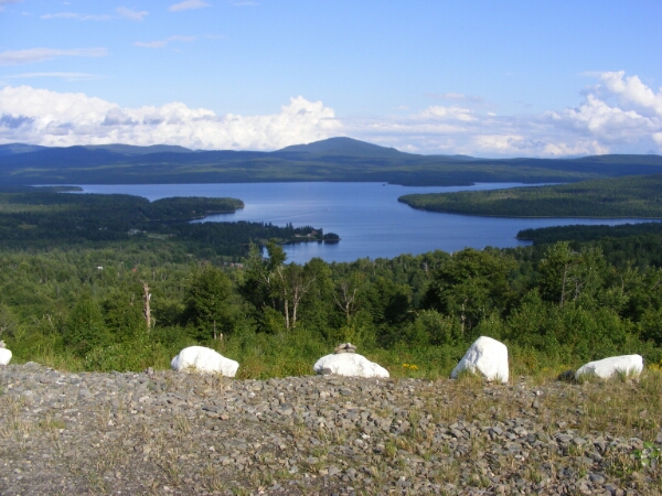
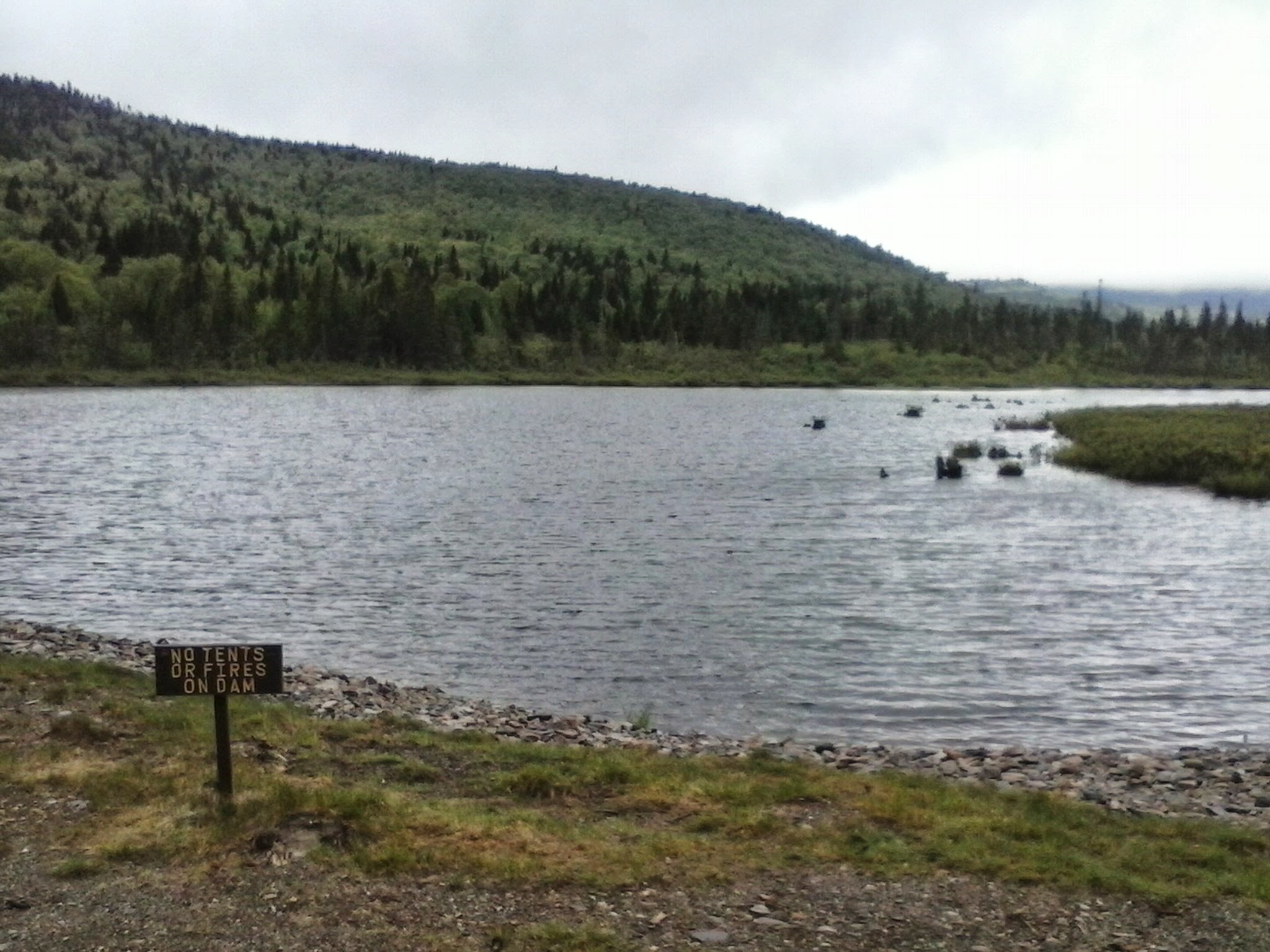
Third Connecticut Lake area
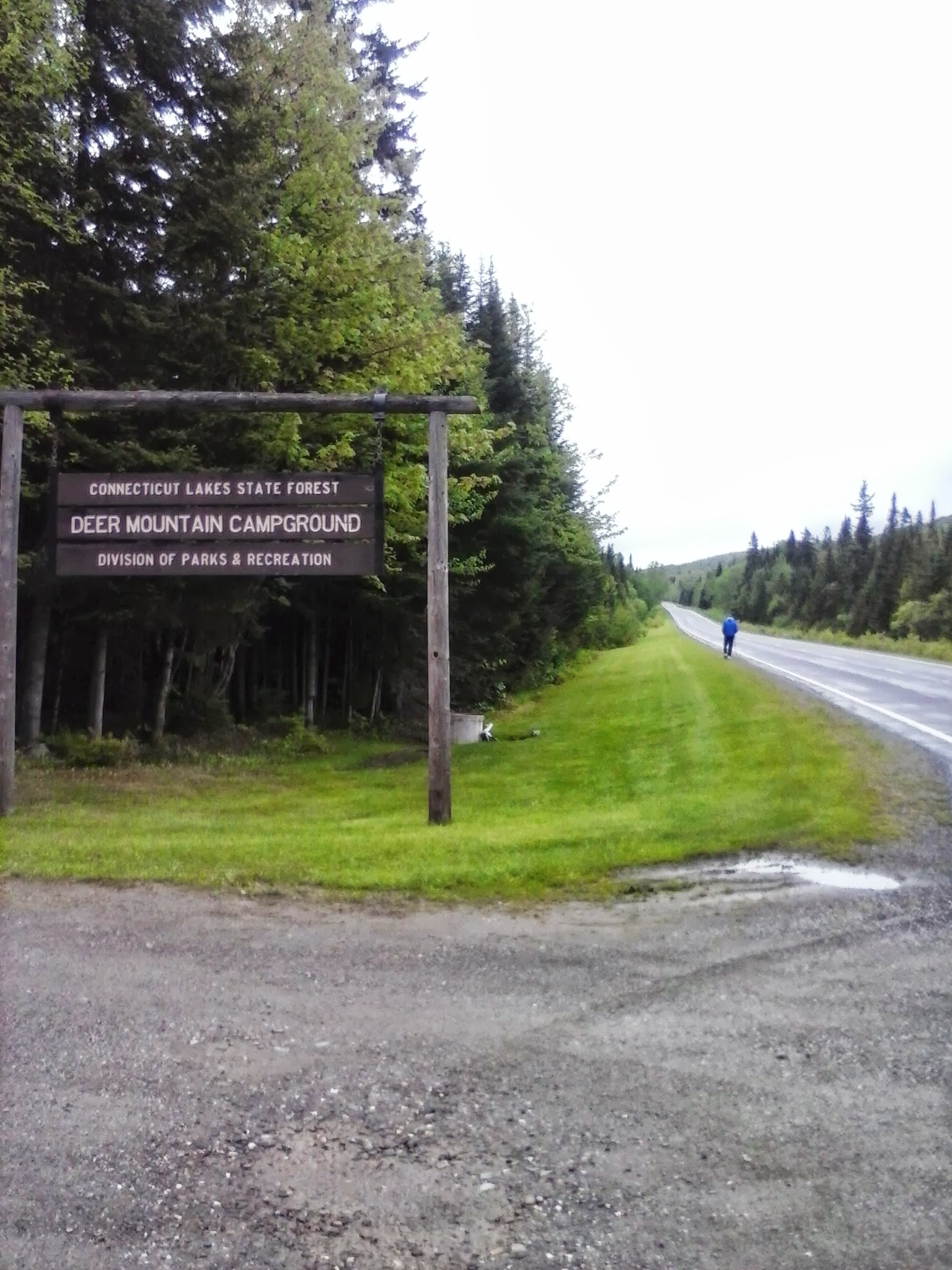
Lone hiker, five miles from Canada

Lone hiker, five miles from Canada

Site 28 at Deer Mountain State Park

Site 28 at Deer Mountain State Park

This trip was actually inspired by a planned work project on the Cohos Trail, cutting a spur to the summit of Deer Mountain in the town of Pittsburg near the Canadian border. Unfavorable weather forced postponement of the trail work, leaving me free to wander familiar trails alone for a few hours. Very quiet overcast morning: no logging in the area this week, only two campsites occupied at Deer Mountain State Park, only one other hiker in sight. No hills on this trip, given my limited time in the area. U.S. Rt. 3 was nearly deserted. Snowmobile trail #5, on which the Cohos Trail piggybacks in this area, had a few mud puddles, but nothing dramatic. I enjoyed miles of walking the highway and the trail.

When I hiked through this area on a backpacking trip in ’09, the segment of trail now shared with the snowmobile trail was not yet on line. I was on pavement in 90 degree weather from Happy Corner to the Canadian border. I loved that trip, but I can tell you that cool drizzle is fine, too.

Stark

OK, I’m cheating here: I didn’t hike in Stark. I broke up the long drive to Pittsburg by stopping for a night at the Stark Village Inn, owned and operated by a member of the Cohos Trail Association board. The inn is homey and affordable, and I would recommend it to anyone heading up that way who wants a comfortable place to stay without breaking the bank. Nancy, the owner, is the soul of hospitality. She can tell you about trails in the area, and she’s been known to provide shuttle service to local trailheads.

View from Stark Village Inn

View from Stark Village Inn

If I did decide to hike here, I’d probably head up the Nash Stream Road from NH Rt. 110. Or maybe I’d head south of 110 toward the Kilkenney Ridge trail. Maybe I’d just walk along 110 and enjoy the sound and sight of the Upper Ammonoosuc River. I’d turn off my cell phone, too. North of Lancaster, cell service ranges from spotty to nonexistent. That sort of enforces a vacation state of mind.

Etc.

I like Colebrook. It’s bustling, but it’s a tiny town nonetheless. Here, U.S. 3 meets NH 26, which leads to Dixville Notch. Another day, I would have gone to the Notch for a short but lung-busting climb to Table Rock. No time on this trip, though. “Later,” I promised silently as I drove past NH 26, not weakening even when I drove past Le Rendez-Vous. That’s a bakery with amazing stuff, including a chocolate croissant that will fortify any hiker.

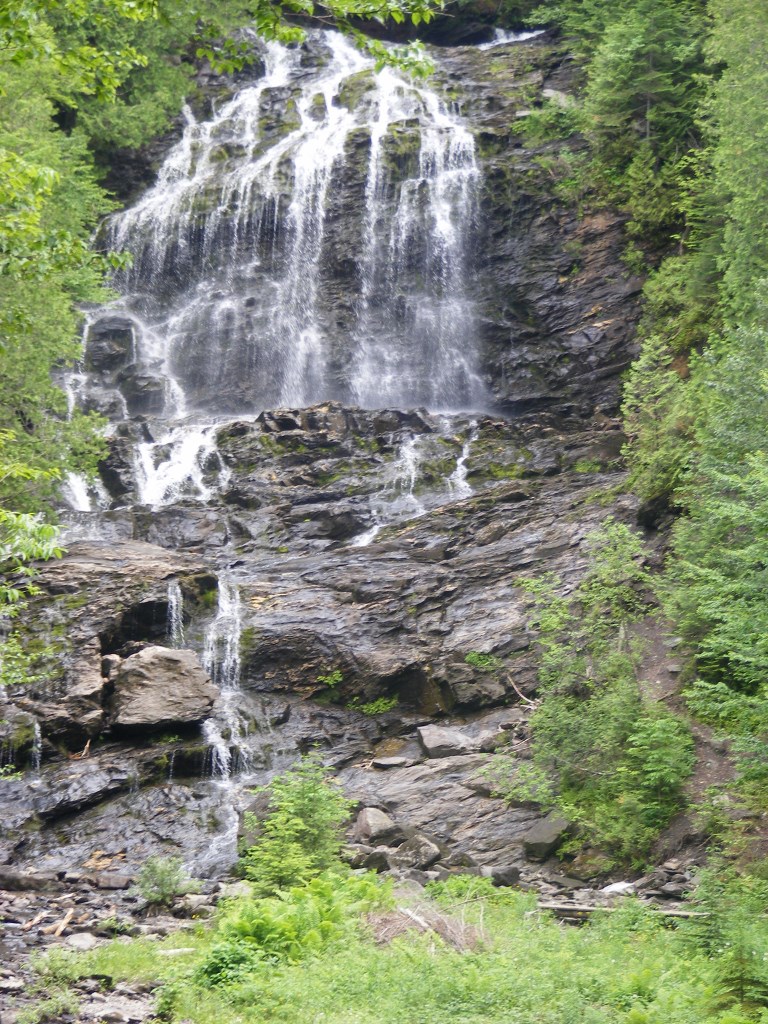
On NH 145 northeast of the center of town – a fun road, by the way – is Beaver Brook wayside area. Even if you’re driving past on your way to another trail, stop here. It’s a feast for the eyes. There are short trails near the falls, especially nice in the summer when the spray from the falls is soothing on hot days. Pack a picnic.

Beaver Brook wayside area

Beaver Brook wayside area

I stopped in Columbia on my way home, just south of Colebrook, at the Shrine of Our Lady of Grace. It doesn’t take long to walk the grounds. There are days when the shrine is thronged with pilgrims & tourists. I was there a few years ago during the Blessing of the Motorcycles (coming up this year on June 22), with hundreds of cheerful bilingual bikers. This week, I was alone. Different feeling altogether. For me, it was a place of prayer.

(Update: the Shrine closed in 2014. Part of the property has become the Tillotson Center, a community heritage, visual, and performing arts center.)

Shrine of Our Lady of Grace

Shrine of Our Lady of Grace

The ride back to southern New Hampshire on U.S. 3 goes past some of my favorite hiking spots, including Weeks State Park. There was that pesky clock ticking, though. I had some fun getting off U.S. 3 and I-93 in some areas to enjoy the back roads. I carry a DeLorme atlas (old school, I know, in these days of GPS) to give me inspiration when I’m all Interstated-out.

Of course, once I was halfway home, the sun came out and the temperature went up 15 degrees. If I couldn’t have that weather for hiking, it was at least nice to have it for driving. No complaints, though. Those were twenty-four pretty good hours.

Last Day on the Road

Last Day on the RoadAfter seven hot hours, I made it from Pittsburg village to Sportman’s Lodge. It was much more comfortable, not to mention faster, to be walking without a tent or pad or several days’ worth of food.

I slept like a baby last night. No matter how I try, there’s just no way I feel as secure in a tent as I do in a place like a cabin with a lock on the door.

I decided to spend some of my fast-dwindling cash supply on a really, really good breakfast. I went to Dube’s Pittstop (yes, an extra T), where the lone waitress was cheerfully attending to a nearly-full house. I ordered my plateful of food along with coffee & OJ, and then heard a cheerful greeting from the next table. I looked over and there was Armand, sitting with 5 or 6 buddies over coffee. A small town, indeed.

When I finished up, I bought a couple of bottles of some kind of flavored non-carbonated water-type stuff (couldn’t they just carry Gatorade??). Armand called out “May it all be downhill.” Surely, there’s no finer farewell for a hiker! We were laughing as I stepped outside for the last leg of the trip.

I took Rt. 145, & when I got to Clarksville Pond Rd., I took one look down Old County Road & decided to stay on 145 until Creampoke Road. When I got to the 45th Parallel marker, I hung my hat on its corner and propped my pack & trekking pole against the sign’s support pole & then took a picture. It occurred to me then that I should have been using that hat as a photographic prop throughout the trip.

145 climbs a bit leaving Pittsburg and heading through Clarksville. I cheered when I got to the little signs warning trucks to use low gear, knowing that meant a downhill stretch was coming up. On Creampoke Road’s long eastward run, a truck slowed down beside me & the driver said “Didn’t I see you in Pittsburg this morning?” Darned if it wasn’t one of Armand’s breakfast companions! We went our separate ways after a brief cheerful chat.

I packed 40 ounces of drinks & should have packed more. I packed 3 energy bars, & I could have done with one. Solid food seemed an unnecessary distraction.

After turning from Creampoke to Haines Hill Road which becomes McAllaster, I came to a fork that puzzled me. There was a logging cut on the left with a path through it, and a path like a snowmobile trail off to the right. I remembered going past a logged area when I came up here, but I hadn’t seen the fork from that direction. I used the 10-minute rule that has served me well on the trip, and I didn’t even need the full 10. About 3 minutes of walking into the log yard showed me a dead end on a little knoll.

Suddenly, I heard my phone buzzing. That little hill brought me into cell range, probably pinging off a Canadian tower. I was receiving a text my daughter had sent the night before. I texted her back with an update on my location.

Out of the logging yard, onto the other path, out of cell range: right back where I belonged. My compass confirmed I was heading SSW, close enough to south to be reassuring. The path gradually widened. I came around a curve and saw a massive tree down across the road. Suddenly, I remembered the tree from my northbound walk, and I knew where I was. The tree had been leaning over the road quite precariously when I last saw it. Once past the tree, I recognized the farm ahead, and soon I reached Bear Rock Road. The route was a piece of cake from there, with nothing ahead but signed town roads. By the time I got to Diamond Pond Road, I was dragging, but I knew I was almost done.

Coleman State Park at last! It was just a mile away from my goal, and I was more than ready for water when I got there. The park was deserted except for me and a lone motorcyclist. I dropped my pack & trekking pole on a picnic table & made a beeline for the nearest faucet. I filled my bottle & drank it straight down, savoring shade & water. A faint cell signal let me text my family that I was nearly done. My daughter sent a joyous message back a few moments later. In the patchy world of cell phone service in Coos County, there’s a faint signal at Coleman and no signal at all at the lodge a mile away.

Twenty minutes later, I was at Sportsman’s Lodge. I let Roger know I was back, told him I needed no dinner service, and went straight upstairs for a shower, clean clothes, and some rest. I felt utterly exhilarated.

We’ve had a good evening here, watching the Sox game. Linda and Roger treated me like an honored guest. Corey, a neighbor whom I met at last year’s CT gathering, greeted me like an old friend & wanted to hear about the hike. We all chatted, criticized our pitcher (Buchholz tonight), & put up with dogs & cats vying for attention. I called it a night after 5 or 6 innings, as did Corey.

My inventory of bodily damage from this escapade actually amounts to a short list.
Blisters: healing.
Toes: A few discolored toenails. Nothing I haven’t seen before.
Sunburn: during one stop along the way today, I was alarmed to see little blisters in patches on my shins. I’ve got sunburn over sunburn. I didn’t bother with sunscreen today because I figured I’d only sweat it off within the hour. I now have a painful reminder to USE it hourly, if necessary. I intend to lecture my kids about this. (They’ll ignore me. At their age, I didn’t want to hear it, either.)
Left knee: An arthritic joint, to be sure, now sore to the point where I need a pillow under it when I lie down. Nothing new. Naproxen & rest will help.

Tomorrow: laundry, reading, review my photos, and maybe do some kayaking (with lots of sunscreen) on Big Diamond Pond. The day after that, my husband will be here to pick me up and get his first look at the area.

Let’s see: 17 to 19 miles for today, depending on the relative accuracy of Google Maps & my own calculations. Actual one-way CT mileage from lodge to border, including spurs to lodging, & including 2 miles between Coleman SP & Tumble Dick Notch, comes to 51 miles. That excludes the work on the trails with Lainie, since it was road walking on US 3 that got me to the border. These calculations are for the benefit of all those people in my life who will only want to know how far – how many – how long. It all amounts to 85 miles altogether in 8 days of walking, if anyone asks.

It’s been three years from idea to fruition for this trip. From here, right now, it seems that it all went by in a flash.

My First Old Home Day

2013 update: Pittburg’s Old Home Day had nothing to do with the trail. The festival’s date, right in the middle of my trip, made the celebration too tempting to pass up. This was great fun.

 My First Old Home DayI’m very happy I made a point of being in town for Old Home Day, even though it extended my stay at the Bungalow. My dad used to say that fish & company stink after 3 days, and I’ve been here for four & a half.

Pete got a call just a few days ago, requesting that he march with the North Country Community Band in the parade. Thus I learned that he plays cornet – and not badly, either. He said he didn’t play often nowadays. But there he was in the parade, with about 20 other musicians. It takes people from 4 or 5 towns to make up this little band.

Floats abounded, many of them pulled by tractors. There was that Pittsburg HS baseball team, waving to the crowd & tossing candy to the kids. Sign on their float: “We told you we’d be back.” Loved it. There were one or two politically-themed floats; let’s just say this isn’t Obama country. Beecher Falls & Colebrook sent fire trucks to augment Pittsburg’s little contingent. They were all noisy & flashy, as fire trucks in a parade should be.

I think the entire town (population 800) came out, along with plenty of folks from neighboring towns. Pittsburg’s 4th of July festivities were rained out, I heard, and everyone seemed determined to make up for that.

After the parade, the town green was filled with tents & booths & food & games. I had a pulled-pork meal at one of the tents, and every bite was a tribute to God’s providence (so THAT’S what pigs are for!) — even the cole slaw, of which I’m not usually a fan. I had to check out the book sale table. It had maybe 50 books, most of them romances. Nope. I had better luck at the bake sale table, where I found brownies nearly as good as my son’s, and his are awesome.

I walked to the south end of Main Street to photograph the last of the town’s 3 covered bridges. I stopped at Robie’s Cabins to confirm my reservation for Tuesday night, & the proprietors, Mr. & Mrs. Dion, showed me where I’d be staying. Amazing day, and a fascinating look at a town very different from my own. I’d never have had this without the Cohos Trail.

Except for my breakfast & my water bottle, I’ve packed everything to move on to Deer Mountain SP in the morning. Tomorrow will be the last day with a full pack. I’ll leave the park on Tuesday, with a shuttle ride to the village. On Wednesday, I’ll mail home my tent & pad. Goodbye, dead weight.

Now, it’s back to the village for fireworks at Murphy Dam to cap off the day.

East Inlet

2013 update: I’m sorry that Armand, the wonderful guide who accompanied me on the East Inlet expedition, is no longer in the guide business. 

East InletMy bungalow room is 85º, if the thermometer on the wall is to be believed. I’m sitting in what is more or less the living room, kitchen windows open, table fan blowing at top speed. I packed for cooler weather. We’re getting 90º days & mid-60º nights. Dew point? Hanged if I know. Sticky weather for sure, and the details are irrelevant. It looks like I have only two nights in my tent coming up. If rain holds off, conditions will be fine.

I am nursing sunburned legs after an unforgettable kayak trip. About me & kayaks: I don’t own one. I rent or borrow one on rare occasions, for use on some nice flat body of water. I avoid embarrassment only by traveling alone. Today, I put aside my reluctance to look like a fool, just because I wanted to see East Inlet from the water, not from a few glimpses off East Inlet Road.

At the East Inlet Road boat launch, Pete, Lainie, & I put ourselves in Armand’s capable hands. An easygoing man with a dry wit, Armand knows this area well. He brought a kayak for each of us, so no one was subjected to tandem-kayaking with me. My last experience with a kayak was a few months back when my son and I rented a tandem kayak at Silver Lake state park. I never could manage to find a rhythm, and my poor son endured repeated whacks from my paddle.

I was candid with everyone about my relative inexperience. No matter how awkward or downright wrong my paddling style became, Armand never raised his voice except to call out something encouraging. I suppose that’s what guides are supposed to do, but since I never took a guided trip before, I was relieved not to be taken to task by a stern local with no patience for out-of-towners who can’t paddle a boat properly.

The area we were in has several names, each referring to a specific spot, and I’m not sure which ones we were in: Norton Pool, Moose Pasture, East Inlet. We went across a big pond and then into a narrow stream that wound in what to me seemed like a hopeless maze through the trees. All are beautiful, regardless of name. Eventually, this water all flows into 2nd Lake.

The blazingly sunny day was moderated by a breeze on the water. We paddled out with the wind but against the current, and came home with the current but against the wind. I found paddling upwind to get back across the big pond much easier than trying to push through an opening in a breached beaver dam, against the current. I believe that maneuver took me five minutes, compared to the 10 seconds or so achieved by each of my companions.

Pete had the best free show in town as he paddled behind me, watching me maneuver clumsily but persistently around the many curves. We had the maze to ourselves. When we first hit the pond on the way back, we saw one kayak after another heading out. Armand remarked that most of the people heading onto the pond would probably not continue into the stream – certainly not as far upstream as we went. Their loss.

I was able to paddle very close to a great blue heron too intent on fishing to pay any attention to me. I saw a bald eagle, huge in comparison to the tiny bird harrying it up in the sky, probably defending her young against the eagle’s depredations. I saw the eagle’s nest. There were many Canada geese that appeared to be unaccustomed to people, unlike the geese back home that have become suburban pests. Armand the guide and Pete the hunter told me which ducks were which, since the only ones I could identify were mallards. Cedar waxwings were abundant.

Kim Nilsen has written in the official CT guidebook about the never-cut stand of black spruce we saw today. Spruce budworm damaged the stand some years ago, but the trees rebounded & this one little area has somehow never been logged.

Perhaps today didn’t count as hiking, but without my CT hike, I never would have found this place or the people who accompanied me. Much of this “hiking” trip, in fact, has been spent doing things other than hiking. I am loving almost all of it. I remain opposed to rainy hikes punctuated with insect stings.

The payment assessed by my hosts for use of the Bungalow is an unspecified monetary donation and/or some trail work. I am going to be donating more than I had originally budgeted. I tried to imagine the bill for everything if this were the “real” world: 5 nights’ lodging, shuttle service, one very important load of laundry. Nothing but the lodging was expected.

I walked to Young’s store today, and they had a pair of padded insoles, which my torn-up feet needed. I snatched them up. When I got back to the Bungalow, I dropped into the swing on the lawn to catch my breath. Lainie returned from errands a few minutes later, and she spied me on the swing. “I have something for you!” she sang out. From her shopping bag, she triumphantly produced a pair of insoles. I burst out laughing. She’s a far more experienced outdoorswoman than I, and she could tell that my blisters were getting the better of me. I accepted the insoles with thanks. Her pair is now in my boots, and I am cutting up the pair I bought to make little doughnut-shaped blister pads.

A fine day, despite my stinging legs. I’m draping my damp laundry over my legs to cool the burn. Sunburn seems a fair price to pay for a day like this.East Inlet

Day Off

No travel scheduled today. I’m comfortably holed up in the Bungalow on a hot summer day, listening to the Sox game on the radio. My remaining blisters are freshly padded & bandaged. I’ve had time today to look at the field guide on the table in here, trying to identify some of the birds I’ve seen this week. I had a wonderful nap this afternoon, though it cost me a few innings of the game. I’m sorting and re-packing all my things. A lazy day, though not a wasted one.

The remainder of my trip is firming up. Tomorrow, we have our kayak trip. Saturday is Old Home Day down in the village. I’ll catch a ride down there. Weather should be pushing 90 degrees, with no rain forecast for the weekend. The next day, I’ll hike to Deer Mountain SP, where I’ll stay for two nights. I’ll hike to the Canadian border & 4th Connecticut Lake one of those days. Next Tuesday, there will be a press conference just over the border to celebrate the linking of the CT with the trail network of Sentiers Frontaliers (SF), a hiking group from Quebec’s Eastern Townships. I’ve arranged a ride to Pittsburg village afterward, where I have a place reserved for Tuesday night. Wednesday, if the weather’s good, I’ll get back to Sportsman’s Lodge in one long haul, walking on Rt. 145 & Creampoke Road instead of the CT. Less favorable conditions will result in a break at Rudy’s. Either way, I’ll be finished ahead of my original schedule.

While I’m in the village, I’ll mail home my tent & sleeping pad & whatever else I don’t need to carry once I’m done camping. A light pack will help me get to Sportsman’s in one day, as will sticking to town roads (longer route but smoother path). Light load + good weather = excessive optimism.

This is all sounding manageable. Setting my own pace (slow) and schedule (flexible) has worked.

A Much Better Day

2014 update: Since this trip in 2009, the exceptional hosts about whom I write below have gone their separate ways, and I’m uncertain about the availability of the Bungalow. Several campsites are on the property, though, on a donations-accepted basis. Send inquiries to cohos@cohostrail.org. The trail still runs over Prospect Mountain, with its incomparable view of First Connecticut Lake.

At the End of a Much Better DaySun came out 9-ish this morning, so I had a chance to spread out the tent fly and backpack to dry. In the hour before things clouded up again, I enjoyed a walk along the lake shore before I came back to pack up my gear. I blessed every one of those little plastic bags as I re-packed them into the backpack. Dry gear and a bit of sunshine did wonders for me.

I made a mental note of things to do differently if I’m ever possessed to to this again: get a lighter tent; bring fewer clothes for a midsummer hike; find useful rain gear; no more sleeping pads from Target. Pony up the big bucks for a light-but-cushy pad.

Today’s short hike brought me to the Mountain Bungalow, on the property of Lainie & Pete, Cohos Trail board members. The Bungalow is going to be my home for a few days while I do some trail maintenance with Lainie and play tourist in Pittsburg. I’ve lived in NH for over 25 years, but northern Coos County is unfamiliar to me, and I want to see as much of it as I can while I’m here.

The walk up River Road to Rt. 3, with a little shortcut marked with a CT sign, leads to what the map calls Happy Corner. What’s so happy about it? Check this out: Young’s store, a great little restaurant, and a covered bridge, all right there. (Oh, all right, I actually had to walk for 5 minutes to find the covered bridge. Don’t be picky.)

Young’s had the camp shoes I hoped for, lightweight & cheap. The Happy Corner Cafe next door served me a splendid lunch. Let me recommend the Corner Burger, piled with cheese, onions, mushrooms, & green peppers. Two tables over sat the family that camped at the site next to mine last night.

I headed up Danforth Road in a light drizzle, along the south slope of Prospect Mountain. (New Hampshire is littered with Prospect Mountains, I think, but this is the only one near Happy Corner.) It’s an uphill walk, but no killer. The bungalow was at the end of the road, a bit shy of the summit. Two moose, cow & calf, crossed the road ahead of me as I made my way up, but they were gone before I got my camera out. I was later told that I was lucky; moose are apparently an unusual sight on that road.

I knew I’d found the right place when I got to a sign proclaiming “Northern Headquarters of the Cohos Trail.” By the time I got there, the sun was out, and we had a gorgeous afternoon. My hosts gave me a friendly greeting and showed me to the Bungalow. I have the whole place to myself; it can accommodate up to six people. No running water, but there are plenty of jugs I can fill from the main house. There is electricity. There’s a radio, and I’ll check out the reception eventually. The kitchen is tiny but certainly adequate. This all reflects a lot of work & care by my hosts.

A cache that I had mailed a week ago awaited me. It has a few days’ food for my expected 4- or 5-night stay at the Bungalow. Once I emptied the cache box of its contents, I started filling it with things from my pack that I’ve already decided I can live without. Must lighten pack.

I put on my new camp shoes as soon as I got here. My boots will now dry out from their dunking in the bog yesterday. My blisters, every ugly swelling one of them, get TLC by not being jammed back into damp shoes. Aside from the boots, everything has dried out from the bog & the rain.

At the End of a Much Better Day

view of Mt. Magalloway and First Connecticut Lake from Prospect Mountain

Lainie offered me a ride on her ATV to the top of Prospect Mountain with its grand views, and so I added “ATV passenger” to my list of firsts for the trip. No helmet. (I’m in a land of people with a particularly jaundiced view of government regulations.)  The path from the Bungalow to the summit is short but steep and muddy. The views on this sunny afternoon were breathtaking, dominated by big 1st Connecticut Lake just below. Mt. Magalloway loomed in the distance; I could just make out its fire tower. I was too dazed to take in the list Lainie recited of all the other peaks in sight. I took photos galore.

Armand Buteau, another CT board member & the owner of Pathfinder Tours & Rentals here in Pittsburg (note: retired as of 2013),  has offered us a kayak trip up East Inlet later in the week. I’m delighted. I had planned a hike in that area, but the best way to see it is on the water. I can barely wait.

Now to review the day’s photographs, read for awhile, and get used to the monster bug that is fascinated by the lamp here in the Bungalow. Tourist injury update: at this point, aches & pains & blisters are manageable. Naproxen helps, and so do dry feet and moleskin.