Notes From a Midday Ride

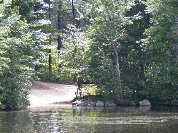
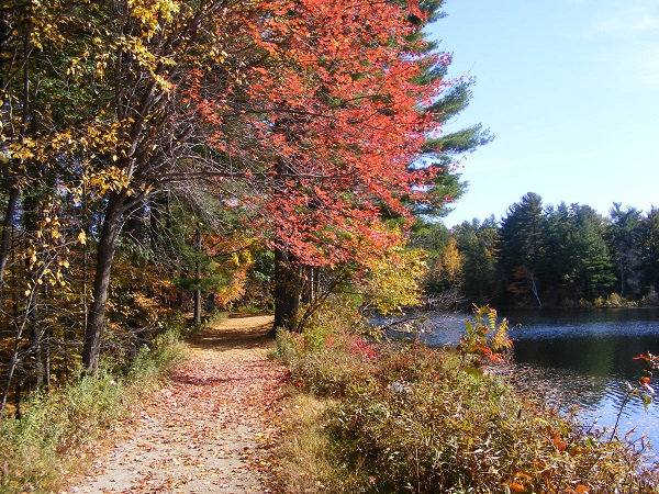
I broke away from work on this weekday just long enough to take my bicycle out for the first ride of the season on the Nashua River Rail Trail .

IMG__201704117__035415

Feature from mural along NRRT. Ellen Kolb photo.

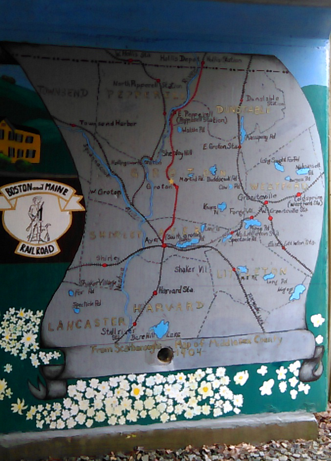
I like the mural in Groton, in the underpass crossing Route 111. I think local students must have painted it. It’s a map not of local streets, but of the Boston and Maine rail lines, including the decommissioned one that now serves as a trail. Nice bit of history, paying respect to the trail.


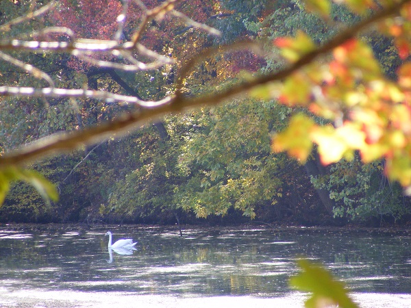
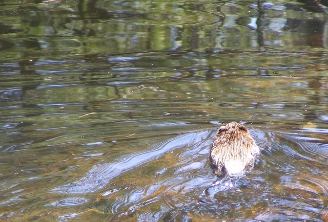
A beaver resisted all my attempts to photograph it. I almost missed it, in a swampy area alongside the trail: only concentric ripples gave it away. It’s good to see the wetlands looking like wetlands again, as gentle spring rains heal the effects of last year’s serious drought. Last September I had no more chance of seeing a beaver at trailside than of seeing a pod of whales.


The NRRT was dedicated fifteen years ago, and the road crossing at Route 113 in Pepperell has always required extra caution, from motorists as well as bicyclists. The ice cream shop across the street is one compensation. So is the pocket-sized park that’s been developed just south of 113. The shrubs are in bloom. Benches and markers have been spruced up. Something new – at least to me – is an air pump anchored in place, ready to tend to a summer’s worth of flat bicycle tires. That’s being neighborly.

IMG__201704117__034839

A little history to go with my stop along the trail.


The river that gave the trail its name is not visible from the trail, except for a lovely mile-long stretch in Pepperell and Groton. Every time I see it, I think of the guidebook I received when I moved to New Hampshire more than thirty years ago, which had this to say about the Nashua River in Pepperell, where there’s a dam:

…but for the dirty water this would be a fine smoothwater trip. From [Groton] to East Pepperell, the river is not attractive, as the increase in water level has flooded swampland and killed the trees. [AMC River Guide Volume 2, Appalachian Mountain Club, 1978]

By 2002, the Guide’s third edition told a different story.

The Nashua River has enjoyed a major restoration in the last 25 years. The industrial pollution is gone now. Birds, wildlife, and fish are returning, and paddling the Nashua River is now an enjoyable experience.

Walking and biking alongside the river is pretty enjoyable, too.

swan along NRRT

Nashua River, Pepperell, Massachusetts. Ellen Kolb photo.


Nashua Riverwalk: French-Canadian heritage

In my opinion, Nashua’s best river walk is the unpaved trail along the Nashua River in Mine Falls Park. I give credit to the city anyway for efforts to create an official “Riverwalk” linking Mine Falls and the area behind the old mills east of Main Street. One feature along the way is the city’s tribute to the early-20th-century French-Canadian mill workers.

Parc de Notre Renaissance Francais is tucked into a parking lot just off Main Street, between Water Street and the river. Along with the millworker statue are several plaques offering some information about the influence French-Canadian immigrants have had on Nashua’s industrial and cultural history.

If you’ve never seen this nearly-hidden bit of art and history, take a few minutes to visit it when you’re in town for the Nashua Holiday Stroll on the Saturday of Thanksgiving weekend.

All photos in this post by Ellen Kolb.

0515064136

0515064104

0515064151


Good days in Mine Falls Park

As the Granite State Walker blog turns 10 this month, I’m looking back at some of my favorite southern New Hampshire destinations. Today’s gallery:  Mine Falls Park in Nashua. This urban park is accessible from the Everett Turnpike (exit 5W, or 5E to Simon Street), Stellos Stadium, Lincoln Park, the Millyard downtown, or 7th Street off Ledge Street. If you live near Nashua and you haven’t explored this park yet, do yourself a favor and get out there!


kolb_boat-launchmf

Two boat launches serve the park, including this one outside Conway Arena.

kolb_mf-dam-late-afternoon

The dam at Mine Falls.

kolb_mfautumn

This path edges the millpond, home to heron and beaver.

kolb_mfhistory

A short history of the park.

kolb_mfmuskrat

Muskrats love the Mine Falls canal. The  canal, nearby Nashua River, and millyard cove are great areas for observing birds and wildlife.

kolb_snowymf

In the winter, I bring my snowshoes.

kolb_soifertmemorialmf

A memorial to a fallen Nashua-area Marine graces the walkway leading to the Mine Falls playing fields.

Roadside stops

I’ve found some fine little places to walk on the spur of the moment, pulling my car over into little parks and waysides. These walks aren’t long. I stop for them impulsively when I’m pressed for time, driving from point A to point B on some kind of business. Some wayside stops are too good to pass up. They help me clear my head for the next business meeting.

dscf0504

Runnell’s Bridge over Nashua River, Hollis NH.

There’s a little boat launch on the Nashua River just off NH 111 in Hollis. I parked here one day and took an unscheduled quick stroll on a nearby road, ending with a minute or two just enjoying the riverside. That hadn’t been on the day’s agenda, which was half the fun of stopping.

Here’s to quick stops and interrupted schedules. They can make my day.

Nashua River Rail Trail spring update

Conditions on the Nashua River Rail Trail are pretty good for the second week of April, especially in view of the exceptionally cold and snowy winter we had here in New England. I scouted a couple of parking areas and then walked the stretch between MA 113 in Pepperell and Sand Hill Road in Groton.

The trees aren’t yet in bud, so the river was the star of the show today.

Nashua River in Pepperell, Massachusetts, April 2015

Nashua River in Pepperell, Massachusetts, April 2015

Parking areas:

  • Gilson Road, Nashua: gate is open; ice and snow cover half the lot but about 20 parking spaces are clear and open.
  • NH Route 111-A at Nashua/Hollis line: plenty of roadside parking.
  • State line at Dracut: lots of snow was plowed into the far side of the lot, leaving room for three or four cars.
  • MA Route 113 in East Pepperell: clear and open.
  • Sand Hill Road, Groton: a snow pile covers about half the lot, but there’s still room for about ten cars.

Trail surfaces:

  • Pepperell: some patches of ice and snow, which should be gone soon with a few more 50-degree days.
  • Groton: mostly snow-covered between town line and Sand Hill Road. About three inches of well-trodden soft snow make for an uneven surface, but it’s certainly passable on foot.

It’s the beginning of another beautiful season on the NRRT. I’m looking forward to it.

Ice cream shop is open on Nashua River Rail Trail

image

I was surprised to find that the ice cream stand near the trail in Pepperell is open! The young man at the window told me it’s their first day of the season.

The trail between the NH/MA state line and MA113 is in good shape. Trail maintainers have cut & cleared all the trees damaged over the winter. It’s too early for wildflowers yet along the trail, but it’s a good time for birdwatching since the hardwoods haven’t leafed out yet. The Dunstable Coke machine is in action for the first time this spring. (If you ever walk the Nashua River Rail Trail between the state line and Pepperell, you’ll know what I’m talking about.) I picked a good day for my first 2013 trip to the trail.

The parking lot in Nashua at Gilson Road, the southern end of the rail trail, is open. It had been chained off as recently as a couple of weeks ago.

Watch out for a pair of Canada geese scouting out the ponds near the Dunstable-Pepperell line. I had to back off briefly when one stood in the middle of the trail & hissed at me. The pair moved away eventually.