With no formal vacation in sight, I can improvise. Just give me 24 hours and a car. Good hiking territory is essential, but so is a pleasant drive. Earlier this week, that meant heading up I-93 to Coos County.
Third Connecticut Lake area
Lone hiker, five miles from Canada
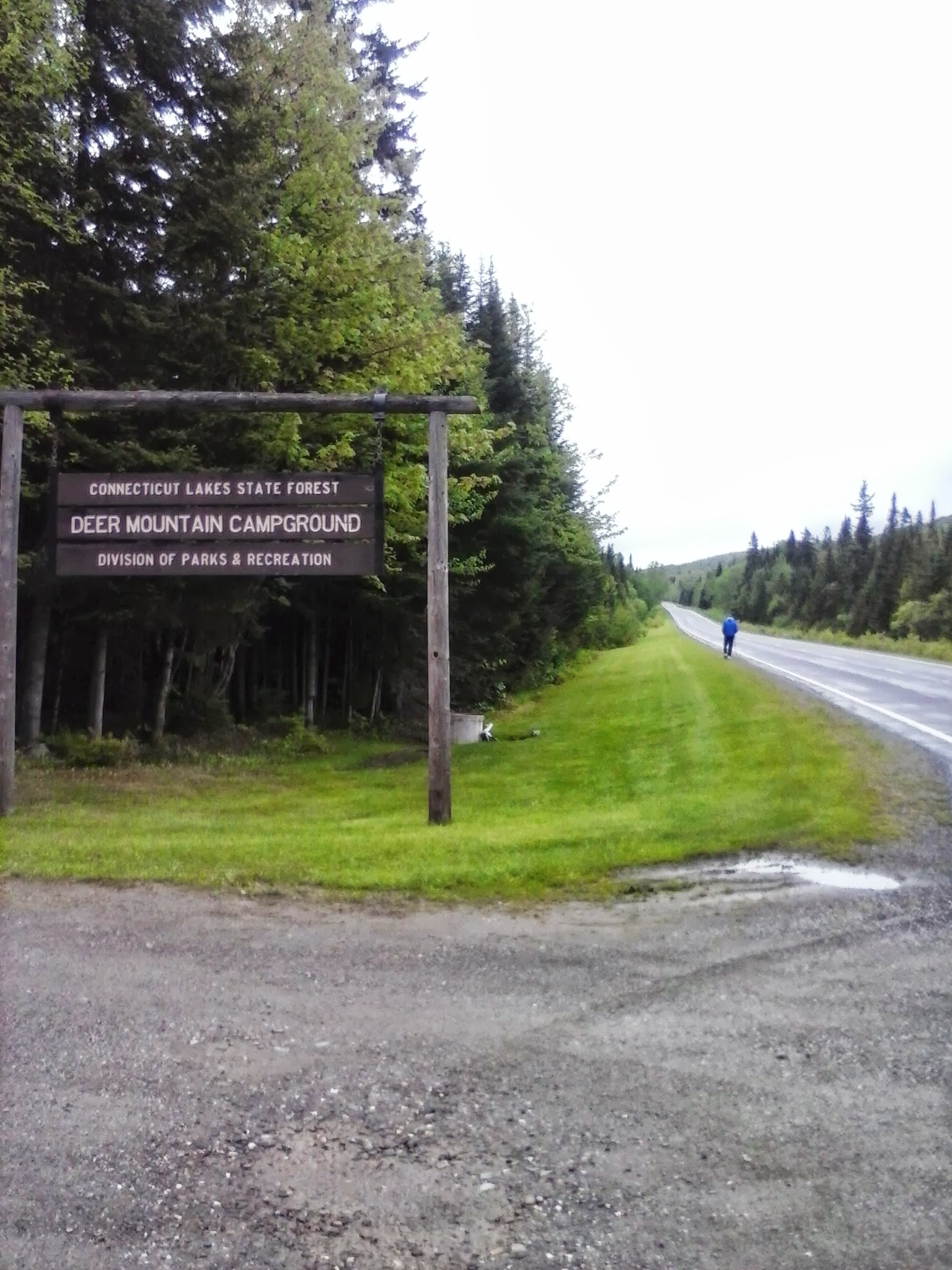
Site 28 at Deer Mountain State Park
This trip was inspired by a planned work project on the Cohos Trail, cutting a spur to the summit of Deer Mountain in the town of Pittsburg near the Canadian border. Unfavorable weather forced postponement of the trail work, leaving me free to wander familiar trails alone for a few hours. Very quiet overcast morning: no logging in the area this week, only two campsites occupied at Deer Mountain State Park, only one other hiker in sight. No hills on this trip, given my limited time in the area. US route 3 was nearly deserted. Snowmobile trail #5, on which the Cohos Trail piggybacks in this area, had a few mud puddles, but nothing dramatic. I enjoyed miles of walking the highway and the trail.
When I hiked through this area on a backpacking trip in ’09, the segment of trail now shared with the snowmobile trail was not yet on line. I was on pavement in 90 degree weather from Happy Corner to the Canadian border. I loved that trip, but I can tell you that cool drizzle is fine, too.
Stark
OK, I’m cheating here: I didn’t hike in Stark. I broke up the long drive to Pittsburg by stopping for a night at the Stark Village Inn, owned and operated by a member of the Cohos Trail Association board. The inn was homey and affordable. Nancy, the owner, is the soul of hospitality. She knows the trails in the area, and she’s been known to provide limited shuttle service.
View from Stark Village Inn
If I did decide to hike in Stark, I’d probably head up the Nash Stream Road from NH Route 110. Or maybe I’d head south of 110 toward the Kilkenny Ridge trail. Maybe I’d just walk along 110 and enjoy the sound and sight of the Upper Ammonoosuc River.
Colebrook and Columbia
I like Colebrook. It’s bustling, but it’s a tiny town nonetheless. Here, US 3 meets NH Route 26, which leads to Dixville Notch. Another day, I would have gone to the Notch for a short but lung-busting climb to Table Rock. No time on this trip, though. “Later,” I promised silently as I drove past NH 26, not weakening even when I drove past Le Rendez-Vous. That’s a bakery with amazing stuff, including irresistible chocolate croissants. (Update: Alas, since the publication of this post, Le Rendez-Vous has closed down.)
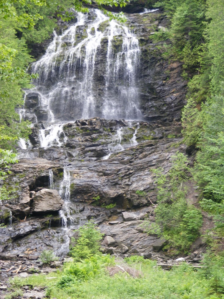
On NH 145 northeast of the center of town – a fun road, by the way – is Beaver Brook wayside area. It’s a feast for the eyes. There are short trails near the falls, especially nice in the summer when the spray from the falls is soothing on hot days. Pack a picnic.
Beaver Brook wayside area, Colebrook NH
I stopped in Columbia on my way home, just south of Colebrook, at the Shrine of Our Lady of Grace. It didn’t take long to walk the grounds. There are days when the shrine is thronged with pilgrims & tourists. I was there a few years ago during the annual Blessing of the Motorcycles, with hundreds of cheerful bilingual bikers. This week, I was alone. Different feeling altogether. For me, it was a place of prayer.
(Update: the Shrine closed in 2014. Part of the property has become the Tillotson Center, a community heritage, visual, and performing arts center.)
Shrine of Our Lady of Grace
The ride back to southern New Hampshire on US 3 went past some of my favorite hiking spots, including Weeks State Park. The pesky clock was ticking, though, and I kept driving. Once I was halfway home, the sun came out and the temperature went up 15 degrees. If I couldn’t have that weather for hiking, it was at least nice to have it for driving. No complaints, though. Those were twenty-four good hours.
Tenth in a series of posts journaling a 2009 hike on the northernmost section of the Cohos Trail.
(Update, 2026: The station at the international border between New Hampshire and Quebec has been enlarged substantially since my hike. One welcome addition is a small dedicated parking area for day trippers heading to Fourth Connecticut Lake without wanting to cross into Canada. Watch for signage as you approach the border. If you choose to hike across the border, do so only at the border stations on US 3. Be sure to have your passport or passport card with you. No exceptions.)
At Deer Mountain State Park in Pittsburg, New Hampshire, my sleep was untroubled until the first logging truck roared onto the dirt road just across the river from my campsite at 5 a.m. I’ve changed campsites for tonight.
I woke up to find everything in the tent damp from condensation. Very unpleasant, but not surprising. This muggy weather stays overnight, even though the heat takes a break for a few hours. Tonight, I’ll cram into a plastic garbage bag all items that will fit.
The heat really took a lot out of me today. I was such a sweaty mess when I got back from the border that I got cleaned up & changed as soon as I returned to camp, even though the day was far from over. T-shirt & shorts & the indispensable socks are hanging to dry after a good rinse in spring water.
I MADE IT!!! I’ve reached the northern end of the Cohos Trail. I crossed into Canada long enough to enjoy a snack on the hill overlooking Chartierville. I got here with NO northbound shuttles past Stewartstown, on my own two blistered feet, through rain & heat & pavement & rocks & weeds. I did it, I did it, I did it. I’m 50 years old, and I’ve just had a dream come true that would not have occurred to me at 40. And I have had so much fun in the process that it’s just plain ridiculous.
Amid all this lofty prose, the tent ceiling is drooping AGAIN. That’ll keep me humble.
Conditions for today’s hike were the same as yesterday’s, & the moose are still avoiding US 3 in the heat of the day.
As I passed Third Connecticut Lake, a coyote howled over & over from somewhere on the other side. I heard a loon somewhere out there as well. These were the only sounds – no traffic at those moments.
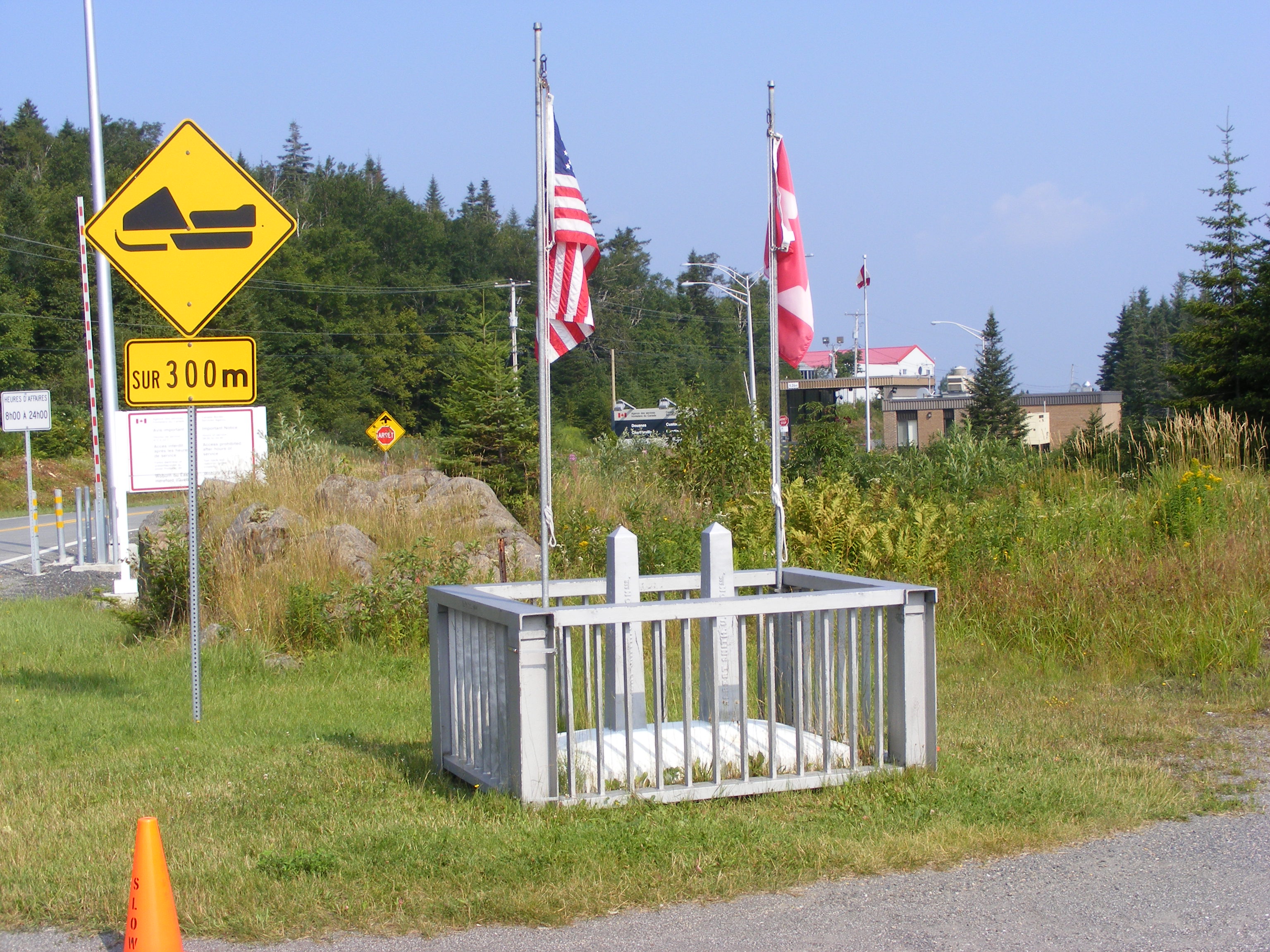
The border crossings were quick & uneventful. I stopped on the US side to confirm that I could get back in with my passport. I then walked to Canadian customs, stopping to photograph the boundary monument. I’m sorry no one was around to take a picture of me standing there. This was not a place to seek help from the border agents. Very serious men, every one. I can usually elicit a smile from people. Not these guys.
At the Canadian station, I discovered – oh, the letdown! The disappointment! – that they had no need to stamp my passport. The document therefore still looks unused. Stamp or not, though, I couldn’t have entered Canada or returned to the US without it. Glad I brought it. Upon seeing my lunch bag & my trekking pole, and probably getting a whiff of my unshowered body as well, the Canadian agent nodded at my request to cross over for a short walk. Looking at the posted list of prohibited items, I quickly added that I was carrying a jackknife. That almost drew a smile from the agent – a ghost of a smile was in there somewhere. He saw no need to inspect my little bag, and he sent me on my way.
I have been told that it’s amazing to cross into Quebec from NH because of the abrupt change from forest to farmland. Turns out that’s absolutely true. The view from the border is really quite striking: US 3 becomes Rt. 257, and it heads straight north to Chartierville, three miles away – downhill all the way in one gentle rolling drop after another. The day was too hazy for any good photo of this scene. Little town, lots of farmland, lots of signs in French: welcome to Quebec.
I decided after seeing that downhill road that I was not going to check out Chartierville. The trip back would have been time-consuming and, quite frankly, a drain on my legs, and I still had 4th Lake on the day’s agenda. Instead, I found a picnic area in a small meadow just past the border station, with three shaded picnic tables & a tourist kiosk & view to the north. I took out my water & my snack & enjoyed my 15 minutes of international travel right there.
The meadow was full of energetic cedar waxwings, flying from trees to meadow to picnic tables in search of worms or insects or whatever it is they live on. The heat wasn’t slowing them down a bit. They kept me quite entertained, though I was too slow to get good pictures. I never knew they could hover, but hover they did when examining a promising patch of ground.
Back to the USA. I told the agent I wanted to go on the Fourth Connecticut Lake trail, and he waved me toward it. Within about two minutes, I was very glad I hadn’t gone to Chartierville & back. This little trail went up a few hundred feet in seven-tenths of a mile. Wherever it wasn’t rocky, it was muddy. I needed the trekking pole, especially on the way down. But … I got there! Fourth Lake is a peaceful, unassuming little bog. It’s a marvel to think of the lakes I’ve seen on this trip all starting out here.
The walk back to camp in the afternoon was anticlimactic. I was hot & lethargic, & I went through my water much too fast. There’s a little unmarked pullout at 3rd Lake where small boats can put in. I stopped there to sit by the shore & cool off for awhile. I soaked my bandanna in the chilly water & then tied it around my neck. Heavenly. (That bandanna has been really good to have on this trip.) A couple from Florida sat nearby with their 3 dogs. The largest of the 3 was Mick, a boisterous creature who liked chasing his little Frisbee into the water. With the owners’ OK, I tossed the toy into the lake again & again, & Mick splashed right in to retrieve it & dog-paddle back to shore for another round. He would shake off cold water all over me after every retrieval. I loved it.
Back to US 3, grinding it out one step at a time. I promised my kids I’d do no hitchhiking, and never was that promise more sorely tested than today. I behaved myself, though, and returned to Deer Mountain under my own power. I stopped at the spring at the park entrance to refill my water bottle, and I drank a third of it down in one long pull.
No rest for the weary just yet. I was determined to change my campsite to avoid another 5 a.m. logging-truck wakeup call. I’m now just a stone’s throw away from the ranger’s office & house. I’ll bet logging trucks don’t wake HIM up at 5.
Relocated & freshened up by 3:30 in the afternoon, I dropped onto my sleeping pad & slept for an hour. A breeze blowing through the tent was a big help. When I woke up, I felt thoroughly refreshed, though really hungry. I put a good dent in the contents of the bear box, washing it all down with water. Delightful.
It’s 7:30 p.m. now, & I miss having a book, & I’m picturing my family watching Jeopardy!
Ooohh, I can feel the air mucking up again. Tent fly off, mesh wide open: let’s hope that keeps the humidity at bay.
NH’s northernmost state park, Deer Mountain, five miles from the Canadian border.
Ninth in a series of posts journaling a 2009 hike on the northern section of the Cohos Trail.
(Update, 2026: the Treats and Treasures store, later known as First Lake General Store, is no longer in business. Young’s Store is where to resupply in Pittsburg.)
I figured I’d be out for six hours today, & I was right. That included stops. I scurried out this morning without much breakfast, and I paid for that later, as five minutes’ thought would have warned me. No matter. I’m here, at Deer Mountain State Park, five miles from Canada.
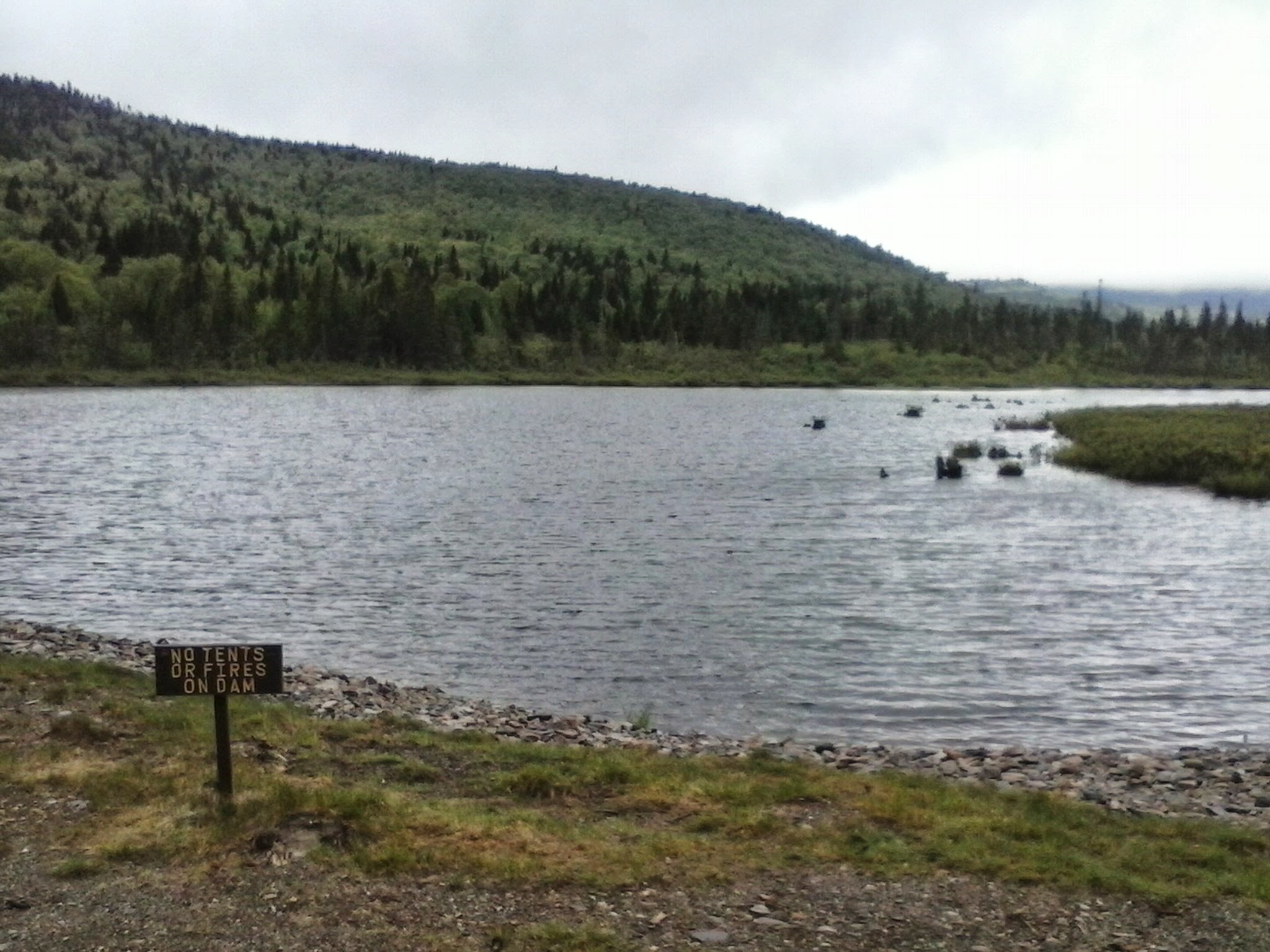
It took half an hour to walk from my Prospect Mountain quarters down to US 3. I stopped at a store a little north of Happy Corner to buy (& drink on the spot) a bottle of Gatorade. I knew I’d need the calories as well as the fluid. At Second Connecticut Lake dam, about two-thirds of the way to Deer Mountain, I stopped for 20 minutes because I was bonking. My no-breakfast decision caught up with me. I nibbled on a Powerbar & drank some water, then nibbled some more as a few minutes’ rest revived me. I lay on the grass in the shade, leaning against my backpack, feeling better by the minute. The spray from the dam was a treat.
Route 3 was hot and shadeless at midday. I saw no moose – not a one – though to be fair, any self-respecting moose spent today by a shady brook.
It’s the end of a summer weekend. I saw a fair number of out-of-state plates. Lots of day trippers came north with their kayaks, I presume for East Inlet. I saw so many motorcyclists that I worried they were all headed to Deer Mountain to camp, leaving me without a site. They weren’t, meaning they must have been Quebecois heading home.
I stopped at a spring on the roadside a bit north of Second Lake. While I was filling my bottles with that wonderful cold water, two people drove up to fill a pair of five-gallon jugs. They’re regulars here. They caught me up on the forecast for the next couple of days, and it sounds good, meaning no rain.
Humid, sticky day. I’ve been disappointed about not being able to hike up Magalloway, but that doesn’t bother me so much now. This may sound like sour grapes, but it’s been so muggy & hazy the past few days that visibility from the fire tower must be lousy.
It’s 5 p.m. now, there’s a soft breeze coming on, and the sun is becoming less harsh. Families are pulling into camp to claim their spaces. I saw the reservation sheet, and at least two sites have been rented for the week, starting today. It’s very peaceful here. I can see the attraction.
The attendant here, whose office is a little patio adjoining his cabin, recommended an out-of-the-way site for me. It’s right on Moose Flowage, as the Connecticut River is known in this stretch. I love the sound of the water, & while the site is buggy, I have DEET. Good enough. I actually have a couple of spots within the park that I can go to get away from the bugs. One is here, at the 2-table picnic area out front on US 3, beside the campground’s flagpole. The pole sports the most faded NH flag I have ever seen, and a somewhat less beaten-up American flag. Maybe a VIP coming to the Sentiers Frontaliers/Cohos Trail press conference Tuesday will be moved to spring for new ones.
ALMOST there. Third & Fourth Connecticut Lakes are just a few miles away. My goals tomorrow are to get to Fourth Lake and thus reach the current northern terminus of the CT, and to get over the border long enough to get my passport stamped. Lainie pointed out that bringing my backpack through Canadian customs, as I had planned to do, would be a headache. She’s right. I’ll try for the border tomorrow while my heavy equipment stays here.
The park attendant says the spring water here is fine, and I guess I believe him. He looks hydrated enough. He also said my bear canister was OK but probably not necessary. He hasn’t had a bear pester anyone here for three years. Fine. Let’s make it four. I’m using the canister. It’ll foil the raccoons, at any rate.
I’m sponging down my aching feet with my bandanna soaked in cool spring water. Ahhhh. The daily routine has been to soak my feet in cold water after a long day, dry them off, and put fresh padding around the nearly-healed blisters. (Another lesson from this trip: do not ever hike in wet socks.) That’s working well. My left knee was the day’s chief troublemaker. After 13 miles, it’s entitled to protest – just not for long.
A pair of hummingbirds entertained me for awhile when I arrived. I can hear plenty of other birds with unfamiliar songs. Sunburn & all, it’s been a glorious Sunday. This really is a lovely little piece of God’s creation.
Snug and dry as this tent was at Lake Francis, I’m still annoyed that I am never able to pitch it tight enough to keep the already-low roof from drooping. Also, I’m on a platform, and I’m still figuring out the best way to pitch and guy out my nonfreestanding tent. This trip is a learning experience. I’ve rolled back the fly and hooked it to the low side of the tent to keep ventilation going on this muggy evening. If it starts raining, I can have the fly up in a minute.
I can hear voices from nearby sites only faintly. I’m far from other sites but actually close to US 3.
I’ve put the bear canister a short distance from the tent platform. No bear is going to come after me, but I am concerned about a bear wanting my food if the food is tucked in with me. Perhaps I need a tad more fortitude.
OK, so I have fortitude of a sort. I’ve walked a fair chunk of the Cohos Trail alone. No one can ever take this away from me. I’ve also had some wonderful encounters with other people, & no one can ever take that away from me, either. This relatively inexperienced hiker is on top of the world.
For all the concerns expressed by family & friends as I prepared to take this trip, the most dangerous part of my walk so far was probably today, walking along US 3. Drivers were very friendly as they zipped past me in their fast little cars. But here I am, thank God, with no injuries but the ones I’ve inflicted on myself. My feet really do look like a podiatrist’s nightmare.
My husband wondered how I’d get by without reading material. He knows me well. I brought a magazine with me on the trip, and I decided to leave it at the Bungalow for the next occupants. I dropped every little thing I could spare to cut the pack’s weight, & I’m glad I did. But oh, I could go for something to read right now!
This trip is over the hump, & my husband & kids & home are coming in sight. It’ll be good to see them again. As soon as I get back home, it’ll be time to help my daughter pack for her departure to college. That seems awfully close now.
It’s nearly dark, and I’ve written enough. God grant me untroubled sleep & an uncomplicated day for tomorrow!
Sixth in a series of posts journaling my hike on the northern section of the Cohos Trail in 2009.
No travel scheduled today, also called a zero day by people who do more hiking than I do. I’m comfortably holed up in my little lodging on a hot summer day, listening to the Red Sox game on the radio. My remaining blisters are freshly padded & bandaged. I’ve had time today to look at the field guide on the table in here, trying to identify some of the birds I’ve seen this week. I had a wonderful nap this afternoon, though it cost me a few innings of the game. I’m sorting and re-packing all my things. A lazy day, though not a wasted one.
The remainder of my trip is firming up. Tomorrow, we have our kayak trip. Saturday is Old Home Day down in the village. I’ll catch a ride down there. Weather should be pushing 90 degrees, with no rain forecast for the weekend. The next day, I’ll hike to Deer Mountain SP, where I’ll stay for two nights. I’ll hike to the Canadian border & Fourth Connecticut Lake one of those days. Next Tuesday, there will be a press conference just over the border to celebrate the linking of the CT with the trail network of Sentiers Frontaliers (SF), a hiking group from Quebec’s Eastern Townships. I’ve arranged a ride to Pittsburg village afterward, where I have a place reserved for Tuesday night. Wednesday, if the weather’s good, I’ll get back to Sportsman’s Lodge (now closed) in one long haul, walking on Rt. 145 & Creampoke Road instead of the CT. Less favorable conditions will result in a break at Rudy’s. Either way, I’ll be finished ahead of my original schedule.
While I’m in the village, I’ll mail home my tent & sleeping pad & whatever else I don’t need to carry once I’m done camping. A light pack will help me get to Sportsman’s in one day, as will sticking to town roads (longer route but smoother path). Light load + good weather = excessive optimism.
This is all sounding manageable. Setting my own pace (slow) and schedule (flexible) has worked.
Summertime’s blue asters abound along the Cohos Trail.
Fifth in a series of posts journaling my 2009 hike on the northernmost section of the Cohos Trail.
(Update, 2026: the completed Round Pond trail was laid out on a route different from the one we flagged, which gave me a lesson in trail development: landowners can change their minds. See cohostrail.org for current information on the trail. Deer Mountain State Park is still there, an unpolished gem that should stay unpolished. Moose Alley Cones has a new location, closer to Back Lake.)
The trouble with full days is that I get tired in the evenings when it’s time to record the day’s events. Not a bad problem to have. Today was tiring, but quite satisfactory. My aching body is aching less, which is encouraging.
Today, I worked on a new segment of the Cohos Trail, which we all hope can soon be formally dedicated. I was with Lainie Castine, practically a legend among Cohos Trail builders. We started at Round Pond, where the proposed Round Pond Brook trail begins winding its way to US Rt. 3. As of now, the CT is on US 3 from River Rd. in Pittsburg to the Quebec border. Alternate routes & spurs are slowly being designed & approved, and will be developed piecemeal. The RPB trail was flagged by CT volunteers last spring, and state approval is pending, with a walk-through by a state official needed eventually.
Lainie handed me a pair of loppers & told me to follow her & look for flagging tape. Within 10 minutes, she realized that someone had come through & reflagged the trail on a slightly deviated route. Her GPS was only slightly helpful, but our compasses sure came in handy. I did very little lopping, but I helped get the trail’s flags back where they belonged.
A problem that became obvious — far more obvious on the Camp Otter Trail, where we worked in the afternoon – is that the flagging earlier in the year was done in the spring, before summer grasses grew several feet high. Some trail routes along snowmobile trails looked just lovely 4 months ago. Now, it’s midsummer. Grasses & ferns & the aptly-named hobblebush have grown several feet high. The snowmobile clubs won’t be working on the trails again until fall. The routes we checked today would pose a maintenance nightmare. Not an insoluble problem, to be sure, but a challenge.
We were on game trails when we weren’t on snowmobile trails. I saw a bobcat track for the first time. We saw plenty of moose tracks, as well as a spot in the Camp Otter area that’s obviously used by moose as a place to bed down. Bears left the most traces, though: prints, scat, more scat.
Coming out of the woods on the Round Pond Brook trail, before we got to US 3, we came upon a field full of Joe-Pye Weed and bee balm. This area is bursting with summer blossoms.
Camp Otter was an arduous couple of miles of slogging through mud & stumbling over long, tangled vegetation. This is the area where the trail association wants to put in 500′ of badly-needed bog bridging. I’m told that the materials have been acquired but are being stored down in Stark.
Rain began as we started to whack our way through the vegetation along Camp Otter trail. We were already so muddy that we didn’t care. Lainie is fine company, and she is undeterred by such minor matters as mud! Her attitude was contagious. She fed waypoints into her GPS, reflecting the improved trail route we flagged today. I became the first non-CT-board member to hike these segments. With breaks, it took us about 5 hours to walk/bushwhack/slog 4.1 miles. We felt like very wet pioneers when we were done.
We really were filthy by the time we were shuttled back to the Bungalow. Lainie insisted that I get first crack at the shower, and she was kind enough to put my muddy clothes along with hers right into her washing machine. Once I was cleaned up, I made a double batch of mac & cheese for a late lunch, and that simple little dish was perfect.
As I ate, I thought about some of the things I had planned to do on this trip. After only a couple of days with blisters, I had to admit to myself that Mt. Magalloway is out. I lost it the moment I dunked my feet in the mud on the Lake Francis trail and then didn’t dry them promptly. A steep uphill walk would be torture at this point, leaving me unfit for the other walking I need to do. There are already unexpected delights on this trip, though, in areas to which I could never have dayhiked from here.
Later, with my laundry hanging to dry, my hosts proposed a ride — “bring your camera!” We piled into their beat-up but valiant truck, and off we went.
First stop, Young’s, where everyone had things to pick up. Second stop: Moose Alley Cones, where I reveled quite messily in a double scoop of chocolate moose-tracks ice cream. Good thing I’d bought paper towels at Young’s. This ice cream stand had been on my to-do list for the trip, and I hadn’t told anyone about it, so this was an auspicious start to the road trip.
We proceeded north on US 3, the “Moose Alley” of all the tourist literature. We stopped at Second Connecticut Lake, at the boat ramp off the highway. We were the only people there. Once out of the car, I looked around in awe, overcome by profound silence. We were away from the dam at the lake’s south end, so there was no sound of rushing water. At that moment, there was no bird’s song or call, though I’m told loons are frequently seen here. No aircraft overhead, no carloads of tourists, no boats or boat motors – a place & a moment of peace, with nothing in view but the lake & the spruce trees all around.
From there, we drove north a couple of miles to Deer Mountain State Park, a campground with 20-some-odd sites. This gave me a chance to scout my quarters for next Sunday & Monday nights. Pleasant spot, lots of trees, Connecticut River the size of a brook rushing down a stretch called Moose Flowage: all good. The attendant lives on-site; we’re way beyond commuter territory. There’s no rec building or any other community structure. About a third of the sites were occupied, which confirmed my hope that a reservation & its fee would be unnecessary. I love the signs I’ve seen at all three state parks on this trip: “If office is closed, occupy any available site” – and leave the fee at the iron ranger, of course. Lots of honor-system operations up this way. As I expected, there’s no electricity at the park. In fact, we’d left the last US utility lines behind us a few miles back. The park also has no water supply aside from a single spring, piped up at a spot near the entrance.
Notes made & photos taken, I hopped back in the truck. We headed back south past Second Lake & turned east onto Magalloway Road. I noticed mile markers, and it turned out that all the back roads we were on last night had them. I suppose they’re useful, as long as you don’t expect to use a cell phone to summon help to your broken-down car at mile marker 3 on Magalloway Road. There is no cell signal there. (Update, 2026: cell service has come to portions of Pittsburg.)
These back roads, originally created by logging companies & still maintained in part by them, cut right through thick, thick woods. Spruce predominates. “Great North Woods” is no mere chamber of commerce conceit. We passed a number of small logging cuts that hardly put a dent in anything. The spruce all looked nearly black as the sun began to set.
At a fork we headed right, to Buckhorn Road. There were camps here & there, most of them looking neat & maintained despite the absence of cars in the driveways. The sky to our right was beginning to take on beautiful tints & tones in the last of the day’s light.
Another turn put us on Cedar Stream Road – the same Cedar Stream Road I’d found so boring a few days ago. We were miles farther east, though, at mile marker 19. This stretch was wilder, with fewer camps, and still no moose. We drove westward, & the full glory of the sunset was right in front of us. I could afford to enjoy it; I wasn’t the one who had to drive into the glare.
At the intersection where I had veered off to the Bog Branch bridge & the Lake Francis trail a few days ago, we turned left onto the east end of the nine-mile-long Deadwater Loop Road. This was the Wild America stretch, seen by very few flatlanders like me. This would have made a more interesting hike than Cedar Stream Road, coming from Rudy’s. I’ll remember that the next time I’m up this way.
Approaching the village, we turned onto Cedar Stream Road again, then Rt. 145 and then US 3. We drove onto giant Murphy Dam – giant for these parts, anyway. Pete told me this is an earthen dam, built in the 1930s.
Back on US 3, we passed the Pittsburg high school. I’m going to get a picture of the building on Old Home Day next weekend so I can show my son the home of the class S baseball champs. Their tournament victory made the front page of my downstate newspaper a few weeks back — a high school of 37 kids, with 14 of them on the team.
(As I write this, a small plane is passing overhead. That’s unusual here.)
The evening ride’s last leg was around Back Lake, ringed with inns and resorts. As we returned to Danforth Road after three unforgettable but mooseless hours, I said it would be funny if we drove over 40 miles & didn’t see a moose until 200 yards before the driveway. I was off by just a bit. On the way up Danforth, there was our one & only moose, waiting for us as if hired. Our tour was complete.