The Piscataquog Trail, Manchester NH

Judging from this year’s traffic on Granite State Walker, there’s been a surge of interest in the Piscataquog trail in Manchester. That’s fitting for a trail that’s conveniently located in New Hampshire’s largest city. The two-mile-long path crosses the city’s West Side, with interesting features along the way.

What do you need to know to appreciate this urban trail?

It’s a rail trail

The Piscataquog trail was built on an old rail line, one of many in New Hampshire converted to recreational use thanks to the vision and commitment of community members. As you travel along the path, watch for markers honoring some of the people who were instrumental in the trail’s development.

It features a pair of notable bridges

The trail is only a couple of miles long, but it features a pair of bridges that would be standouts on any longer path. At the east end near Delta Dental stadium where the New Hampshire Fisher Cats play baseball, the Hands Across the Merrimack bridge spans the Merrimack River, offering a fine view of Manchester’s mills and downtown towers. A bridge at the western end, near the West Side ice arena, crosses the Piscataquog River.
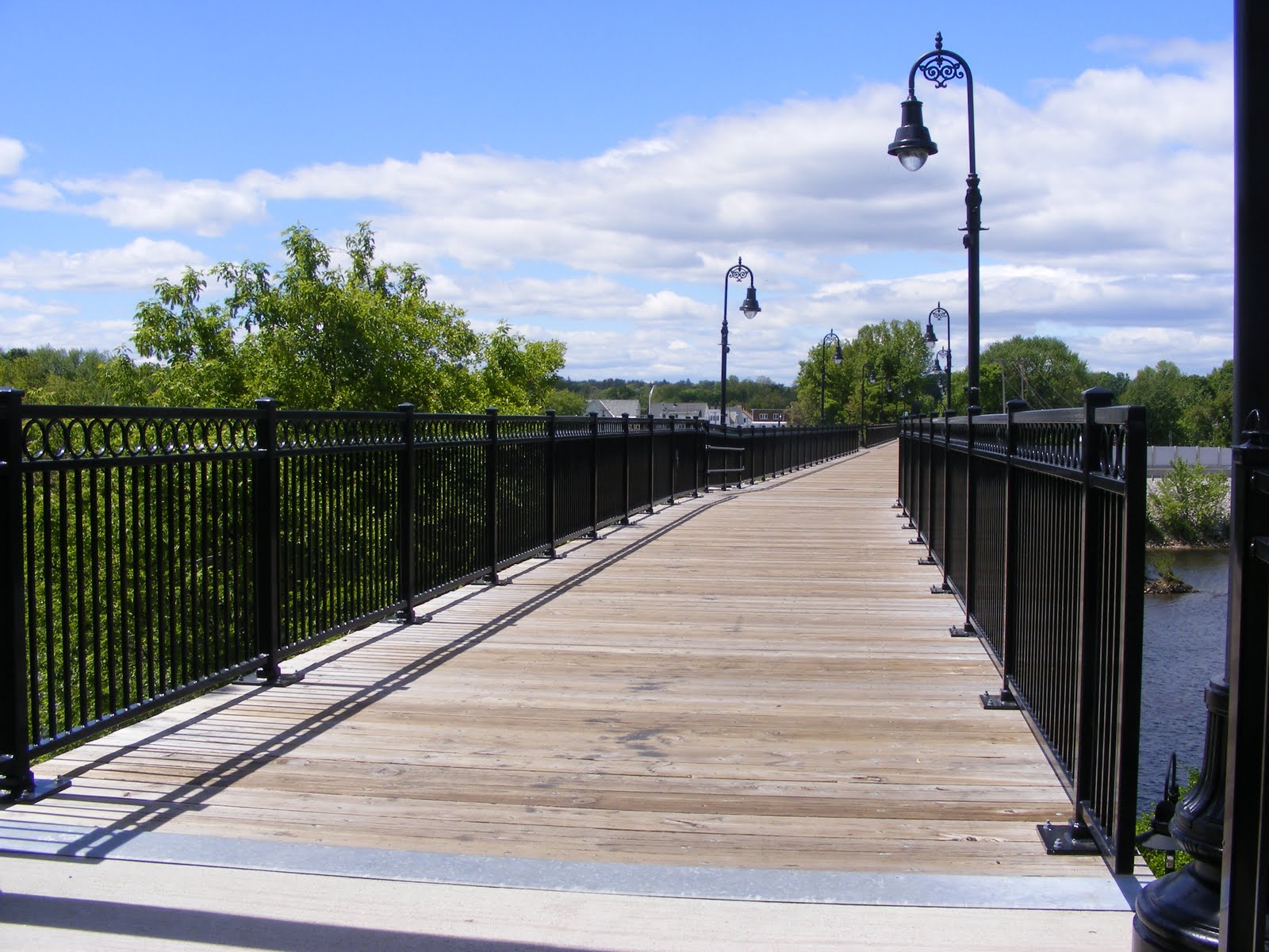
"Hands Across the Merrimack pedestrian bridge over Merrimack River in Manchester New Hampshire
The Hands Across the Merrimack bridge, where the Piscataquog Trail crosses the Merrimack River in Manchester NH. Photos by Ellen Kolb.

Both bridges are closed to motorized vehicles apart from e-bikes, providing cyclists and pedestrians a safer alternative to busy nearby streets.

Stay right

This is an urban trail, and it’s a busy one. Good trail etiquette promotes safety for everyone. Stay to the right side of the trail. Cyclists, yield to walkers and runners. That goes double for people on e-bikes, where speed and power can quickly lead to dangerous conflicts with other trail users.

If you’d like to learn more about peaceful coexistence on trails and roads, check out the Bike-Walk Alliance of New Hampshire.

Approach Main Street with caution

Manchester NH skyline with Merrimack River in foreground

Most of the Piscataquog trail’s road crossings are in quiet neighborhoods. Main Street on the West Side is in a class by itself, busy at all hours. Fortunately, there’s a pedestrian crossing beacon there that can be activated with the push of a button, triggering flashing lights to warn drivers of activity in the crosswalk.

Cross the city limit and you’re still on a trail

If you’d like to add miles or time to your outing, you’re in luck if you’re headed west. Just west of the Piscataquog River bridge, the trail changes from pavement to a neatly-maintained unpaved surface as it crosses the town line into Goffstown. Same old rail line, different town! The Goffstown Rail Trail extends west for five miles, all the way to the town center.
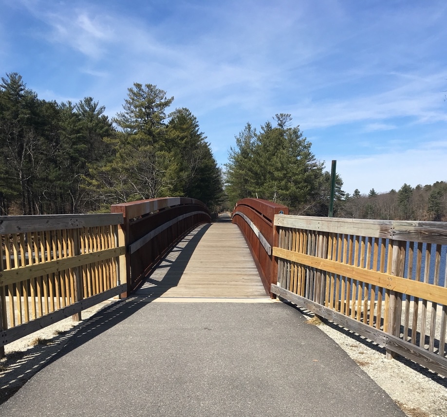
pedestrian bridge with wooden railings, on an urban trail
The Piscataquog trail bridge over the Piscataquog River…with the Goffstown Rail Trail just ahead.

Birdwatchers, bring your binoculars

The trail’s proximity to rivers and wooded neighborhoods mean it’s a fine route for spotting waterfowl and songbirds. If you’re lucky while you’re on the Hands Across the Merrimack bridge, you might even see a bald eagle! Eagles have nested not far downstream, and they like to feast on the river’s bounty.

Other connections: maybe someday

Perhaps in a few years the South Manchester trail will connect with the Piscataquog. For now, there’s a gap between the Delta Dental Stadium and South Willow Street near where the South Manchester trail begins. It’s hidden behind the shopping centers, and it continues south to Perimeter Road near the Manchester airport. That trail features a beautiful trestle bridge crossing Little Cohas Brook near the Perimeter Road end.

On the east side of the city, about two and a half miles from the stadium, the Rockingham Recreational Trail begins at Mammoth Road and continues east for more than 25 miles to the town of Newfields.

A note on trail safety

Whether you’re on an urban trail or miles away from the nearest town, the best practices for safety are the same: maintain situational awareness, and always let someone know where you’re going before you launch your adventure. Avoid anything that would prevent you from listening to (and watching for) what’s going on around you.

If you’re a Manchester resident and you enjoy using the Piscataquog trail, be sure to tell your representative on the Board of Aldermen. When local officials know that their neighbors support recreational trails, those trails are more likely to be maintained – with help from volunteers, of course.

The Granite State Walker blog will celebrate its 20th anniversary in 2026 – and more people have visited the blog in the past 12 months than ever before! With your support, GSW will keep highlighting some of the best non-motorized recreational opportunities in the Granite State, with an emphasis on southern New Hampshire.

Winter arrives on the Nashua River Rail Trail

The calendar says winter is a few days away, and late fall has been happy to provide a preview. I visited the Nashua River Rail Trail on a quiet weekday morning to take advantage of a just-above-freezing day. I wanted to beat the messy forecast: rain, followed by plummeting temps and a resulting flash-freeze.

I strapped cleats onto my shoes just to be on the safe side, since icy patches can lurk in a path’s shaded areas. The powder snow that fell earlier in the month was packed down nicely in an informal lane for walkers. There were traces of ski tracks alongside, but I think those must have been made when the snow was fresher.

I was on the northernmost segment of the trail, in Nashua. I was pleased to see that the city has kept the Gilson Road parking lot plowed. Many tracks in the snow between parking area and trail attest to the NRRT’s continuing popularity.

artwork displayed alongside a snowy trail in Nashua, NH
Along the Nashua River Rail Trail: “The Shapes of Water” by Faith T., a student at Nashua High School South. Ellen Kolb photo.

The art displays along the way between Gilson Road and the Rt. 111-A crossing featured pieces by students at Nashua High School South. Some of the display stands were showing signs of wear, and I hope the city will maintain them. The artwork is a meaningful way for Nashua to put its stamp on its section of the NRRT.

A bird’s nest was in the middle of the trail, perched atop the snow. A gust of wind probably took it down from a nearby tree. I picked it up thinking that it was edged with snow, but I was mistaken – all the white fuzz was from downy feathers. I moved the nest the edge of the trail, not wanting to damage it even if its former occupants were done with it.

Feathers, not snow, adorn this nest. Ellen Kolb photo.

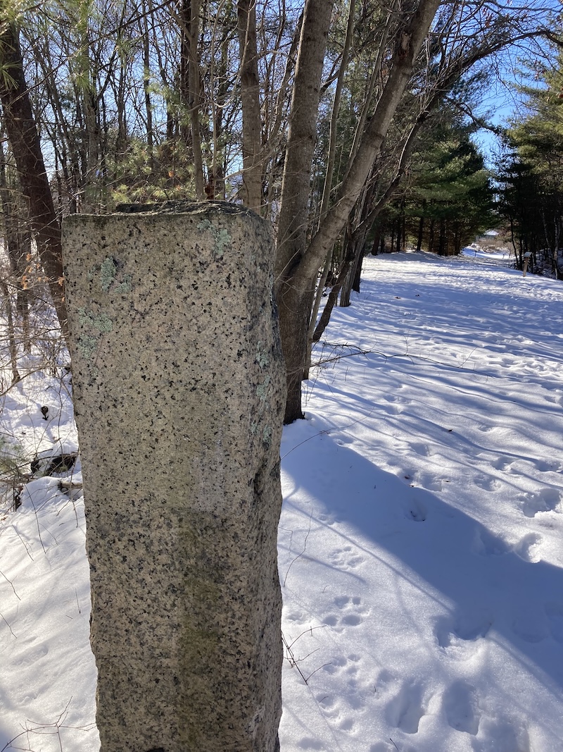
The painted markings on the old granite B&M railway mileage marker have weathered away. W 40, I thought to myself as I walked past it. Forty miles south to Worcester along the old rail line.

Granite post along a snow-covered rail trail
This granite post is a mileage marker, which once had “W 40” painted on it (40 miles to Worcester, Massachusetts). Ellen Kolb photo.

The twelve-mile long NRRT has several parking areas along the way. Trail users in Nashua can park by the trail on Gilson Road, NH Rt. 111-A, or Groton Road/Hollis Street (at the NH/MA state line).

You can help send the Granite State Walker to the next trailhead with a small donation at her Buy Me a Coffee page. Thank you!

“Open eyes and sturdy shoes”

“Today, you hike… I go because I want to and also because I can. I go because life doesn’t end once you’ve done enough. It keeps unfolding. And I intend to meet it with open eyes and sturdy shoes.”

That’s from the Blissful Hiker podcast by Alison Young. After my recent journeys recounted on this blog, her message resonates with me. I heartily recommend this nine-minute episode called “Aliveness”, for inspiration and encouragement.

Open eyes and sturdy shoes: I’ve been working on that here at Granite State Walker for nearly two decades now. It’s always good to meet fellow hikers similarly equipped. Walk on!

From blissful hiker ❤︎ inspiring you to hike your own hike: Aliveness, Jul 3, 2025
https://podcasts.apple.com/us/podcast/blissful-hiker-inspiring-you-to-hike-your-own-hike/id1515744759?i=1000715549476&r=269
This material may be protected by copyright.

Header photo by Ellen Kolb. Mount Kearsarge (south), NH.

One way to celebrate a birthday – part III: Androscoggin paths

The last north country day of my birthday celebration was spent with Marianne Barowski, who led the effort to create the Cross New Hampshire Adventure Trail (xNHAT). She is still its number one trail steward. I met her and a likeminded friend in Gorham, where we spotted a car before driving to Shelburne to start a walk down Hogan Road.

This is the third and final installment of the journal for this trip. Part I recounted my bike-defying walk in Franconia Notch, and in part II I sang the praises of the Presidential Rail Trail and the xNHAT.

Hogan Road

Hogan Road is one of the xNHAT segments that puts the “adventure” into “adventure trail.” It’s a woods road, easy for walkers, though its rough varied surface looks like it eats bike tires for breakfast. Busted culverts? Check. Smooth rocks, sharp rocks, indifferently-dumped gravel of random diameter? Check.

Then again, there were a few other things to notice. The Androscoggin River on the south side of the road is of surpassing beauty with Mount Madison rising in the distance. I snacked on wild black raspberries that put my granola bars to shame. I had good company, too. As a rule I prefer to travel solo. When I get the chance to walk a trail with its founder, though, “yes” is the only reasonable response.

Wide river, forested shoreline, mountain in the background, blue sky
From Hogan Road in Shelburne NH, Mount Madison is a striking backdrop to the Androscoggin River.

Stewardship, fellowship, gratitude

Our goal for the morning was to check the road’s condition with xNHAT users in mind, and add or replace directional signs as needed. Marianne carried a pack with the necessary equipment, while her friend and I were handy for consultation. That’s pretty much all she needed us for.

Companions on Hogan Road

This wasn’t a day for piling up miles. Rather, it was a day for fellowship and gratitude. Throughout my trip, I was the beneficiary of the work of trail stewards like Marianne. Her friend, who I think was new to the trail, became a steward that very day when we came to a turn where signage is hard to post and maintain. She went to work building a small cairn there – something that never occurred to me. It was a simple thing, and possibly temporary, but it was a fresh approach to a nagging little issue.

Along the way the river kept inviting us to stop and enjoy the view. It flowed past us silently at first. A few miles later, upstream, it was lively and loud, probably due to a release from the power dam in Gorham.

We discovered a Forest Society sign along the way, identifying the Shelburne Valley Forest, a recently-protected parcel of land that includes a portion of xNHAT. I think that augurs well for the future of passive recreation in the area.

Wrapping up

Returning home after my north country travels, I still had a few miles left to meet my goal. I put them on hold, briefly. My husband, not a hiker but very much an athlete, had a bike race scheduled in Maine two days later. Not a problem. I could walk in Maine.

It turned out that the town where we stayed in Maine had a fine bike/pedestrian trail for me. It ran along the Androscoggin River. Yes, the same river that sweetened the scenery along Hogan Road! I reached my goal there. I couldn’t have known when I started that the Androscoggin would stick with me until I was done. A friend of mine calls such coincidences “Godwinks,” and I’m not about to dispute her.

wide river, forested island, pastel-colored sky at sunset
Androscoggin River near sunset, Brunswick ME

Every step of the way, even when I felt absolutely beat, I was grateful for all of it. God is good. In a state full of hikers who knock off 4000-footers before lunch, I maxed out at 16 miles one day on flat trails. (You should have seen the pile of mac & cheese I had for dinner that night.) There’s room in this world for peak baggers and flatlanders alike.

That’s worth celebrating.


I’ll make an endorsement here, unsolicited and uncompensated: thumbs up to the Art Gallery Hostel in Whitefield, which served as base camp for my north country dayhikes. It’s economical, clean, and hiker-friendly. No meals are included, but there’s a kitchen. Dunks is next door, and a grocery store is down the street. Info at booking.com.

If you’d like to support Granite State Walker, you can buy me a coffee. Thanks!

One way to celebrate a birthday – part II: Presidential Rail Trail & Cross New Hampshire Adventure Trail

When last we met, I described a stop in Franconia Notch as I headed north for a birthday hike. Ultimately, half of my trip’s miles were along the Presidential Rail Trail (PRT). No two hikes there are alike, even from one day to the next.

Was I hiking, or was I walking? I know there are trail lovers out there who would scorn my use of the word “hike” to describe travel on any path that’s flat. I humbly ask their (your?) indulgence. If I’m on a paved surface, or an unpaved well-maintained town road, I’m walking. Anyplace else, I’m hiking.

Just go with it. Let’s get back to the PRT.

A cloudy day in Pondicherry Wildlife Refuge

Two days and half of my miles were on the PRT, my favorite rail trail. The first day was cloudy, the second brilliantly sunny, and each was splendid.

I began with the PRT’s path through Pondicherry Wildlife Refuge. My first stop was the viewing platform at Cherry Pond, an easy mile and a half from the Airport Road trailhead in Whitefield. The pond was covered with waterlilies. The only sounds were crickets, bees, some shy songbirds, and one distant jet way overhead.

Cherry Mountain and the Pliny Range were out the open, but the Presidentials to the east refused to come out from behind clouds. I gave them a chance, as I spent several hours between the trailheads at Airport Road and NH 115-A, but they simply weren’t going to show off for anyone not climbing them.

Meadow with summer wildflowers on a cloudy day with a mountain in the background
Cherry Mountain and Joe-Pye weed along the Presidential Rail Trail. Ellen Kolb photo.

Wild blossoms lined my way. I was pleased to see that Joe-Pye weed, while fading a bit, was still plentiful. I like its bold height and pink blooms. I was to see much more of it in the coming days.

Coming back at dusk to chase some sunset photos, I was surprised by a snowshoe hare popping out of the dense brush along the trail. Accustomed as I am to the pesky Eastern cottontails that abound in my southern New Hampshire neighborhood, I wasn’t used to seeing a larger, darker rabbit. But there it was!

Forested mountain range at sunset
A late afternoon view from the PRT: Mount Waumbek and the Pliny Range. Ellen Kolb photo.

The Cross New Hampshire Adventure Trail

The next day, there wasn’t a cloud in the sky. I was doomed to get sunburned.

The xNHAT – I’ll use the abbreviation favored by the trail’s founder, about whom more in part III – includes much of the PRT, but also a quiet residential unpaved Jefferson road called Valley Way. That’s where I got my sunburn. It’s also where I had all the views of the Presidential Range that were missing the day before.

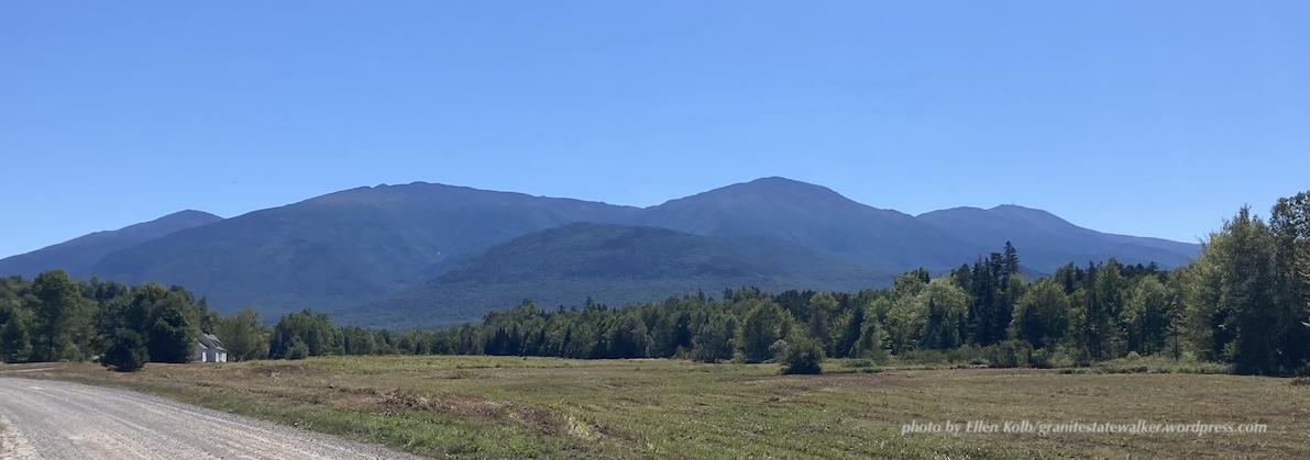
Panoramic view of the Presidential Range mountains in New Hampshire, seen from a nearby road
The Presidential Range seen from Valley Way in Jefferson NH. L-R: Mts. Madison, Adams, Jefferson, and Washington. Mt. Washington is the tallest, but seems shorter due to the angle from which I took the photo.

(I’ve written before about the xNHAT, which extends all the way across the state from Woodsville past Shelburne, ending in Bethel, Maine. My trip included only a couple of segments. Take a look at xnhat.org to learn about the whole trail.)

I started from Bowman, a trailhead off U.S. 2 in Randolph. From there I hiked west to NH Route 115, and then reversed direction as far as the Appalachia parking area. Having the car in the middle of my route gave me a place to eat lunch with my feet propped up. (My celebration, my rules.)

I started on the shady PRT, and when I got to Jefferson Notch Road I cut over to Valley Way. After all the clouds the day before, I was going to take the scenic route and enjoy the view of the Presidential range in all its summer glory.

Thumbs up to the friend of the trail who has established Paradise Meadow on Valley Way! This generous supporter has set up a little oasis on his own property for the benefit of xNHAT travelers. There’s room for a couple of tents, for the convenience of bikepackers or backpackers. More important for me as a day hiker were his other amenities, including a picnic table, a cooler full of bottled water, and a tidy discreetly-located pit toilet. I left him a thank-you note and a small donation in the little lockbox nearby.

Valley Way was superb, but I eventually switched back to the PRT for its soothing shade. While the PRT is parallel to and close by U.S. 2, the highway’s traffic is muted by the trees between trail and highway. A soft surface to walk on, shade above me, and wild black raspberries here and there made for a fine afternoon.

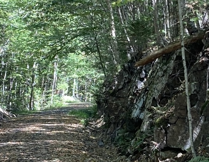
Shady woods trail
Shade along the PRT, and a rock cut dating back to rail days. Ellen Kolb photo.

In part III, I’ll take you to Hogan Road on the xNHAT, which might be Mr. Hyde to Valley Road’s Dr. Jekyll – though after several visits, Hogan and I have come to terms. It has beauty of its own. If you missed part I, you can find it here.

If you’re so inclined, you can Buy Me a Coffee – with my thanks!

One way to celebrate a birthday – part I, Franconia Notch Rec Path

Do you have something to celebrate, but you’re not sure how? Walking works for me.

My original plan for this year was to celebrate my birthday with a flourish. I’d backpack on my favorite New Hampshire rail trails, maybe over five days or so, for a number of miles equal to my age.

Ultimately, the plan was modified in every respect except the number of miles I wanted to walk. Dayhiking instead of backpacking; eight days, not five; August, not the actual month of my birthday. I included roads and park paths as well as rail trails. I skipped around New Hampshire, and even crossed into Maine for a bit.

Mission accomplished. I’ll help myself to cake at the earliest opportunity.

Let me share some highlights. Maybe you’ll get ideas for your own celebrations. I’ll split this into three posts, so if you like this one, you can look forward to two more shortly. If you don’t like this one, you can tune in later to see if I’ve upped my game.

Franconia Notch State Park

I’ve driven on I-93 through the notch more times than I can count. Knowing that Franconia Notch State Park has a paved recreational trail 9 miles long, I thought it was about time for me to enjoy the area at walking speed.

"The Basin", a small chute of water into a pool lined with smooth granite rock
The Basin in Franconia Notch State Park, NH. Dry summer, low water – and still a pleasant place to visit. Ellen Kolb photo.

The rec trail was a treat, once I came to terms with the cyclists sharing the path. There were more than a few e-bike renters who weren’t quite at home with their vehicles on the downhills. We gave each other space and cheerful greetings. I was there midweek, and I expect the experience might have been more hectic on a weekend.

I started at the Flume visitor center at the south end of the notch, and worked my way north. I stopped at the pretty Basin for a few minutes, and gave serious thought to joining a few people wading in the shallow Pemigewasset River just upstream. Warm day, cool water…but I kept going, knowing that up at Profile Plaza I’d find a place to enjoy my lunch with views of the surrounding mountains. The walk back to where I was parked was downhill, and I made sure to listen for speedy cyclists coming up behind me.

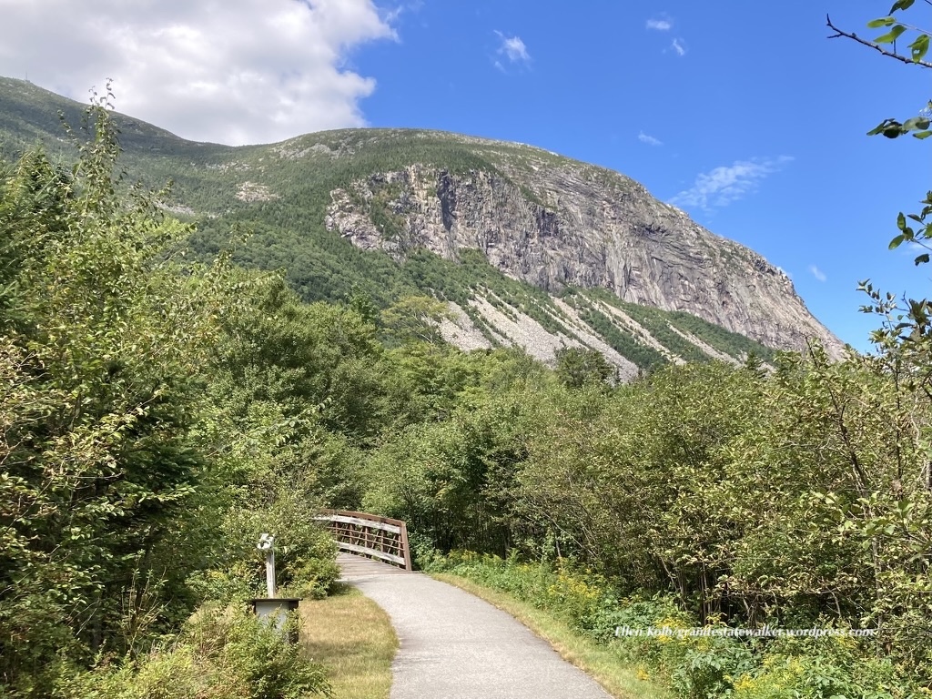
The Franconia Notch recreational trail and the cliffs of Cannon Mountain. Ellen Kolb photo.

Towards the southern end of the rec trail, I was on the Appalachian trail for about 30 feet. Maybe 20. We briefly shared a bridge, you see. AT hikers go through Franconia Notch the hard way. It wasn’t the last time I’d cross the AT on this trip.

I packed too much sweet stuff in my lunch bag. The rec trail goes through Lafayette Campground, where I found a nice little store stocked with Goldfish crackers. Pardon my crumbs.

If you head to the Notch and want to get oriented, the Flume visitor center at the south end of the park is the place to go. I used the nice clean bathroom there, knowing that facilities in the coming days were likely to be a bit more rustic.

Coming up in part II of the trip journal: two days and half of my miles were on the Presidential Rail Trail, which extends from Whitefield to Gorham. The first day was cloudy, the second brilliantly sunny, and each was splendid. Part III will cover the serene walk along Hogan Road, a unique section of the Cross New Hampshire Adventure Trail.

You can help Granite State Walker get to the next trailhead, simply by clicking on Buy Me a Coffee. Thank you!