I spent this uncommonly warm April day driving upstate to Bethlehem, Littleton, and finally Lancaster. This is a blog about southern New Hampshire trails, but today’s trip was pleasant enough to rate a mention.
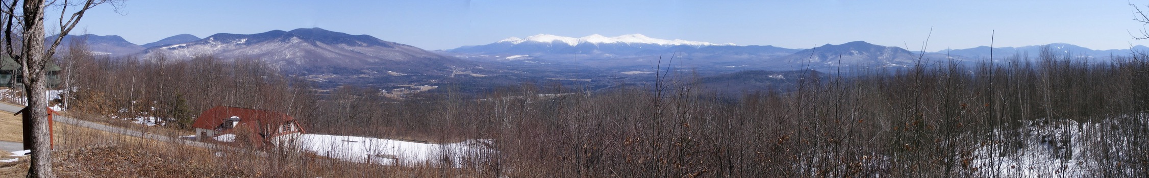
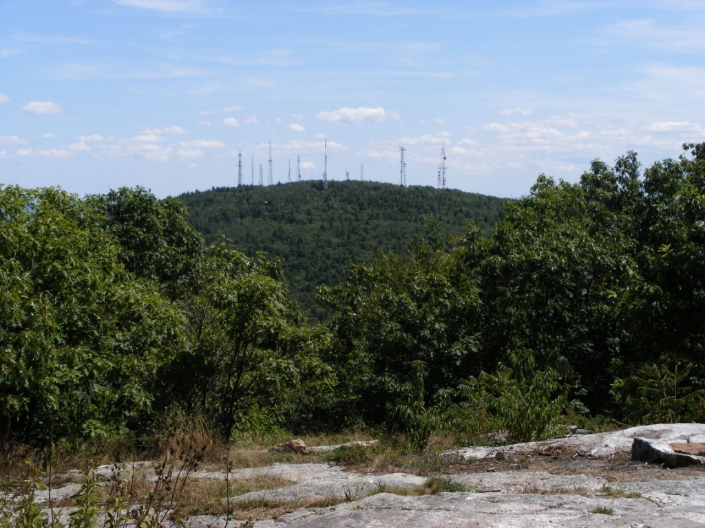
I found my way to the auto road up Mt. Prospect at Weeks State Park. The road is closed to auto traffic until sometime later this spring, but pedestrians may leave their cars at the base of the road and walk to the top. A pullout with a view of the Presidential Range makes walking even halfway up the road well worth the effort.
Looking east from the Weeks State Park auto road, Lancaster NH: the Presidential Range, snowcapped in April. Ellen Kolb photos.
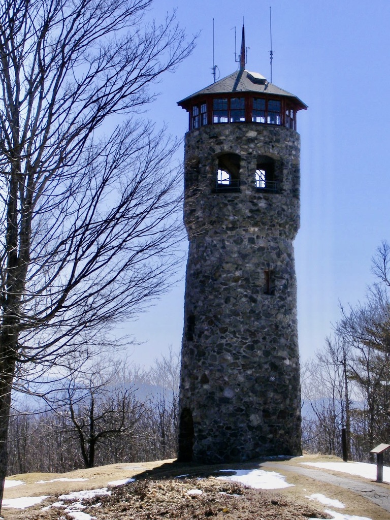
I didn’t walk all the way to Mt. Prospect’s summit on this trip, but I encourage readers to do so if they get a chance. The summit’s fire tower is unique. Instead of the usual metal skeleton, this one is a flagstone tower. This is an active firespotting station, and if you’re lucky, you’ll be there on a day when it’s staffed & the cab is open to the public. As you’d expect, the views are outstanding.
The entrance to Weeks State Park is on U.S. 3 in Lancaster, about 2 miles north of the Whitefield town line. Details are available at nhstateparks.org.
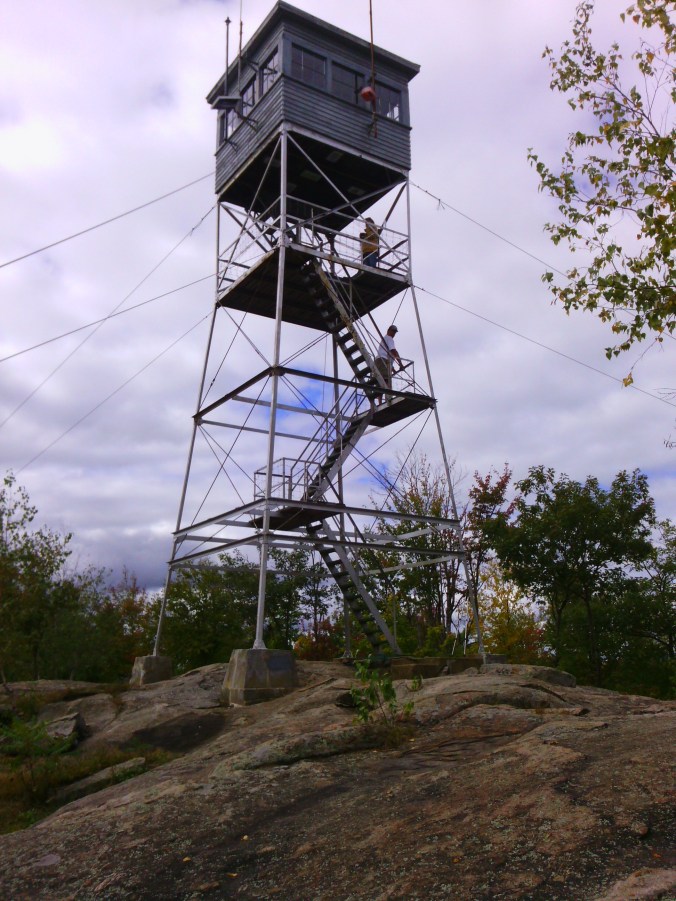
I spent a couple of hours at Pawtuckaway State Park in Raymond yesterday, still waiting on southern New Hampshire’s first snowfall of the season. Great time for a visit! I came in the “back” way, via Reservation Road in Deerfield, parking at the Round Pond Trailhead alongside a couple of other vehicles. I had no company on my walk to Tower Road and the fire tower. I’d never been to the tower without finding dozens of other hikers there, and I rather liked having the view to myself.
I enjoyed the sunny December day, but there was too much haze for me to catch sight of the Boston skyline.
(Update: Pawtuckaway State Park’s popularity skyrocketed during the Covid pandemic, prompting the state of New Hampshire to institute a reservation system for parking and beach use. The system has outlived the pandemic. Especially on weekends and holidays, check the park’s website for reservation information.)
Fire tower at Pawtuckaway State Park, 2010. It has since been rebuilt.
The Oak Hill trails in Concord, New Hampshire branch out from a parking area on Shaker Road, where ten cars (maybe a dozen, in a pinch) can fit comfortably. From NH Route 132 in the northeast part of town, turn onto Shaker Road and continue for about 2.4 miles. Watch for a sign on the right with a parking area.
The forested hill is laced with trails, with good vistas here and there. The fire tower at the summit, on the Concord-Loudon line, is a bonus, and you can get there by following Tower Trail, which is about two miles long and has signage along the way. Print out your map from the City of Concord’s website so you can find your way around the trail network.
My trail report from a visit on December 18, 2010:
Tower Trail is free of obstructions. The few bridges are intact. Oak Hill is still snowless, and the trail itself is ice-free except for a few small areas in the last few hundred yards leading to the tower. The frozen ground is covered with leaves that can be a bit slippery, and the surface is a bit uneven with rocks and roots. In other words, this is a typical woods walk.
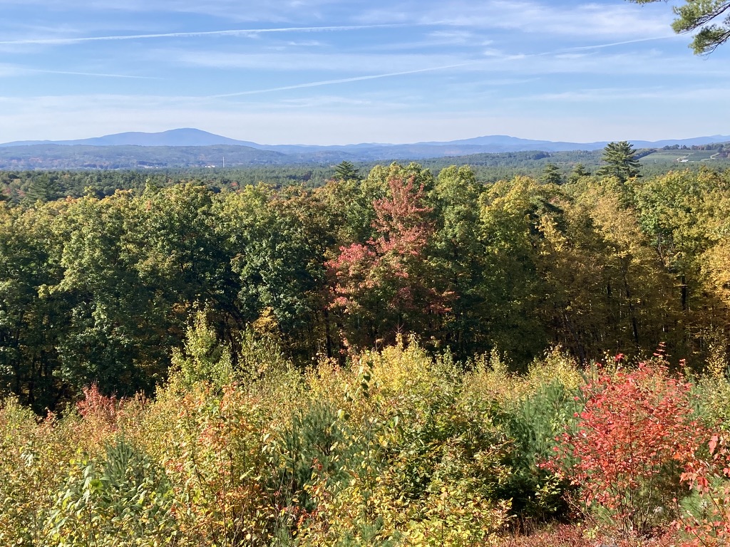
The last quarter-mile or so follows a power line straight to the fire tower, which is dwarfed by a pair of cell towers. The cab is unstaffed and locked this time of year. I was able to climb to the platform just below the cab, stopping at each landing to wonder just what the fire warden was supposed to survey. I had to get to the platform before the view and the breeze really opened up. Warner’s Mt. Kearsarge dominated the view to the west-northwest. There are hills in all directions, none of them snowcapped yet, though my view was limited by distant haze.
It’s about 500 feet of vertical rise from the trailhead to the tower, with a gentle grade. The hike took me 50 minutes each way, and a more fit walker could undoubtedly cut that time considerably. The full trail network on the hill covers about 7 miles, so a hiker could easily spend a day exploring the area. There are no toilet facilities at the trailhead.
The trailhead is less than 15 minutes’ drive from the State House, and the trail is in great shape. I’ll be back.
Looking west from the Oak Hill fire tower in Concord NH, the next active fire tower is on Mount Kearsarge (at left) in Warner.
Update, 2026: If the goffstowntrails.com website isn’t available, look for information on the Uncanoonucs and other Goffstown, New Hampshire trails at goffstownlibrary.com.
The twin Uncanoonuc hills in Goffstown, New Hampshire are my landmarks for knowing I’m nearly home whenever I come back from even a short trip out of my area. North Uncanoonuc looks forested and fresh, while South has 14 antennae and cell towers on its summit, making it look a bit like a geographic porcupine. I can’t complain too much about the towers, since I like having cell service & similar conveniences. Any map I consult calls these the Uncanoonuc Mountains, but when you read that, bear in mind that these “mountains” top out around 1300′.
North Uncanoonuc is always pleasant, with good views, no power lines, & no towers. Today, though, I wanted to check out the trails on the South mountain. Goffstown has produced a terrific map available on the town library’s website showing the trails that snake over & around both peaks. Mountain Road between the hills has several parking areas for hikers, and the entrance to the Reservoir road off Mountain Road now has a parking area with a map kiosk.
South Uncanoonuc Mountain with all its communications towers, seen from nearby North Uncanoonuc. Ellen Kolb photo.
I started up South Uncanoonuc from the kiosk for a short late-afternoon hike, carrying the map I had downloaded & printed. Conditions are typical for November. South’s trails are covered with slippery oak leaves, and a few of the boggy spots already have a thin skin of ice. Major trail intersections have either snowmobile signs or trail markers. Most minor trails as shown on the map are easy to spot, though they’re unsigned. A power line cut across the slope includes a well-defined trail, which today saw bike traffic along with a few hikers. It was a great day to enjoy the view of the city of Manchester from South’s summit ledges. I could almost forget that a cell tower was right behind me.
If I had had more time, I could have continued down the other side of South Uncanoonuc on either of two trails that end at Uncanoonuc Lake. A full morning or afternoon could easily be given to wandering these trails and visiting both summits. Bring water & snacks – the closest store & restrooms are on Mast Road, a couple of miles north of the trail kiosk on Mountain Road. There’s a paved road from South’s summit to Back Mountain Road, and if you want a good workout without going into the woods, you can drive to the summit (no good parking at the base)and walk down to the base & back. But why would I want to avoid the woods on a day like this?
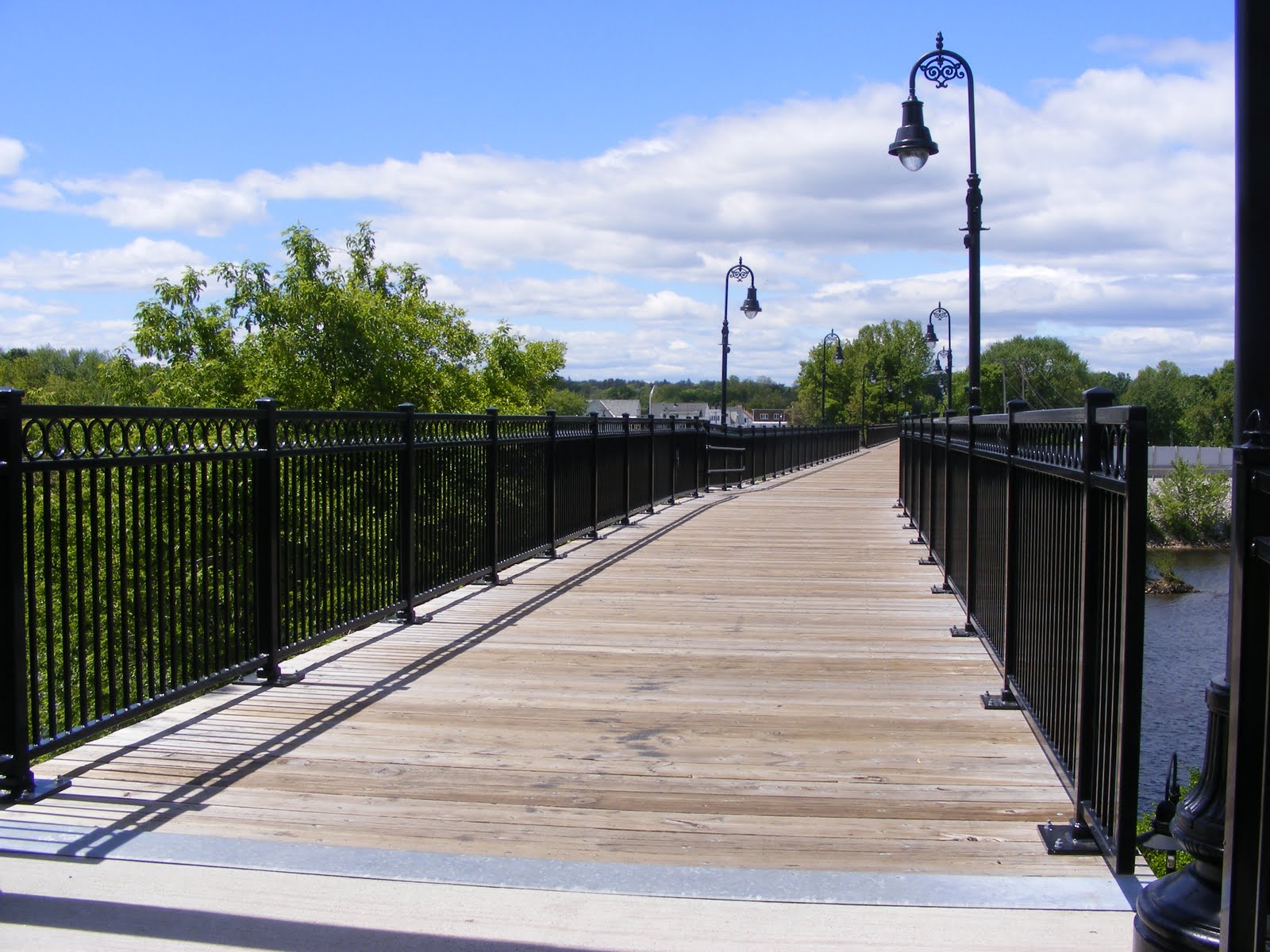
It took a whole lot of people, headed by Manchester resident Helen Closson, to make a pedestrian bridge out of the abandoned rail bridge across the Merrimack River in Manchester, New Hampshire. Closson called the project “Hands Across the Merrimack” while it was underway, and whatever name the pedestrian bridge may be given officially, that’s the name I’ll remember.
I’ve been on the bridge before, just for the fun of crossing over the Merrimack on foot. Today, after some business in town, I took advantage of the sunny afternoon to walk the rail trail clear across Manchester’s West Side. This is Manchester we’re talking about, so “clear across” means about two miles.
Starting from the baseball stadium where the Fisher Cats play on the river’s east side, a paved walkway runs parallel to the Merrimack and shortly comes to a fork. Going right would have brought me under the rail trail and onto some private property. Going left brought me around a sweeping curve to the approach of the Hands Across the Merrimack bridge.
I was a bit startled to find a sculpture of a steer just short of the bridge. The plaque mounted nearby noted that the statue was a tribute to workers & entrepreneurs like the ones from the former JacPac meat processing plant located nearby, now the site of a hospital expansion.
Vandalism has become an issue along the trail, judging from some news reports I’ve read. It looked good today, though. I’m sure that’s an ongoing effort by people who care. The trail is paved its entire length, and the pavement’s in good shape.
The bridge is at the southeast end of a trail that parallels the Piscataquog River. For now, the northwest end of the trail is near what I call the Kelley Street bridge (Nazaire Biron Bridge on my map) that links the West Side with the Pinardville neighborhood. There’s a very hazardous crosswalk on Main Street, but the few other road crossings are in quiet neighborhoods. The trail, like the rail line before it, goes on a bridge over Second Street, avoiding a road that’s just as busy as Main Street.
The Piscataquog River snuck up on me. I cleared Main Street & followed the trail behind a house where there was a cheerfully noisy party going on. As the music from the party faded behind me, I became conscious of the river’s sound, and soon the river was in view. A few weeks ago, we had heavy rains, and this river was particularly pesky for the people living along it. Today, though, it was a tame & pretty thing. Several dirt trails ran steeply from the trail down to the river. I stayed on the pavement, worried that I’d twist an ankle trying to negotiate the slope in my sneakers.
Eventually, I came to some ball fields, where a softball game was just wrapping up. Soon I was in sight of the ugly red bulk of West Side Arena. The building’s homely appearance belies its worth as an athletic facility for what seems like every kid on the West Side. Soon I passed under the Kelley Street Bridge and reached what is now the end of the trail.
Once upon a time, this rail line crossed the Piscataquog near Kelley Street, and then paralleled the river (on its north side now) through Goffstown & into New Boston. Patches of the line have been developed into trails. I’ve been on one segment in New Boston near where the middle & south branches of the Piscataquog converge — a beautiful spot. In Goffstown, determined residents have turned part of the old railbed into a trail, and they continue to try to finish the link between New Boston & Manchester.
[Update, 2015: that link, a bridge over the Piscataquog River, was completed in 2015. Trail users can go from Manchester’s baseball stadium all the way to Goffstown center.]
For now, though, all I saw after crossing under Kelley Street was a fenced-off trestle hung with “Keep Off” signs. I suspect that tight municipal budgets and concerns about liability will keep that trestle from ever being turned into a pedestrian bridge. Of course, that’s what I used to think about the bridge across the Merrimack. [Update: five years after I wrote this, the Piscataquog River trestle was indeed rebuilt, thanks in part to the generosity of the Singer family.]
This is not a path I would take after dark. I have no problem visiting on a weekend afternoon in broad daylight.
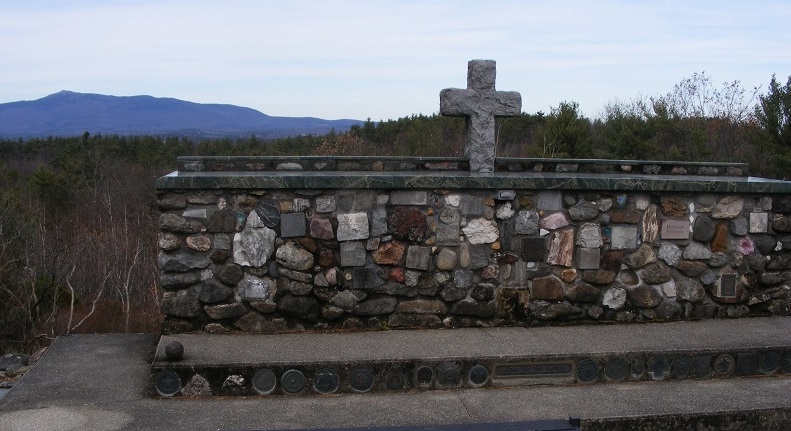
I wanted to remind my teenage son that Veteran’s Day is more than just a day off from school, especially since his older brother is in Iraq with the US Army. We headed out to Cathedral of the Pines in Rindge, which has special ceremonies every November 11.
The Cathedral’s web site calls the property a historical and natural site that is an open-air nondenominational sanctuary. Educational programs and public events promote peace and interfaith understanding while honoring the people who have served in our nation’s military. Symbols of the various branches of the military are displayed on the grounds, and there’s a special memorial to women in the armed services. The Altar of the Nation dedicated to our nation’s war dead is made from stones gathered from every state in the Union.
Mount Monadnock was in view, lending an air of permanence and serenity to everything around us. I found the Cathedral to be a fitting place to honor veterans from every era. This trip was a long drive for a short walk, and the effort was worth it.
The Cathedral of the Pines is located off Cathedral Road in Rindge, New Hampshire. Address: 10 Hale Hill Road.