The Oak Hill trails in Concord, New Hampshire branch out from a parking area on Shaker Road, where ten cars (maybe a dozen, in a pinch) can fit comfortably. From NH Route 132 in the northeast part of town, turn onto Shaker Road and continue for about 2.4 miles. Watch for a sign on the right with a parking area.
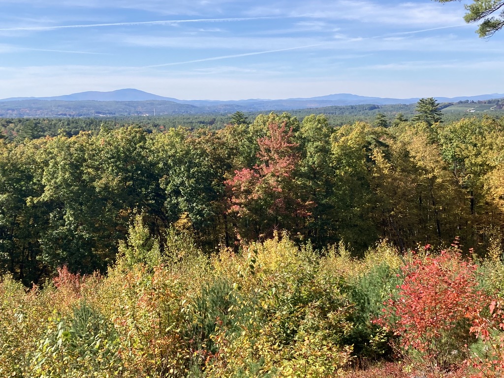
The forested hill is laced with trails, with good vistas here and there. The fire tower at the summit, on the Concord-Loudon line, is a bonus, and you can get there by following Tower Trail, which is about two miles long and has signage along the way. Print out your map from the City of Concord’s website so you can find your way around the trail network.
My trail report from a visit on December 18, 2010:
Tower Trail is free of obstructions. The few bridges are intact. Oak Hill is still snowless, and the trail itself is ice-free except for a few small areas in the last few hundred yards leading to the tower. The frozen ground is covered with leaves that can be a bit slippery, and the surface is a bit uneven with rocks and roots. In other words, this is a typical woods walk.
The last quarter-mile or so follows a power line straight to the fire tower, which is dwarfed by a pair of cell towers. The cab is unstaffed and locked this time of year. I was able to climb to the platform just below the cab, stopping at each landing to wonder just what the fire warden was supposed to survey. I had to get to the platform before the view and the breeze really opened up. Warner’s Mt. Kearsarge dominated the view to the west-northwest. There are hills in all directions, none of them snowcapped yet, though my view was limited by distant haze.
It’s about 500 feet of vertical rise from the trailhead to the tower, with a gentle grade. The hike took me 50 minutes each way, and a more fit walker could undoubtedly cut that time considerably. The full trail network on the hill covers about 7 miles, so a hiker could easily spend a day exploring the area. There are no toilet facilities at the trailhead.
The trailhead is less than 15 minutes’ drive from the State House, and the trail is in great shape. I’ll be back.
Looking west from the Oak Hill fire tower in Concord NH, the next active fire tower is on Mount Kearsarge (at left) in Warner.
Update, 2026: If the goffstowntrails.com website isn’t available, look for information on the Uncanoonucs and other Goffstown, New Hampshire trails at goffstownlibrary.com.
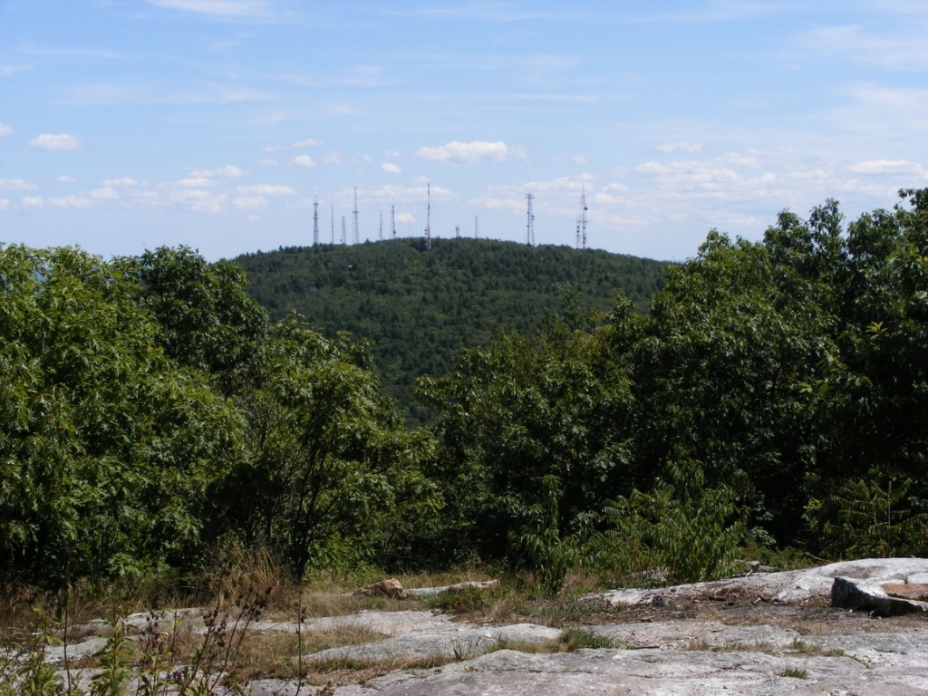
The twin Uncanoonuc hills in Goffstown, New Hampshire are my landmarks for knowing I’m nearly home whenever I come back from even a short trip out of my area. North Uncanoonuc looks forested and fresh, while South has 14 antennae and cell towers on its summit, making it look a bit like a geographic porcupine. I can’t complain too much about the towers, since I like having cell service & similar conveniences. Any map I consult calls these the Uncanoonuc Mountains, but when you read that, bear in mind that these “mountains” top out around 1300′.
North Uncanoonuc is always pleasant, with good views, no power lines, & no towers. Today, though, I wanted to check out the trails on the South mountain. Goffstown has produced a terrific map available on the town library’s website showing the trails that snake over & around both peaks. Mountain Road between the hills has several parking areas for hikers, and the entrance to the Reservoir road off Mountain Road now has a parking area with a map kiosk.
South Uncanoonuc Mountain with all its communications towers, seen from nearby North Uncanoonuc. Ellen Kolb photo.
I started up South Uncanoonuc from the kiosk for a short late-afternoon hike, carrying the map I had downloaded & printed. Conditions are typical for November. South’s trails are covered with slippery oak leaves, and a few of the boggy spots already have a thin skin of ice. Major trail intersections have either snowmobile signs or trail markers. Most minor trails as shown on the map are easy to spot, though they’re unsigned. A power line cut across the slope includes a well-defined trail, which today saw bike traffic along with a few hikers. It was a great day to enjoy the view of the city of Manchester from South’s summit ledges. I could almost forget that a cell tower was right behind me.
If I had had more time, I could have continued down the other side of South Uncanoonuc on either of two trails that end at Uncanoonuc Lake. A full morning or afternoon could easily be given to wandering these trails and visiting both summits. Bring water & snacks – the closest store & restrooms are on Mast Road, a couple of miles north of the trail kiosk on Mountain Road. There’s a paved road from South’s summit to Back Mountain Road, and if you want a good workout without going into the woods, you can drive to the summit (no good parking at the base)and walk down to the base & back. But why would I want to avoid the woods on a day like this?
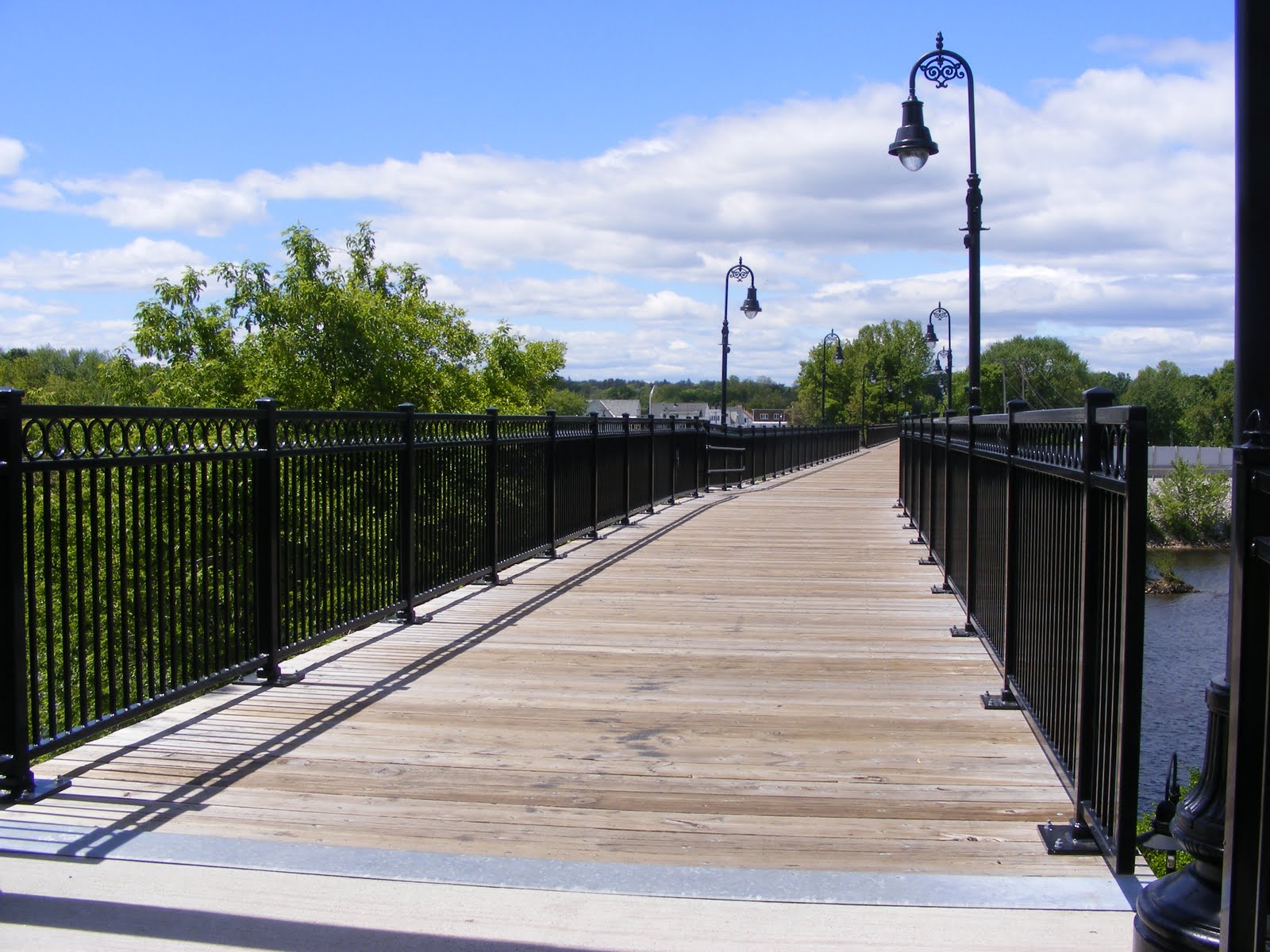
It took a whole lot of people, headed by Manchester resident Helen Closson, to make a pedestrian bridge out of the abandoned rail bridge across the Merrimack River in Manchester, New Hampshire. Closson called the project “Hands Across the Merrimack” while it was underway, and whatever name the pedestrian bridge may be given officially, that’s the name I’ll remember.
I’ve been on the bridge before, just for the fun of crossing over the Merrimack on foot. Today, after some business in town, I took advantage of the sunny afternoon to walk the rail trail clear across Manchester’s West Side. This is Manchester we’re talking about, so “clear across” means about two miles.
Starting from the baseball stadium where the Fisher Cats play on the river’s east side, a paved walkway runs parallel to the Merrimack and shortly comes to a fork. Going right would have brought me under the rail trail and onto some private property. Going left brought me around a sweeping curve to the approach of the Hands Across the Merrimack bridge.
I was a bit startled to find a sculpture of a steer just short of the bridge. The plaque mounted nearby noted that the statue was a tribute to workers & entrepreneurs like the ones from the former JacPac meat processing plant located nearby, now the site of a hospital expansion.
Vandalism has become an issue along the trail, judging from some news reports I’ve read. It looked good today, though. I’m sure that’s an ongoing effort by people who care. The trail is paved its entire length, and the pavement’s in good shape.
The bridge is at the southeast end of a trail that parallels the Piscataquog River. For now, the northwest end of the trail is near what I call the Kelley Street bridge (Nazaire Biron Bridge on my map) that links the West Side with the Pinardville neighborhood. There’s a very hazardous crosswalk on Main Street, but the few other road crossings are in quiet neighborhoods. The trail, like the rail line before it, goes on a bridge over Second Street, avoiding a road that’s just as busy as Main Street.
The Piscataquog River snuck up on me. I cleared Main Street & followed the trail behind a house where there was a cheerfully noisy party going on. As the music from the party faded behind me, I became conscious of the river’s sound, and soon the river was in view. A few weeks ago, we had heavy rains, and this river was particularly pesky for the people living along it. Today, though, it was a tame & pretty thing. Several dirt trails ran steeply from the trail down to the river. I stayed on the pavement, worried that I’d twist an ankle trying to negotiate the slope in my sneakers.
Eventually, I came to some ball fields, where a softball game was just wrapping up. Soon I was in sight of the ugly red bulk of West Side Arena. The building’s homely appearance belies its worth as an athletic facility for what seems like every kid on the West Side. Soon I passed under the Kelley Street Bridge and reached what is now the end of the trail.
Once upon a time, this rail line crossed the Piscataquog near Kelley Street, and then paralleled the river (on its north side now) through Goffstown & into New Boston. Patches of the line have been developed into trails. I’ve been on one segment in New Boston near where the middle & south branches of the Piscataquog converge — a beautiful spot. In Goffstown, determined residents have turned part of the old railbed into a trail, and they continue to try to finish the link between New Boston & Manchester.
[Update, 2015: that link, a bridge over the Piscataquog River, was completed in 2015. Trail users can go from Manchester’s baseball stadium all the way to Goffstown center.]
For now, though, all I saw after crossing under Kelley Street was a fenced-off trestle hung with “Keep Off” signs. I suspect that tight municipal budgets and concerns about liability will keep that trestle from ever being turned into a pedestrian bridge. Of course, that’s what I used to think about the bridge across the Merrimack. [Update: five years after I wrote this, the Piscataquog River trestle was indeed rebuilt, thanks in part to the generosity of the Singer family.]
This is not a path I would take after dark. I have no problem visiting on a weekend afternoon in broad daylight.
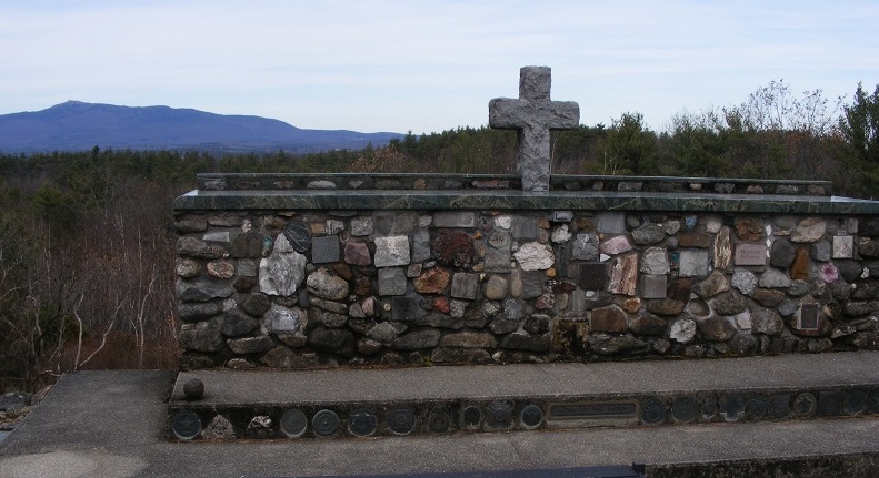
I wanted to remind my teenage son that Veteran’s Day is more than just a day off from school, especially since his older brother is in Iraq with the US Army. We headed out to Cathedral of the Pines in Rindge, which has special ceremonies every November 11.
The Cathedral’s web site calls the property a historical and natural site that is an open-air nondenominational sanctuary. Educational programs and public events promote peace and interfaith understanding while honoring the people who have served in our nation’s military. Symbols of the various branches of the military are displayed on the grounds, and there’s a special memorial to women in the armed services. The Altar of the Nation dedicated to our nation’s war dead is made from stones gathered from every state in the Union.
Mount Monadnock was in view, lending an air of permanence and serenity to everything around us. I found the Cathedral to be a fitting place to honor veterans from every era. This trip was a long drive for a short walk, and the effort was worth it.
The Cathedral of the Pines is located off Cathedral Road in Rindge, New Hampshire. Address: 10 Hale Hill Road.
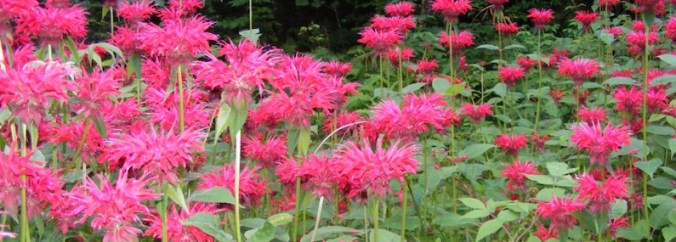
Summertime bee balm along the Cohos Trail. Photo by Ellen Kolb.
Twelfth and last in a series about my Cohos Trail section hike in 2009.If you’ve enjoyed reading about this journey, I hope you’ll consider supporting the Granite State Walker blog. Thank you!
After seven hot hours, I made it from Pittsburg village to Sportman’s Lodge (now closed). It was much more comfortable, not to mention faster, to be walking without a tent or pad or several days’ worth of food.
I slept like a baby last night. No matter how I try, there’s just no way I feel as secure in a tent as I do in a place like a cabin with a lock on the door.
I decided to spend some of my fast-dwindling cash supply on a really, really good breakfast. I went to a diner near my cabin, where the lone waitress was cheerfully attending to a nearly-full house. I ordered my plateful of food along with coffee & OJ, and then heard a cheerful greeting from the next table. I looked over and there was Armand, sitting with his buddies over coffee. A small town, indeed.
When I finished up, I bought a couple of bottles of some kind of flavored non-carbonated water-type stuff (couldn’t they just carry Gatorade??). Armand called out “May it all be downhill.” Surely, there’s no finer farewell for a hiker! We were laughing as I stepped outside for the last leg of the trip.
I took Rt. 145, & when I got to Clarksville Pond Rd., I took one look down Old County Road & decided to stay on 145 until Creampoke Road. When I got to the 45th Parallel marker, I hung my hat on its corner and propped my pack & trekking pole against the sign’s support pole & then took a picture. It occurred to me then that I should have been using that hat as a photographic prop throughout the trip.
145 climbs a bit leaving Pittsburg and heading through Clarksville. I cheered when I got to the little signs warning trucks to use low gear, knowing that meant a downhill stretch was coming up. On Creampoke Road’s long eastward run, a truck slowed down beside me & the driver said “Didn’t I see you in Pittsburg this morning?” Darned if it wasn’t one of Armand’s breakfast companions! We went our separate ways after a brief cheerful chat.
I packed 40 ounces of drinks & should have packed more. I packed 3 energy bars, & I could have done with one. Solid food seemed an unnecessary distraction.
After turning from Creampoke to Haines Hill Road which becomes Macallaster Road, I came to a fork that puzzled me. There was a logging cut on the left with a path through it, and a path like a snowmobile trail off to the right. I remembered going past a logged area when I came up here, but I hadn’t seen the fork from that direction. I used the 10-minute rule that has served me well on the trip, and I didn’t even need the full 10. About 3 minutes of walking into the log yard showed me a dead end on a little knoll.
Suddenly, I heard my phone buzzing. That little hill brought me into cell range, probably pinging off a Canadian tower. I was receiving a text my daughter had sent the night before. I texted her back with an update on my location.
Out of the logging yard, onto the other path, out of cell range: right back where I belonged. My compass confirmed I was heading SSW, close enough to south to be reassuring. The path gradually widened. I came around a curve and saw a massive tree down across the road. Suddenly, I remembered the tree from my northbound walk, and I knew where I was. The tree had been leaning over the road quite precariously when I last saw it. Once past the tree, I recognized the farm ahead, and soon I reached Bear Rock Road. The route was a piece of cake from there, with nothing ahead but signed town roads. By the time I got to Diamond Pond Road, I was dragging, but I knew I was almost done.
Coleman State Park at last! It was just a mile away from my goal, and I was more than ready for water when I got there. The park was deserted except for me and a lone motorcyclist. I dropped my pack & trekking pole on a picnic table & made a beeline for the nearest faucet. I filled my bottle & drank it straight down, savoring shade & water. A faint cell signal let me text my family that I was nearly done. My daughter sent a joyous message back a few moments later. In the patchy world of cell phone service in Coos County, there’s a faint signal at Coleman and no signal at all at the lodge a mile away.
Twenty minutes later, I was at the lodge. I let my host know I was back, told him I needed no dinner service, and went straight upstairs for a shower, clean clothes, and some rest. I felt utterly exhilarated.
We’ve had a good evening here, watching the Red Sox game. My hosts, husband and wife, treated me like an honored guest. Corey, a neighbor whom I met at last year’s Cohos Trail gathering, greeted me like an old friend & wanted to hear about the hike. We all chatted, criticized our pitcher (Buchholz tonight), & put up with dogs & cats vying for attention. I called it a night after 5 or 6 innings.
My inventory of bodily damage from this escapade actually amounts to a short list. Blisters: healing. Toes: A few discolored toenails. Nothing I haven’t seen before. Sunburn: during one stop along the way today, I was alarmed to see little blisters in patches on my shins. I’ve got sunburn over sunburn. I didn’t bother with sunscreen today because I figured I’d only sweat it off within the hour. I now have a painful reminder to USE it hourly, if necessary. I intend to lecture my kids about this. (They’ll ignore me. At their age, I didn’t want to hear it, either.) Left knee: An arthritic joint, to be sure, now sore to the point where I need a pillow under it when I lie down. Nothing new. Naproxen & rest will help.
Tomorrow: laundry, reading, review my photos, and maybe do some kayaking (with lots of sunscreen) on Big Diamond Pond. The day after that, my husband will be here to pick me up and get his first look at the area.
Let’s see: 17 to 19 miles for today, depending on the relative accuracy of Google Maps & my own calculations. Actual one-way CT mileage from lodge to border, including spurs to lodging, & including 2 miles between Coleman State Park & Tumble Dick Notch, comes to 51 miles. That excludes the work on the trails with Lainie, since it was road walking on US 3 that got me to the border. These calculations are for the benefit of all those people in my life who will only want to know how far – how many – how long. It all amounts to 85 miles altogether in 8 days of walking, if anyone asks.
It’s been three years from idea to fruition for this trip. From here, right now, it seems that it all went by in a flash.
If you enjoyed any part of this twelve-post series about my Cohos Trail hike, please consider supporting this blog by visiting Buy Me a Coffee. Thank you!
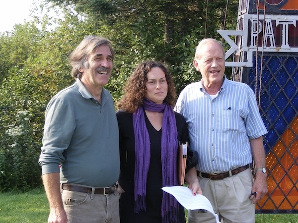
l-r: Kim Nilsen of the Cohos Trail Association, Gloriane Blais of Sentiers Frontiers, and Richard Andersen of the International Appalachian Trail.
Eleventh in a series of posts about a 2009 hike on the northernmost section of the Cohos Trail.
I saw a magnificently starry night last evening through the mesh of my tent. Awesome, in the original sense. It occurred to me this is the first time on the trip I’ve seen such a clear night sky. I’ve fallen asleep too early most nights, & it’s been cloudy on some others. I’ll treasure the memory of last night’s view, with so many more stars than I can ever see at home. I started identifying constellations, but quickly decided to forget that. I just stared up at the sky like a kid, with a silly grin on my face. I couldn’t even articulate a prayer of thanks beyond “…this is soooooo cool.”
Pete & Lainie picked me up at 8:25 this morning, accompanied by Kim Nilsen, the man behind the whole idea of a Cohos Trail. Today’s official celebration of the joining of the CT with a Canadian trail is something he’s wanted to see for a long time.
The press conference turned out to be quite an event, with a wonderfully festive tone. About 70 people were there. Half were hikers, there to begin a six-day hike arranged & sponsored by Sentiers Frontaliers. Of course, every Canadian there was bilingual, while we few Americans were trapped in English. There were no VIPs from either New Hampshire or the US Government, but our hosts welcomed a Canadian mayor and a prefect and provincial deputies. So now we have an international trail! It was a happy morning.
I have taken my trip during the year’s first official heat wave. Here at back in “downtown” Pittsburg, in the land of satellite TV, channel 9 is reporting that Nashua hit 96 today. I know I had two mighty hot days on US 3 yesterday & the day before. Today, I’ve been driven everywhere, so the temperature hasn’t affected me much.
Here in Pittsburg village, I’m in a comfortable little unit here on Main Street. I’m catching up on news & sports & weather. There’s a DVD player & a selection of discs, and I’ve picked one out for the evening. I’ll be able to call home tonight. I’ve hand-washed the bulk of my laundry, & pieces are draped here & there to dry. I shipped off the tent & assorted gear at the post office down the street. This has been a productive afternoon.
Channel 9 forecasts storms tonight and maybe early tomorrow. That should break the heat for now. Unless we’re in for all-day rain, I plan to put in however many miles it takes to get all the way back to the lodge where I started this hike. I’ll get a good breakfast at the diner up the street, and then I’ll be off. I’ve already called my host at the lodge to tell him I’m coming in a day early. I’m eager to get going. As my husband would say, I can smell the barn.