Three in a row: rail trails link Salem, Derry, & Londonderry NH

Recent walks and rides: Londonderry, Derry, and Windham. Each town has its own portion of New Hampshire rail trail on the old Manchester-Lawrence rail line. There are gaps, but the segments are being stitched together a bit at a time.

Windham Junction NH

These are paved trails. They’re like boulevards without cars. They’re high-traffic compared with most of their unpaved cousins, but they’re off-road and therefore safer than hoofing it down any local street. I just stay to the right, pass with care when I need to pass, and keep my speed down. (I never have trouble keeping my speed down.)

Londonderry

No sooner was the Londonderry trail extended to Harvey Road in 2019 than an informal parking lot took shape near the trailhead, doubling as an observation point for watching the planes at Manchester’s airport. I love that kind of efficiency. (Update, 2026: since construction of a culvert under Harvey Road for Little Cohas Brook, parking at that trailhead is a problem. Try the trailheads across from North Londonderry Elementary on Sanborn Road or the Park and Ride on NH Route 28 near I-93’s exit 5.)

On my most recent visit on a hot summer day, I was surprised by a gentle fragrance as Little Cohas Brook came into sight. I gave the credit to the blooming water lilies. Loosestrife was in bloom as well: lovely purple color on what I’m told is a highly invasive plant.

Little Cohas Brook, Londonderry rail trail NH
Along Little Cohas Brook, Londonderry rail trail. All photos by Ellen Kolb.

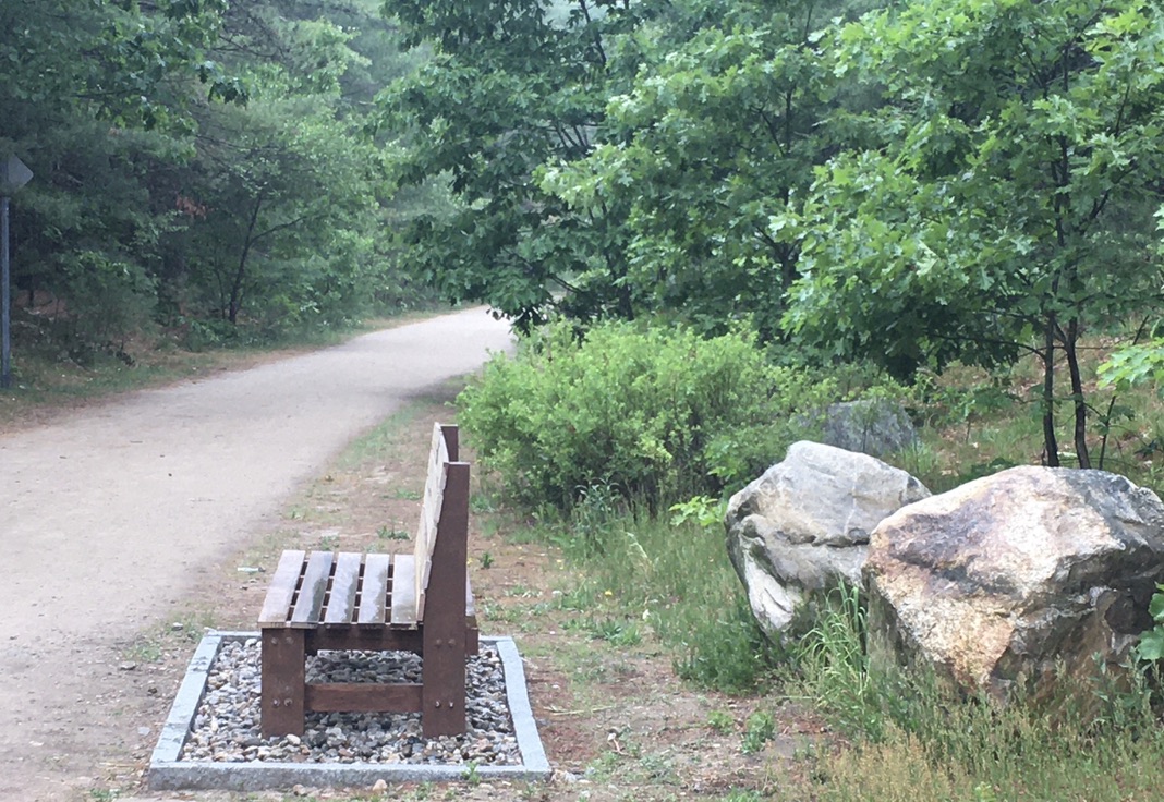
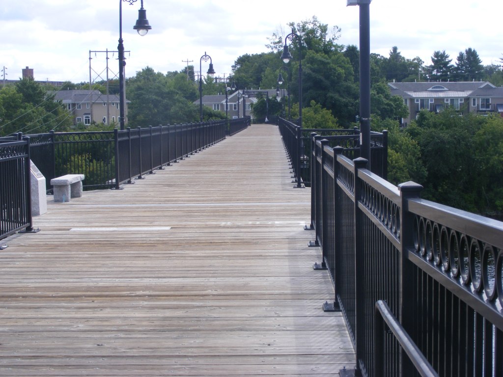
Busy as the trail can be, I had no sense of being crowded on my midweek visit. There was room for everyone. I even had a bench to myself for a bit of birdwatching.

bench along Londonderry rail trail NH
Benches are a bonus along rail trails.

I like seeing mile markers that have been restored or re-created. They keep me mindful of a trail’s history.

Mile marker, Londonderry Rail Trail NH
“L” for Lawrence MA, “M” for Manchester NH.

Four and a half paved miles extend from Harvey Road to the town line at NH Route 28. From the southern end, I could see across the road to a yet-undeveloped stretch of railbed in Derry. Its day will come.

Local trail group: Londonderry Trailways

Derry

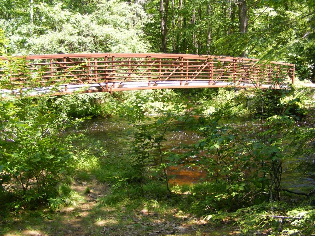
I spent a good afternoon walking on Derry’s trail that links Hood Park with Windham Junction. That’s about 8 miles round trip, with refreshments available from businesses near each end. Parking is available at both ends.

Derry rail trail NH
Lest I forget about social distancing, someone painted a reminder.

Nothing but an embankment and a strip of trees separated me from I-93 on the southern part of the trail. Once the trail and highway diverged, the scenery changed to wetlands full of red-winged blackbirds. Proceeding north, I entered residential areas, then passed a ball field, and crossed busy NH Route 102 in the center of town.

Crossing 102 was easier than I expected. Traffic actually stopped for me as I entered the crosswalk. That is not something I take for granted in central business districts, even on a weekend.

My favorite part of the trail paid tribute to poet Robert Frost, who spent a few years teaching at nearby Pinkerton Academy. “The Road Not Taken” had been stenciled on the trail only a day or two before my walk. More artwork has since been added.

Robert Frost poem on Derry rail trail NH
Frost’s “The Road Not Taken” is a Derry Rail Trail highlight.

Local trail group: Derry Rail Trail
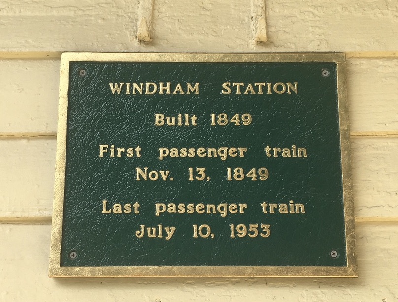
Windham

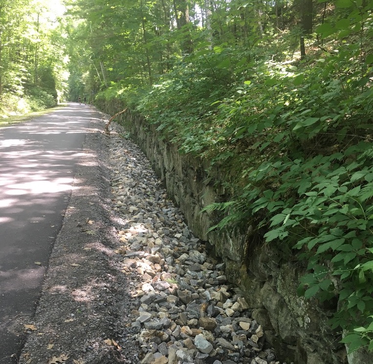
I confess to a special liking for the Windham rail trail. Even on the hottest day, it’s cool and restful.

Boston and Maine caboose, Windham Junction, NH
This Boston and Maine RR caboose is now a Windham Junction landmark.

Windham Junction, with its restored depot and caboose, has a good-sized parking lot. That makes it a good starting point for a ride or walk north into Derry or south into Salem. My recent trip was just to enjoy the Windham trail itself.

Windham rail trail NH
Roulston Road crossing (no parking here).

The trail looked practically freshly-pressed. Recent maintenance work has improved the trail’s surface and drainage.

Windham rail trail NH
New pavement, new drainage work, trimmed shrubs: welcome to Windham’s rail trail.

Local trail group: Windham Rail Trail Alliance

Beginning the NH Rail Trail Challenge: low-key, close to home

I can tell already that the Rail Trail challenge is going to figure into many future posts. I hope readers who are inspired by the challenge will share their own posts and photos so we can learn from each other.

I enjoyed a walk on the Goffstown rail trail a few days ago with Paula Bedard of the Bike-Walk Alliance of New Hampshire, of which the New Hampshire Rail Trails Coalition is an affiliate. If the Challenge has a prime mover and guiding spirit, she’s it. It was great to talk with her about our favorite trails and the shape they’re in.

Goffstown rail rail
Along Goffstown rail trail

She made an important point to me that makes me much more optimistic about earning that Challenge patch: participants must explore each trail, not travel every inch of every trail. Whew! OK, so I’m not just going to do a quarter-mile of the Northern Rail Trail and then check it off the Challenge list. But it’s good to know that an overgrown trail – northern stretch of Fort Hill, maybe? – won’t be a stopper.

The next day, at Paula’s urging, I picked up the second edition of Charles F. Martin’s book, Rail Trails of New Hampshire. The first edition has been my companion on many trips. With more trails developed and with conditions changing on existing ones, a new edition is timely.

Brookline, NH

Why go out of my way to check off anything from a trail list? In 2020, the only reason I need is that I am grateful for diversions from the challenges of COVID-19. I crave out-of-the-way places where no masks are required. Fresh air clears my head. A straight flat trail lends itself to prayer and reflection.

Brookline NH rail trail
The Brookline rail trail is unpaved but wide and suitable for bikes. Ellen Kolb photos.

All of which brought me to the Potanipo rail trail in Brookline, NH. The little town already has a place in this blog thanks to the Andres Institute of Art with its trails and outdoor sculptures. The rail trail is nearby. It’s short, straight, shady, and ideal for a brief respite from routine.

I parked off of Bohannon Bridge Road, next to a ball field, just past the Nissitissit River. Finding the trailhead for the developed part of the old rail line was easy. A runner was just returning to her car. A gentleman was walking his dog ahead of me. Farther along I saw a pair of friends laughing and walking briskly together. The trail might have been new to me, but clearly the locals were familiar with it.

Brookline NH rail trail
The Nissitissit river and the streams flowing into it are quiet in summer – but watch out during spring freshet.

The trail is about a mile long. The slow-moving river alongside is concealed this midsummer by heavy vegetation. The trail surface is unpaved but wide and smooth. There’s one road crossing. The trail peters out at NH Route 13, behind a gas station and a pizza restaurant. The parking there makes a convenient starting point for anyone who wants to go out-and-back along the trail from that direction.

After a hilly walk at the Andres Institute, the flat Brookline trail might be a good way to get the kinks out of those sore legs. 

New Hampshire Rail Trails: a friendly challenge

The New Hampshire Rail Trails Coalition has issued an imposing challenge: travel every rail trail in New Hampshire, and earn a patch. I love patches. I’m in.

Cheshire Rail Trail, Troy NH
Cheshire Rail Trail, Troy NH. Ellen Kolb photo.

Can I really cover all 300+ miles? I’ll have fun trying. Download the list yourself from nhrtc.org and see what looks tempting.

Reading the list is an eye-opener. I thought I knew about most of the trails in the state. But Head’s Pond in Hooksett? Nope. Lilac City Greenway, Cotton Valley trail, Fort Hill? Nope, nope, and nope.

I sense some road trips coming.

Hands Across the Merrimack Bridge, Piscataquog rail trail, Manchester NH.
Hands Across the Merrimack bridge on Piscataquog Rail Trail, Manchester NH. Ellen Kolb photo.

Already, since I’ve taken up the challenge, I have discovered new-to-me trails within a half-hour’s drive of my home. I’ve walked on some and biked on others. Many are well-shaded, which feels great during this hot summer.

I’ll be posting about some of my discoveries in the coming weeks. So far, these aren’t epic journeys. In stressful times, though, I don’t need “epic.” I’m happy to find a bit of beauty and recreation close to home.

Footbridge on New Boston rail trail, New Hampshire.
Footbridge on New Boston (NH) rail trail. Ellen Kolb photo.

Too Much Traffic: When a Park Gets Too Much Love

I’ll start with my conclusion: if the parking lot at your intended trailhead is full, keep driving. Please.

What’s happening in my own New Hampshire town is surely happening elsewhere, as the Covid pandemic affects outdoor recreation. A recent online meeting of the conservation commission, normally an under-the-radar board, drew plenty of viewers and plenty of questions (submitted in advance by email). Topic: what’s to be done with Wildcat Falls? (Update, 2025: the property is now called the Wildcat Conservation Area.)

Wildcat Falls is one of the main conservation lands in town with a trail network. It’s along the Souhegan River, not far from where I live. In ordinary times, the small parking lot can accommodate the manageable number of people who come to walk their dogs, birdwatch, or enjoy sunning themselves by the falls that give the area its name.

Then came the pandemic. The neighboring state of Massachusetts has been hit much harder than New Hampshire, and accordingly has had more restrictions on recreation. So did Massachusetts residents stay home and wait for things to clear up? No, they did not. (And neither would I, in their place.) They headed over the border and discovered some of the little southern New Hampshire parks I’ve been raving about for years.

That has meant a lot more action in Wildcat Falls. Combine our visitors with the locals who already love the place, and Wildcat’s being loved to death.

This conservation land is adjacent to a residential area. What happens when the visitor census explodes? The visitors to the conservation land park on the local streets, blocking driveways and fire hydrants, and narrowing the streets to the point where emergency access – say, by a fire engine – could be impossible.

The conservation commission meeting was specially scheduled to give people a forum to vent about the parking, noise, and public health problems created by the additional visitors. No decisions were made that evening. There were plenty of suggestions, though, ranging from “tow the cars” to “close the park.” I’m not sure from what direction a solution will come, but for now, I am avoiding the area and taking my walking shoes elsewhere.

The Forest Society is coping with the too-much-love phenomenon at Mount Major, one of their properties that is extremely popular anytime but has become a major (no pun intended) draw for people whose other recreational options have been limited. Aerial footage of the road leading to the parking lot has made me wince, with cars parked along the road as far as the eye can see.

The Forest Society, blessed with numerous properties statewide, has responded by publicizing some of its less-visited reservations as alternatives to the hot spots. Good solution.

New Hampshire State Parks have resorted to a reservation system for popular spots like Monadnock and Pawtuckaway. It’s a little grating to me have to go online for a parking pass in advance, but not as grating as having the parks closed altogether – which was the situation for awhile.

I have put serious mileage on my walking shoes since the Covid pandemic began affecting our health and blowing our routines to pieces. Getting outside has been absolutely essential to keeping me on an even keel. I get it: a lot of my neighbors, including my neighbors south of the nearest border, are in the same position.

But, please…when a trailhead parking lot in a residential neighborhood is full, let’s find someplace else to go. Quite aside from public health concerns, the neighbors will be grateful.

Update: a month after I wrote this post, the Merrimack Town Council voted after lengthy consideration to close the Wildcat Falls conservation area temporarily. The area has since re-opened as Wildcat Conservation Area, and additional parking is available at Watson Park, a half-mile away by trail.

Related: I wrote Keeping It Local with some ideas for finding less-traveled trails in southern New Hampshire.

Pawtuckaway State Park in Covid time: no crowds midweek

To call this an odd spring for hiking would be an understatement, thanks to the COVID-19 pandemic. I’ve heeded New Hampshire’s stay-at-home recommendation as much as I can bear, being old enough to be considered more at risk than younger neighbors. I have a homemade mask to wear on my few outings. I’ve Instagrammed and tweeted about #homehikechallenge. I’ve walked lap after lap on neighborhood streets. Boredom finally drove me out to Pawtuckaway State Park, where I hoped the extensive trail network would allow for the social distancing we’re all supposed to observe.

Pawtuckaway State Park, NH
At boat launch, north side of park.

More than boredom got me out the door. I was afraid that state officials might suddenly close down trailheads on state property. The U.S. Forest Service recently did just that in the White Mountain National Forest, citing excessive crowding and a lack of social distancing at trailheads. The WMNF trails are open, but the trailheads and campgrounds are not. (I envision hikers being dropped in via helicopter, but that’s probably against the rules, too.)

For the moment, the state parks are open, with some new restrictions on parking in popular parks like Pawtuckaway. (See nhstateparks.org for details and current information.) On my midweek visit, the restrictions seemed to be effective, with only a couple of dozen cars parked in the lot at the main entrance. Signs were posted in the parking lot and at trail junctions advising visitors to observe good hygiene and stay at least 6 feet away from each other. No problem for me, traveling solo.

boatrentals
Boat rental area near the Pawtuckaway Lake beach is deserted during “stay at home” recommendation.

The fire tower on one of Pawtuckaway’s three little mountains usually attracts me, but it usually attracts lots of other people, too. Scratch that idea. The black flies were out, and even with DEET I didn’t relish the thought of swatting them away for a few hours in the still air of the woods. Nope. I decided on a breezy route that edged Pawtuckaway Lake: the access road from parking lot to campground to lake, then the Fundy trail northward to the boat launch and back. Jackpot.

Burnham Marsh
Burnham Marsh, late April: things are beginning to green up.

However many cars were in the main lot, I saw only about 20 people during my seven-mile walk. That’s nothing compared to Pawtuckaway’s usual crowds. The visitor center was closed, and so was the campground and the boat rental station. The lake is usually dotted with kayaks and canoes in the coves, with powerboats making a racket in the open water. Not this time. The peace and quiet, odd at first, won me over pretty quickly.

trailhead NH Pawtuckaway State Park
Fundy Trail links Pawtuckaway Lake area with north side of park.

My friends and I have been joking about the “COVID 25,” meaning the weight we’re apt to gain with all the baking and cooking we’re doing during enforced time away from our usual activities. I hike for fun, but there’s an element of necessary exercise these days as well. My Pawtuckaway route was flat except for the slightest of inclines near the end, perhaps a couple of hundred feet in the last mile. I took that mile at the briskest pace I could manage without breaking into a jog. The COVID 25 was chasing me.

stone wall
Stone walls along the way – after all, this is New England.

I was in a familiar park under very unfamiliar circumstances, feeling ease and unease all at once. It was downright weird to be on those paths with so few people. Inside me is a spoiled child impatiently stomping her foot and demanding that the world get normal again. Yet under normal circumstances, I wouldn’t have had the lakeshore practically to myself.

I stopped at one point to watch three herons for awhile. No one else was in sight. The solitude suddenly felt right. It didn’t feel imposed on me.

glacial erratic
Glacial erratics are found throughout the park, calling cards of the Laurentide ice sheet from an earlier epoch. Backpack placed at base for scale.

A Covid challenge: keeping hikes local

For my readers in New Hampshire’s southern tier, itching for recreation as the COVID-19 pandemic turns everything upside down, this might be a good time to review the nearby spots where we can walk and decompress.

Go ahead. Get out there. It’s worth the effort to find an uncrowded place to walk. Aim for solitude instead of isolation (there’s a world of difference). Social distancing is important, and some of us need to stay extremely close to home, but don’t rule out every outdoor option. Remind yourself that it’s spring, even if this seems like a crazy time. The peepers are waiting for you. The pollen may have found you already.

Can’t get out now? Plan for future hikes. The current unpleasantness is temporary.

DSCF2279
Oak Hill Trails, Concord NH
  • What are your favorite spots in your own town? Are the trailhead parking lots full?Maybe there’s a new park to discover nearby. Look up Parks and Rec or Conservation Commission on your city or town website. You may find trail descriptions and maps available for download.  Maybe there’s a newly-acquired property you haven’t heard about yet.
  • Facebook and Instagram can be gold mines of information on current trail conditions. Follow or “like” pages such as Friends of the Goffstown Rail Trail and Londonderry Trailways (to give just two examples). You might find reports that one trail is experiencing too-heavy use on a particular day, while another one five miles away is much quieter.
  • The Forest Society has more than a hundred properties statewide for you to discover. Forget the one on Mount Major, where the parking lot looks like a mall on Black Friday. That still leaves a bunch of beauties, and there’s probably one near you. Website bonus: virtual tours, where you can check out properties online and plan for future hikes.
  • There’s probably a New Hampshire state park near you. There might be some access limitations.
  • This isn’t the time to push any physical limits. First responders have enough to do at the moment without fetching injured hikers.
Stratham Hill Park, Stratham NH: a guide to what you can see from the observation tower.

Are you avoiding even solo road trips? Join the club. I’m lucky to have a walkable neighborhood: no sidewalks, but no through-roads, either. That’s where I’ve done most of my walking for the past couple of weeks. I find that a daily walk is an absolute necessity, not so much for the physical exercise as for the mental shift.

Bonus for the soul: I’m seeing neighbors I’ve never met, who are also trying to fight the shut-in feeling that comes with these days. We observe social-distance protocols. The six-foot rule does not bar smiles and greetings.

sculpture in white granite
Mbari House by Geoffery Nwogu, one of many sculptures along the trails at the Andres Institute of Art, Brookline NH. 

Traditional school’s out, gyms are shut, businesses are closed, paychecks may or may not be forthcoming, and #stayhome is trending. My walks are a refuge from all that. 

ruins of stone house in a forest
Madame Sherri Forest, Chesterfield NH