Early fall, Northern Rail Trail

If the Danbury Country Store were a human being, it would be my new best friend. This and other treats awaited me as I set out on a long walk on central New Hampshire’s Northern Rail Trail.

Fifteen miles is a big stretch for me, especially after losing fitness and energy to post-Covid problems earlier this year. I had to crawl, figuratively, before I could walk far again. I’ve added a few more miles each week. This week, I decided to go big. I walked on the trail from Potter Place in Andover to the Danbury Country Store and back. I figured that was one way to evaluate how I’m doing.

I’m doing fine. Sore, yes, but fine.

Sights

I’d seen Potter Place before, but its charm catches me by surprise every time. The restored depot in Andover close to the US 4/NH 11 junction is a tribute to the people who care about the rail trail and the railroad’s history. The Northern Rail Trail is in fact well-loved and well-maintained throughout its fifty-plus miles. A big park-and-ride lot just down Depot Street from Potter Place is an ideal spot from which to launch a walk or ride along the trail.

 railway car and restored train depot
Potter Place: restored depot and an old Central Vermont Railway car. All photos by Ellen Kolb.

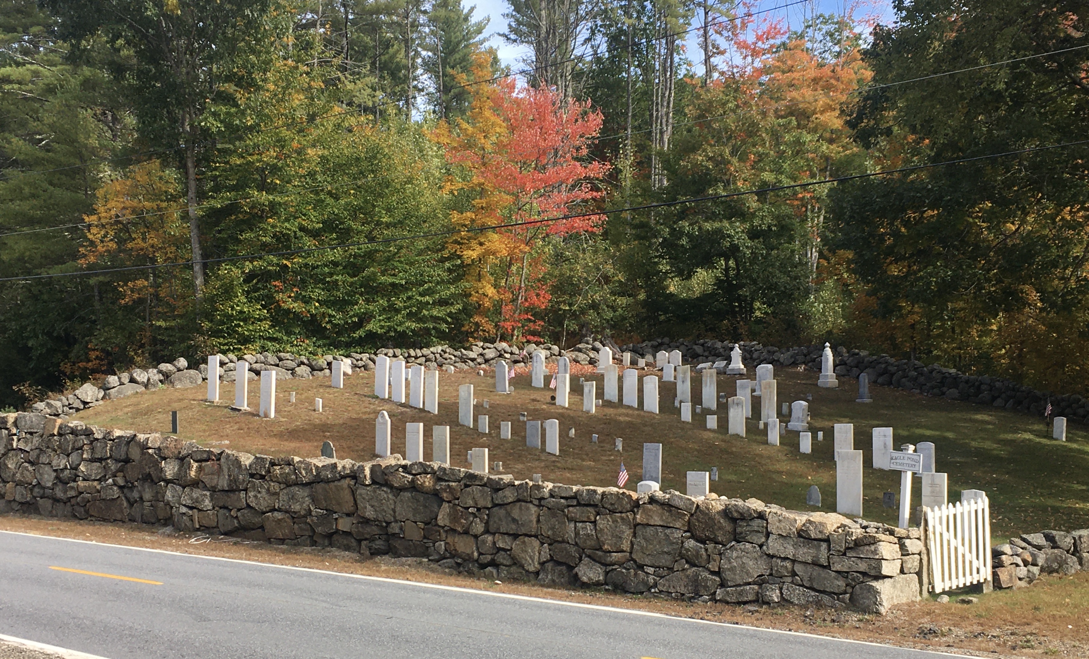
Coming upon an old cemetery is no surprise on any of my walks. In Wilmot, I came upon one that looks beautifully tended. From a distance the markers looks unweathered. They’re all upright. The stone wall around the cemetery is a work of art, albeit with some interesting items (read: “trash”) tucked between some of the stones.

small cemetery with upright stones, surrounded by stone wall with fall foliage in the background
Eagle Pond Cemetery, Wilmot

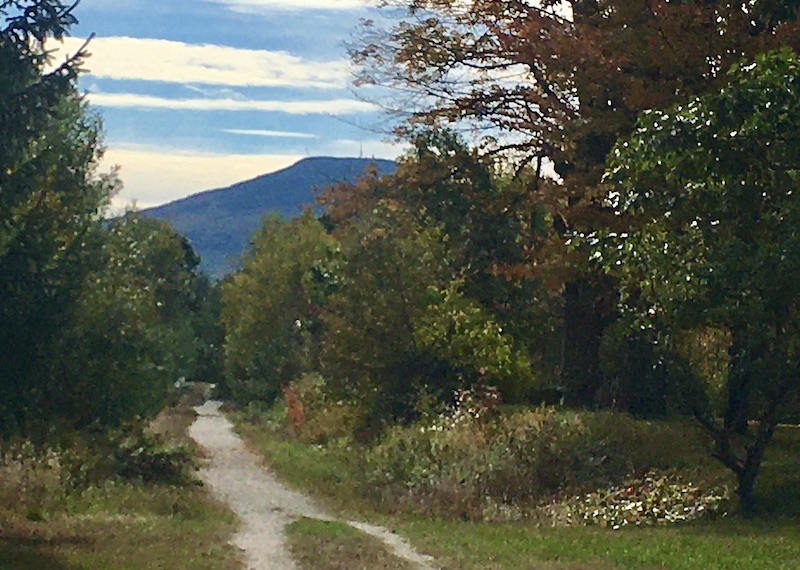
I even got a glimpse of Mt. Kearsarge. I took a photo that came out fuzzy, but even so one can barely discern the cell tower on the summit, with the fire tower just to its right.
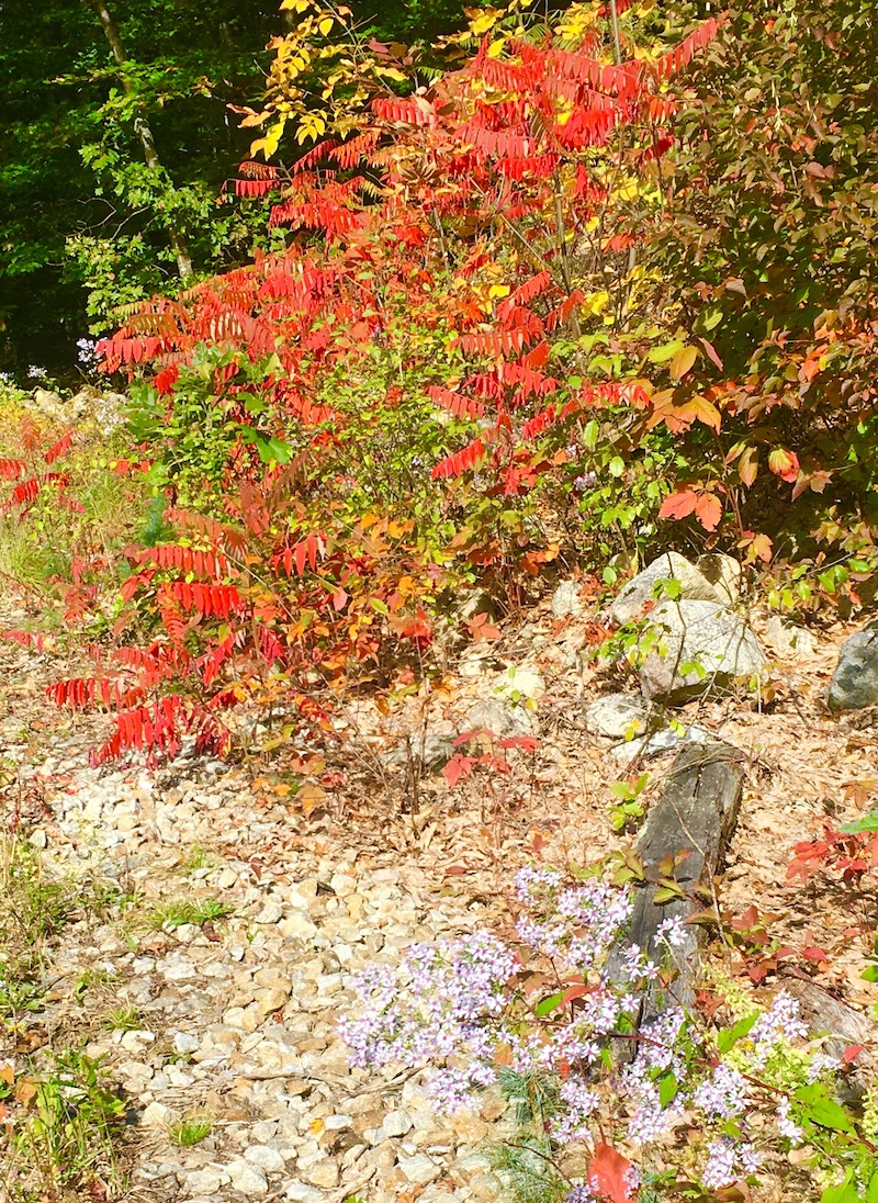
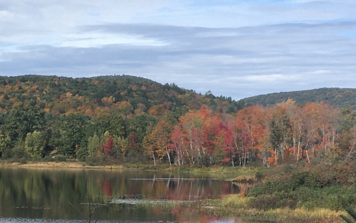
unpaved trail through a forested area with a mountain in the distance
Mt. Kearsarge seen from Northern Rail Trail

Foliage

Fall is my favorite time to take walks, and even the weeks before peak foliage can be splendid. I found plenty of leaves underfoot this week. Remaining foliage in the central New Hampshire area I visited is still a week or two away from full color. Icy blue asters, a last reminder of summer, persist all along the trail, contrasting nicely with the changing leaves.

shrub in fall foliage
Tiny blue flowers in the foreground contrast nicely with the changing leaves.
pond surrounded by trees in autumn foliage
Eagle Pond in Wilmot

Lunchtime

My turnaround spot was the Danbury Country Store. It’s a must for anyone traveling along the NRT. I figured I’d sit on one of the porch seats there and nibble on a Clif bar from my pack. That was before the store’s deli crew set out two fresh hot pizzas. Game, set, match, and the Clif bar retreated to its pocket.

Also at the store: an air pump for cyclists, a huge assortment of beverages, the usual country-store inventory, and a deli where you can have any sandwich made to order. Enjoy. I sure did.

As I write this the day after my walk, I’m nursing a few aches, but they’re good aches. The kind that don’t herald injuries; the kind that whisper please don’t try this two days in a row. Best fifteen miles of the year, and that’s good to write three months after I needed my husband’s help to get around the block.

Fall isn’t winter’s knock on the door. Instead, winter is the price I pay for fall hiking. Fair exchange, in my view.


Finding something new on the familiar Nashua River Rail Trail

How did I not see this before? It’s a granite marker along a trail crossing the New Hampshire-Massachusetts border, plain as day. Somehow, I had never seen this, even though I have walked this trail maybe a hundred times.

I saw that there was a knocked-over lightweight fence nearby; had that concealed the marker all these years? Or have I just not been paying attention?

Years ago, I first saw markers like these along the Wapack Trail. I noticed that the letters referred to the town I was in as I looked at the marker, not the town I was about to enter. Having spent more time on interstate highways than on trails, this surprised me, but I’ve since gotten used to it. It’s remarkable to see these markers in such good shape after more than a century.

Anyone looking at my walking history can see that there are a few paths and parks to which I return again and again. There’s a sort of comfort and ease in being someplace familiar. This marker reminds me that it’s good to stay as alert on such trails as I am on new ones. Little delights abound, if I pay attention.

Short climb, grand view: Mt. Kearsarge via Rollins State Park

My last visit to Mt. Kearsarge in Warner, New Hampshire was a few years ago, as the fire tower was being rebuilt. I recently decided to go back for my first uphill walk since the virus-in-the-news laid me low earlier this year. From the upper end of the auto road in Rollins State Park, which is a treat in itself, I hiked the half-mile-long Rollins trail to the Kearsarge summit.

fire tower on Mount Kearsarge in Warner, New Hampshire, accessible from Rollins and Winslow State Parks. Photo by Ellen Kolb.
Mt. Kearsarge fire tower, Warner NH. Ellen Kolb photo.

It was a splendid morning at the end of August. A muggy summer heat wave had just broken, giving way to clear dry air and brisk breezes. As self-imposed rehab assignments go, this hike was unbeatable.

Summit cairn, Mt. Kearsarge. Ellen Kolb photo. Twin hills in far distance at left are the Uncanoonucs in Goffstown NH.

The hills and trails of southern New Hampshire spell home to me. I looked south from Kearsarge’s summit cairn and scanned the horizon: the Uncanoonucs in Goffstown, Joe English hill in New Boston, a view of the Wapack Range from the north – is that Crotched Mountain ski area nearby? – and aloof and stately Monadnock.

The ledgy summit features a 360 degree view, in case someone finds the view of the southern hills unsatisfactory. My advice is to soak it all in.

At $4, park admission is a bargain. See nhstateparks.org for up-to-date information on fees and maps for this and other state parks. Kearsarge is home to two of those parks. Rollins from the south features the auto road and a short hike; Winslow from the north offers longer trails. The Sunapee-Ragged-Kearsarge Greenway makes its way over the summit as well.

The auto road closes to motor-vehicle traffic in November and usually re-opens on Memorial Day weekend. I enjoy walking on the auto road in the off-season when the weather allows, sharing the road with other walkers and ambitious bicyclists. The summit is out of reach for the likes of me until the snow and ice are gone, but there are a few vistas along the auto road that make an uphill walk worthwhile.


Public Art Enhances Rail Trails

Murals, sculptures, and illustrations on the pavement could await you when you discover New Hampshire’s rail trails. Some trails feature artwork provided by volunteers from local trail groups. Others display the colorful contributions of area students or professional artists. As you walk or ride along the trails (find a complete list at nhrtc.org), look for treats like these.

Poet Robert Frost once taught at Derry’s Pinkerton Academy. The paved Derry Rail Trail pays tribute with an illustrated version of “The Road Not Taken,” one of Frost’s most famous works. The trail surface itself serves as canvas for this imaginative project.

Read the rest of the post at the New Hampshire Rail Trails Coalition blog.

Derry Rail Trail (NH) tribute to Robert Frost
The Derry Rail Trail features a tribute to Robert Frost with an illustrated rendering of “The Road Not Taken.” Photo by Ellen Kolb.

Safety first for Derry NH Rail Trail

Update, 2026: Three and a half years after the post below, after a lengthy period filled with public hearings and litigation, a settlement was reached that requires the New Hampshire Department of Transportation to use the tunnel plan recommended by trail advocates as NHDOT proceeds with construction of the Derry Rail Trail Tunnel as part of the expansion of Exit 4A on I-93.

I wrote about the impressive cooperative effort at “Better Together: non-motorized trail users speak up” (2/10/2026). See also the reports on the New Hampshire Rail Trails Coalition site: “It’s Official – the Derry Rail Trail Tunnel to be Built!” (2/11/2026) and “Big Win for NH Rail Trails” (2/12/2026).


The Granite State Walker is about celebrating New Hampshire trails – not the mountain trails that are well-documented elsewhere, but the southern New Hampshire trails that deserve to be just as cherished. Public-policy advocacy is not the usual beat for this blog. Something is coming up that prompts me to make an exception, and it involves the Derry Rail Trail.

Derry’s trail is part of what will someday be the Granite State Rail Trail, extending from Salem to Manchester and beyond. Already, the Derry trail connects with the Windham Rail Trail to the south, and it will eventually connect with the Londonderry Rail Trail to the north. One important segment yet to be built is the trail’s crossing of the proposed exit 4-A on I-93.

In brief, the state Department of Transportation intends to route the rail trail along a messy path, aptly nicknamed (not by the DOT) the “spaghetti route.” This is far different from the original plan, which was a simple tunnel routing the rail trail under the highway. The tunnel plan is safer and simpler.

What to do

On Thursday, August 4, the Department of Transportation is holding a public meeting at 6 p.m. at West Running Brook School in Derry. The purpose of the meeting is to present the DOT’s preferred plan to the public. It’s unclear how much opportunity there will be for public input. That’s not going to stop advocates for pedestrian and bicyclist safety from making an impression simply by showing up. [Note that the NH Department of Transportation later rescheduled the meeting to Thursday, September 22. The August 4 meeting was postponed due to hot weather. I wrote at the time “One might call that a safety concern. Let’s hope the same concern animates future moves in the Exit 4-A project.”]

Attend if you can, wearing something that’s a bright “safety yellow” color. The New Hampshire Rail Trails Coalition’s Facebook page has more information about the meeting. (Full disclosure: I’m on the NHRTC board.)

Improve I-93? By all means. Build exit 4-A, which has been in the works for years? I’m OK with that. Let that project advance the safety interests of all transportation users, not just drivers. The tunnel plan would do just that.

Proposed exit 4-A project, showing Derry Rail Trail proposed path: brown line indicates the tunnel plan, while the blue line indicates the more convoluted plan favored by NHDOT. Image from Bike-Walk Alliance of New Hampshire (bwanh.org)

For more information

The Bike-Walk Alliance of New Hampshire has a helpful information page that includes illustrations and narrative descriptions of each of the proposed plans.

BWANH’s conclusion is right on target: “New Hampshire will be stuck with the outcome of this project for many years to come. Let’s get it right, and do it right the first time.”

Visit the trail now

You don’t have to wait for the completion of the Derry Rail Trail to enjoy the segment that’s open now. Start from Windham Junction and head north on the paved trail. You’ll see and hear I-93, but soon the trailside wetlands with their birds and flora will capture your attention. Watch along the way for the artistic tributes to poet Robert Frost, who once taught nearby. As you approach NH Route 102 in central Derry, plan a stop at one of the businesses that support the trail, such as The Grind coffee shop.

All along the way, remember: safety first.

pond at Hood Park, Derry, New Hampshire
Hood Park in Derry NH, seen from Derry Rail Trail. Ellen Kolb photo.

Sharing the wealth: open land in New Hampshire

I grew up in south Florida, in a pleasant but crowded neighborhood filled with houses on eighth-of-an-acre tracts. “Open land” to me meant the local playground. I came to New Hampshire as an adult and found a very different culture. People who owned land, were not developers, and were happy to leave their property open to hikers: imagine that! On many of my walks over the years, I’ve been blessed by landowner generosity.

This came to mind not long ago during a walk in Concord that brought me to a gated road at the edge of a school’s property. The school is famous and expensive, with a campus to match. It’s a small town unto itself. I was once invited to speak to a class at the school, and I nearly got lost trying to find my way around. Never mind the buildings, though, impressive and numerous as they are. The best thing about the campus is its open land, the green spaces.

dirt road in a forest with an open gate
Private land, limited public use: sharing the wealth. Photos by Ellen Kolb.

Almost as good: the school’s choice to welcome visitors who simply want to enjoy a walk through the property. Signs are posted along the road: “Walkers, joggers, and cyclists are welcome to enjoy these grounds in a safe and appropriate way.” No checking in, no showing ID, just behave yourself.

I had been to the campus for a few winter walks, taking advantage of clear sidewalks and light traffic on icy days. My recent visit was in summer, when the campus wears a different aspect. I chose to explore a road leading to the school’s boathouse on a nearby pond. As it stretches away from the main campus, pavement gives way to gravel, and the trees in full leaf offer shade all the way to the pond.

Few flowers were growing in the shade. Other vegetation – trees, shrubs, grasses – was thriving in spite of the region’s drought, muting the traffic sounds from the nearby interstate highway. I struggled to identify birds by their songs; their music was everywhere but the birds were hidden in the trees. For once, I had no schedule to keep. I had stumbled onto what I consider pure gold: a path all to myself on an unhurried midweek local walk.

New Hampshire pond with one canoeist and a wooded shoreline
If only I’d had a kayak!

Coming out of the woods at road’s end, the pond gleamed in the sunshine. I could see the highway from there, and I knew that a paved bike path on state-owned land lay on the highway’s other side. Was there a connector? With no “keep out” signs to discourage me, I kept walking. The dirt road dwindled to a path and then to a rough trail…and yes! I walked under the highway on a path that I’m certain is as unofficial as it is locally popular. Soon, I was on the bike path paralleling the highway.

There, I was in full sun. I brushed against oxeye daisies, fireweed, and clover too wild to be controlled by any mower. I didn’t mind the traffic noise; it was the price of admission.

I got back to my car a little over an hour after I’d left it. I’d managed to cobble together a loop featuring the best of the season’s shade and sun. I’m grateful to the stewards of the bike path, and just as grateful to the stewards of the private school’s land. It’s good to be welcomed.

Oxeye daisies and butterfly
Oxeye daisies and their tiny visitor.