Winter games are here: snowshoes!

Mine Falls Park after first snowfall, December 2013

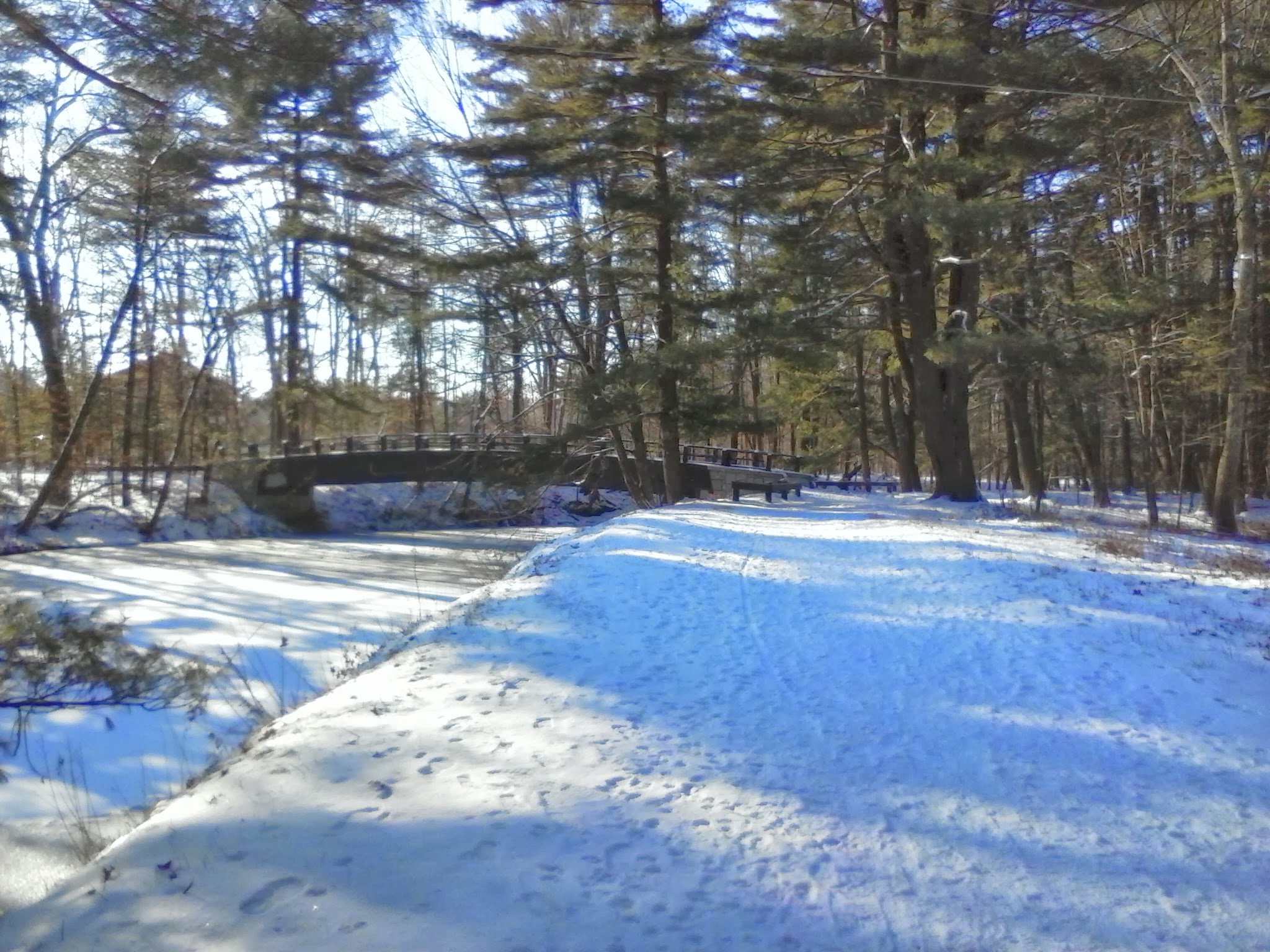
In mid-December, there’s finally been a snowfall in southern New Hampshire just heavy enough to put a base on the trails. It’s late fall, and winter is impatient to elbow its way in. This morning I spent an hour at Mine Falls Park in Nashua enjoying the crunch of snow beneath my sneaker-clad feet. The canal is almost-but-not-quite frozen over, and the muskrats have taken refuge wherever muskrats like to go.

Sometimes the season’s first snow pounds us. The Halloween Eve snowstorm in 2011 dumped a foot of heavy wet snow, uprooted countless oaks & maples, and left me without electricity for four days. Other years are more like this one, with a couple of tentative snowfalls, just to get us ready for the inevitable big ones.

I can pull my snowshoes out of their little nook in the basement and put them closer to the door.  I can look forward to hiking on those brilliant cloudless days that follow snowstorms. My favorite cross-country ski area has announced that it’ll be open for business this weekend, which means that their snowshoe trails are ready to go as well. A prime memory for me is a midweek trip there a few years ago, the day or two after a storm. There were a few skiers around, but I was the only snowshoer in sight, and I had all that wonderful powder to myself on the woods trails. Solitude, beauty, sunshine, and unbroken powder: does it get any better in the winter?

When the Olympics are broadcast shortly, I will ooh and ahh over the alpine skiers. I’ll cheer for the cross-country skiers, who are better-conditioned than most of us could ever hope to be. I’ll watch the snowboarding, which for my money is the most fun event to watch at the Olympics. But eventually, I’ll tire of being a spectator. The snowshoes will be right by the basement door, waiting for me.


Purgatory Falls, Lyndeborough/Mont Vernon, NH

water cascading over granite ledge
Purgatory Falls (Ellen Kolb photo)

I recently made it to one of my area’s more popular trails for the first time in ages. It’s another one of the southern New Hampshire treasures easy to take for granted.

When a late start forced a friend and me to change our plan to hike upstate last week, she suggested lower Purgatory Falls as a nearby hike that we could enjoy with her dogs. Sounded good to me. We started at the lower end of Purgatory Brook, at the trailhead on Purgatory Road in near the Milford/Lyndeborough town line a short distance north of North River Road. We had very little company, but my friend assured me that it can get crowded on weekends and in warmer weather.

I’m not used to hiking with dogs, and my friend brought her black Lab and her Shar-Pei. Both dogs were familiar with the trail and could hardly wait to jump out of the car at the trailhead. We decided to use leashes at first, until we were sure no other dogs were around. The Shar-Pei walked me – I can’t pretend I was controlling the dog! He was a calm and poky thing compared to his fellow pup, though. Maggie the Lab ran ahead of us, around us, into the brook and back again. A good time was had by all.

We took an hour to get to the upper Falls via a gentle uphill trail, but that was with plenty of doggie diversions. The walk back to the car was quicker, with the dogs a little less rambunctious.

I have relatives living in the village near upper Falls, and they once took me on a walk (a Thanksgiving day, as I recall) to see that spot. The walk from the village along unpaved Upham Road took us past the Purgatory Falls Fish and Game Club, at which point the road became a clear trail. It’s pleasant any time of year, I’m sure, although I’d pack the usual bug repellent in spring or summer.

Information about the northern end of the trail (upper falls) is on the Mont Vernon town web site.

Welch-Dickey loop, late October

Welch Mountain, taken from Dickey Mountain

Last weekend, I headed with a friend to the four-mile loop trail over Welch and Dickey mountains (elev. 2605 and 2734), with a trailhead off NH Route 49 a short distance west of Waterville Valley. This is a well-traveled trail, mentioned in guidebooks as being great for families. I tried to imagine how crowded the parking lot must be on summer weekends. This is fall, though; the leaves are past peak and the morning temps are in the thirties or lower.  There were only three other cars in the lot Saturday morning, assuring us a crowd-free day.

Despite umpteen operations on her knees, my companion was indefatigable, besides being a great deal  more fit than I am. She refused to be discouraged by my slow pace and overall wimpiness on hills. We had a great time. With stops along the way, including repairing a cairn I accidentally stumbled into, it took us about four hours to complete the hike.

We were greeted on the summit ledges by a trace of flurries. There was just enough snow in the air to hint that fall might give way to winter someday. Views from both peaks made me want to cheer, even with mountain slopes clothed in fading foliage.

I leave a detailed trail description to the guidebooks that are readily available. My friend had an AMC book with a description of Welch-Dickey, while I had Daniel Doan’s Fifty Hikes in the White MountainsThe trailhead is in White Mountain National Forest, and there’s an iron ranger in the parking lot to receive the modest day-pass fee. There’s a very clean pit toilet there, too, which is always a plus.

Pondicherry Wildlife Refuge, New Hampshire: tell a friend about it

A friend and I have been trying for several weekends to arrange a hike, with last-minute work commitments sabotaging every trip so far. Still, we keep planning. When I suggested Pondicherry Wildlife Refuge, she said “where’s that?” I was going to refer her to a blog post here, when I discovered to my embarrassment that I hadn’t yet written about this lovely place, despite my fondness for it. Oops. Making up for lost time here.

The refuge straddles the towns of Jefferson and Whitefield. To get there from southern New Hampshire, I take I-93 through Franconia Notch and then U.S. 3 through Twin Mountain into Whitefield. There’s a airport sign in Whitefield pointing me to a right turn off route 3. A drive around the south side of the one-runway airport brings me to a little biomass plant, across from which is a well-marked parking area for Pondicherry.

Mount Martha, with Presidential range at left. All photos by Ellen Kolb.
Cherry Pond, with Presidential range at left and Mount Martha at right. All photos by Ellen Kolb.
trailhead, Airport Road
Pondicherry trailhead, on Airport Road in Whitefield.

From the parking area, one could be forgiven for thinking “is that all there is?” The Presidential Rail Trail extends north from there, looking like a long dirt boulevard. (In fact, it’s a busy snowmobile thoroughfare in the winter.) Cherry Pond is a mile and a half away via the trail. During my April visits, little spring flowers are usually peeking up on the sunny side of the trail when there’s still ice along the shaded side. I seldom have company here, and there is little noise except for the occasional small plane landing at the airport.

The walk into the refuge is tree-lined, making the sudden view of the Presidentials all the more startling when I arrive at Cherry Pond. I never get tired of that view.

Nearby are Little Cherry Pond and the adjacent wetlands. The Cohos Trail passes through, piggybacking on the Presidential Rail Trail for some distance. There’s an observation platform, affording excellent views for the birdwatcher who remembered to bring her binoculars. Critters of all sizes, from beaver to moose, find Pondicherry a congenial place.

An active (but not busy) rail line runs through the property as well. I sometimes see a few freight cars parked on a nearby siding. This quiet location still bears the old rail-line name Waumbek Junction.

Pliny Range, north of Cherry Pond

The Pondicherry refuge is a cooperative venture of state, federal, and private organizations. A good guide to the Pondicherry trails can be found in the Jefferson Dome chapter of Kim Nilsen’s book 50 Hikes North of the White Mountains.

Update, 2026: Since I wrote this entry, Pondicherry Wildlife Refuge has found its way into many of my posts. I describe a recent visit in “One way to celebrate, part II,” with summertime photos.

Pawtuckaway via Deerfield Fair

Given a complimentary pass to Deerfield Fair, I decided to enjoy not only the fair but also nearby Pawtuckaway State Park.  It’s early fall, cool but not yet cold. The leaves are just beginning to turn around here. It’s less than an hour’s walk from the quiet northwestern edge of the park to the fire tower on south Pawtuckaway peak.

First fall colors at the edge of wetlands on Tower Road.

First fall colors at the edge of wetlands on Tower Road.

I hiked in from the northwest corner of the park on Reservation Road, far from the busy main entrance.

I hiked in from the northwest corner of the park on Reservation Road, far from the busy main entrance. The little blue asters were the only blooms in sight.

Pawtuckaway fire tower. Barely visible on the underside of the cab are charts describing the landmarks in each direction.

Pawtuckaway fire tower. Barely visible on the underside of the cab are charts describing the landmarks in each direction.

View from fire tower east to Pawtuckaway Lake and the Seacoast.

View from fire tower east to Pawtuckaway Lake and the Seacoast.

View to northwest; Mt. Kearsarge in distance.

View to northwest; Mt. Kearsarge is barely visible in the distance at center.


Enter your email address to subscribe to this blog and receive notifications of new posts by email.

Celebrate Ten Years of Connecticut Lakes Headwaters Conservation in NH

East Inlet, Pittsburg NH.

East Inlet, Pittsburg NH. Photo by Ellen Kolb.

Some years back, the decline of New Hampshire’s North Country paper industry left up in the air the future use of over 100,000 acres in Coos County. Conservationists got busy in an effort to protect the land for recreation and forest management. A serious team effort resulted in the Connecticut Lakes Headwaters Working Forest in 2003. Time to celebrate the first decade!

Head to Lake Francis State Park in Pittsburg (get on U.S. 3 and just keep heading north) on October 5th for the big event. The Department of Resources and Economic Development – and has there ever been a worse acronym than DRED? – is hosting lunch and a few speakers at 11:30 a.m. At 1:30, the real fun begins. Attendees can choose from six tours, each in a different part of the CLHWF, lasting until 4:30. For more information, or to RSVP, email Eric Feldbaum at eric.feldbaum@dred.state.nh.us. With your RSVP, be sure to specify your choice of tours.

Want to hear about the Cohos Trail, and walk on a short segment? Yes, I know I write about the CT a lot. You can find out why if you join Lainie Castine after lunch on the 5th.

Maybe you like fire towers instead. If so, head to Mount Magalloway. Forty-five vigorous minutes on the trail will reward you with views that will knock your socks off.

Have you ever been to Boundary Pond? Here’s your chance to see it, if you’re ready for a drive; the boundary in question is with Canada. Other afternoon options include kayaking, a timber harvest forestry tour, and a local-history lesson. I wish I could head north for the event, although I’d have a hard time choosing just one afternoon activity. I encourage you to make the trip, if you are anywhere near northern New Hampshire. Again, let me mention that address for RSVPs, so the organizers know how many people to expect: eric.feldbaum@dred.state.nh.us

Yes, I love the Connecticut Lakes. My photography doesn’t do the place justice. I hope you can take your own photos there someday.

First Connecticut Lake and Mount Magalloway, from Prospect Mountain. Photo by Lainie Castine.

First Connecticut Lake and Mount Magalloway, from Prospect Mountain. Photo by Lainie Castine.

River Road covered bridge, on the way to Lake Francis SP. Ellen Kolb photo.

River Road covered bridge, on the way to Lake Francis SP. Ellen Kolb photo.

Sunset, Cedar Stream Road. Ellen Kolb photo.

Sunset, Cedar Stream Road. Ellen Kolb photo.


Enter your email address to subscribe to this blog and receive notifications of new posts by email.