I was on the Nashua River Rail Trail for a few miles this weekend. I couldn’t help noticing freshly-cut logs and branches along both sides, thanks to volunteers I’ll probably never meet. Breezes and recent heavy wet snow had brought down trees all over the place. On the northernmost stretch of NRRT, the mess is cleared. All I had to toss aside were a few small branches.
Nashua River Rail Trail: winter winds brought down a tree, and volunteers cleared away the mess. Fence-mending will wait.
Not so upstate at one of New Hampshire’s largest ski areas which I recently visited. It’s one of the few ski areas in the state with a decent system of trails for Nordic skiers and snowshoers. While the resort’s management is understandably focused on the downhill ski trade (that’s where the money is), there’s not enough staff to keep the snowshoe/fat bike trails cleared, at least not yet this season.
I’ve kept an eye on websites reporting on New Hampshire rail trail conditions. Many of the rail trails are much longer than NRRT and have that much more of a mess to clean up. Enter the snowmobile clubs: I’m aware of two in particular in the southwestern part of the state that put out calls for volunteers for workdays this weekend. I’m sure that snowmobile clubs all over the state are doing the same thing, as pretty much every region got hit by storms over the couple of weeks.
Those clubs are doing work that will make walks much easier for me year-round, not just in winter. Grooming snow, clearing deadfall, and mowing grass take time and equipment and volunteers. I like walking alone, but some of the most enjoyable trails I know wouldn’t be accessible or pleasant without the work of many people. My solo walks benefit from teamwork.
Want to say thanks to the snowmobile clubs? Send a donation, even if you’re not a member. Include a note saying that you’re a grateful hiker. The New Hampshire State Parks website provides a list of clubs, and you can look up a club’s social media accounts (usually updated much more frequently than websites) to find contact information and to keep track of opportunities to volunteer for trail work.
My winter walks thus far have mostly been close to home, in neighborhoods and municipal parks. Those routes could use post-storm help, too. Your town’s parks and rec department or conservation commission might put out a call for volunteers on specific cleanup projects. Be on the lookout for such announcements.
And if you happen to come across some folks doing trail maintenance while you’re out and about, stop to say thanks.
New Hampshire’s mud season is here, thanks to a month that has brought days of snow alternating with days of 50 degrees. I went to the forest trails in one of my favorite Concord parks the other day, and I turned around after about a hundred yards. Squishy ground is not ideal for hiking. Turns out hiking isn’t ideal for squishy ground, either. Ask any trail maintainer. I’m switching to pavement for the time being.
March 2022: Nashua River Rail Trail, Dunstable MA. Clear pavement, muddy edges.Ellen Kolb photo.
While I’m putting in the miles on roads and paved trails, I’ll be giving some thought to the maintenance work and spring cleanup that will be going on as the weather gets warmer and the mud dries up. This is a good time for trip planning, too.
I serve on my town’s conservation commission, on a subcommittee dedicated to one of the town’s nature preserves. We’ve been keeping an eye on some areas being taken over by invasive plants that are crowding out native species. In consultation with an expert from the local university’s extension program, we’re coming up with a management plan to tackle the invasives later in the year. Planning now will pay off later.
My favorite local paved trail, the Nashua River Rail Trail, has obviously seen recent work from volunteers who have already made the most of mud season. While the side paths in the woods are still muddy and soft, working on the pavement is easy. Between my last two visits to the northern section of the trail, a crew or crews had been through to clear away fallen branches and pick up trash.
I’m gathering trail information this month for a multi-day hike later in the year on the rail trails in the southwestern part of New Hampshire. I don’t feel quite so stuck during mud season when I know there’s a trip ahead to plan and train for.
Mud season might give you time to learn more about the trails in your area, even if they’re temporarily off limits until things dry up a bit. Is a trail owned or managed by your town? Check with the Parks and Recreation department or the municipal Conservation Commission to find out if there are opportunities for you to volunteer for upcoming events. Are you fond of a certain rail trail? The New Hampshire Rail Trails Coalition website contains links to many local trail clubs, each with its own projects and schedule. Don’t dismiss Facebook; it’s still a great way to find groups organized around a specific trail or park. Those Facebook groups are often the best source of information on up-to-date trail conditions and maintenance needs.
Avoiding the trails for another couple of weeks will be good for them. Using the time for planning ahead will be good for me.
I wrote last October about a layered trail: ice, mud, and leaves underfoot. That’s pretty much what I’ve found in January in southern New Hampshire, minus the leaves. Things are pleasantly messy, as long as I have some traction on my shoes. Yes, even for the flat paths: slipping on an icy flat trail in Mine Falls Park left me with a concussion a few years ago. That’s one winter adventure I don’t care to repeat.
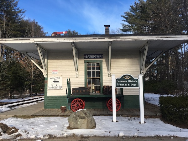
Rockingham Recreational Trail in Sandown; Sandown Depot. Photos by Ellen Kolb.
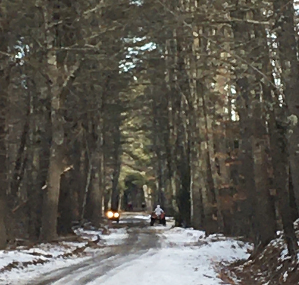
I was in Sandown the other day, sharing a trail with some polite ATVers. The trail wasn’t so much layered as patchy: ice here, slush there, frozen tire tracks in the shade, and lots of mud down the middle. I accidentally hit on the best time of day to be a walker there, mid-afternoon, after most of the ATVers had finished for the day. Not every multi-use trail works out so well for me.
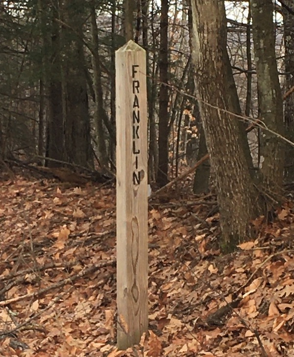
Not every trail gives me town line markers. I like it when the markers agree with my GPS.
A short drive north: the Northern Rail Trail follows the Merrimack River in Boscawen and part of Franklin. On New Year’s Day there, I was surprised to see an osprey. I didn’t think ospreys were winter residents in this area. An unexpected sighting like that is always a treat.
I have many miles yet to discover along the NRT, which is one of the most popular trails in central New Hampshire. I’ve walked on each end, so to speak – Lebanon and Enfield at one end, Boscawen at the other – and there are about 40 more miles to go.
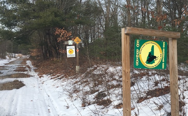
Where the work of one snowmobile club ends, another’s begins.
While we’re on the subject of walking in January, let’s thank the snowmobile clubs that groom so many of the trails I enjoy. It’s not all snow grooming: when a club takes responsibility for a trail, the members also do things like clear away fallen trees and make sure the trail’s full width gets attention.
I haven’t neglected my town’s conservation areas. I spent a brisk hour on a big loop route starting in Grater Woods, connecting with an adjacent neighborhood with which I was unfamiliar, returning on busy Baboosic Lake Road. I’m not a fan of being a pedestrian on one of our town roads with little shoulder and no sidewalk, but sometimes that’s where a path takes me. As for Horse Hill, I’ve never had a bad day there. No matter how many cars are in the parking lot, the trail network is extensive enough to keep us out of each other’s way.
Do you have resolutions about walks you want to take this year? I always start the year with a list of destinations, more for inspiration than anything else. I don’t want to waste time wondering where to go, if I find myself with a free afternoon. I just dip into The List, which I admit is heavy on rail trails. I also keep a map of New Hampshire on my wall, with outlines of each town, and after I walk in a new town I color in its spot on the map. I get a silly amount of satisfaction out of that little visual record.
Picking up litter is such a little thing, and I’ve really appreciated that act this year in pandemic time. Increased trail usage in my area has meant more trash on the trails, as people unused to using public lands haven’t yet developed good habits.
Does that sound patronizing? It’s kinder than my gut reaction, which is that people sometimes behave like jerks. Not a neighborly thing for me to think.
At any rate, I see folks rising to the challenge and picking up the trash. Some do so individually. (I keep a trash bag in my pack when I’m out and about, so I have one less excuse for passing by a dropped can.) Some people form or join crews, with the single purpose of cleaning up after thoughtless hikers.
Image by Mabel Amber from Pixabay
I have always admired people who are useful on trail crews. Someone has to cut the trails, build the bridges and boardwalks, and replace the bridges and boardwalks after they wear out. Someone has to clear deadfall every year. There’s always work to do. I’ve helped out in minor ways on such projects.
As far as I’m concerned, the people clearing trash on the trails this year are in the same league.
I learned from social media about a group close to home, whose members had dubbed themselves “The Litter Crew.” A few times a month, they announce a trail location and a date and time, and welcome anyone to come. They provide bags, buckets, gloves, and “pickers,” handy claws-on-a-stick.
A few days ago, the Litter Crew called for a cleanup in my town on a trail that I mistakenly thought had been abandoned a long time ago. Not abandoned, as it turns out: it’s a bit of a party spot as well as being a well-defined path through the woods. I collected a single bag’s worth of trash, but that made me an underachiever in this crowd. The total yield, as reported later on the Crew’s Facebook page: “21 Full trash bags, 3 tires, 2 back seats from a car, a bike tire, tons of beer cans, and we found multiple old TVs and a refrigerator.”
That’s one trail on one day in one town. You get the idea. Sometimes, teamwork is the way to go.
I’m grateful to everyone helping to keep New Hampshire trails tidy in this stressful time. It’s not just an aesthetic or environmental thing. It’s a kind and thoughtful act in a time when kindness and thoughtfulness can be hard to come by. Not a bad return on the small investment of picking up some trash.
Summertime’s blue asters abound along the Cohos Trail.
Fifth in a series of posts journaling my 2009 hike on the northernmost section of the Cohos Trail.
(Update, 2026: the completed Round Pond trail was laid out on a route different from the one we flagged, which gave me a lesson in trail development: landowners can change their minds. See cohostrail.org for current information on the trail. Deer Mountain State Park is still there, an unpolished gem that should stay unpolished. Moose Alley Cones has a new location, closer to Back Lake.)
The trouble with full days is that I get tired in the evenings when it’s time to record the day’s events. Not a bad problem to have. Today was tiring, but quite satisfactory. My aching body is aching less, which is encouraging.
Today, I worked on a new segment of the Cohos Trail, which we all hope can soon be formally dedicated. I was with Lainie Castine, practically a legend among Cohos Trail builders. We started at Round Pond, where the proposed Round Pond Brook trail begins winding its way to US Rt. 3. As of now, the CT is on US 3 from River Rd. in Pittsburg to the Quebec border. Alternate routes & spurs are slowly being designed & approved, and will be developed piecemeal. The RPB trail was flagged by CT volunteers last spring, and state approval is pending, with a walk-through by a state official needed eventually.
Lainie handed me a pair of loppers & told me to follow her & look for flagging tape. Within 10 minutes, she realized that someone had come through & reflagged the trail on a slightly deviated route. Her GPS was only slightly helpful, but our compasses sure came in handy. I did very little lopping, but I helped get the trail’s flags back where they belonged.
A problem that became obvious — far more obvious on the Camp Otter Trail, where we worked in the afternoon – is that the flagging earlier in the year was done in the spring, before summer grasses grew several feet high. Some trail routes along snowmobile trails looked just lovely 4 months ago. Now, it’s midsummer. Grasses & ferns & the aptly-named hobblebush have grown several feet high. The snowmobile clubs won’t be working on the trails again until fall. The routes we checked today would pose a maintenance nightmare. Not an insoluble problem, to be sure, but a challenge.
We were on game trails when we weren’t on snowmobile trails. I saw a bobcat track for the first time. We saw plenty of moose tracks, as well as a spot in the Camp Otter area that’s obviously used by moose as a place to bed down. Bears left the most traces, though: prints, scat, more scat.
Coming out of the woods on the Round Pond Brook trail, before we got to US 3, we came upon a field full of Joe-Pye Weed and bee balm. This area is bursting with summer blossoms.
Camp Otter was an arduous couple of miles of slogging through mud & stumbling over long, tangled vegetation. This is the area where the trail association wants to put in 500′ of badly-needed bog bridging. I’m told that the materials have been acquired but are being stored down in Stark.
Rain began as we started to whack our way through the vegetation along Camp Otter trail. We were already so muddy that we didn’t care. Lainie is fine company, and she is undeterred by such minor matters as mud! Her attitude was contagious. She fed waypoints into her GPS, reflecting the improved trail route we flagged today. I became the first non-CT-board member to hike these segments. With breaks, it took us about 5 hours to walk/bushwhack/slog 4.1 miles. We felt like very wet pioneers when we were done.
We really were filthy by the time we were shuttled back to the Bungalow. Lainie insisted that I get first crack at the shower, and she was kind enough to put my muddy clothes along with hers right into her washing machine. Once I was cleaned up, I made a double batch of mac & cheese for a late lunch, and that simple little dish was perfect.
As I ate, I thought about some of the things I had planned to do on this trip. After only a couple of days with blisters, I had to admit to myself that Mt. Magalloway is out. I lost it the moment I dunked my feet in the mud on the Lake Francis trail and then didn’t dry them promptly. A steep uphill walk would be torture at this point, leaving me unfit for the other walking I need to do. There are already unexpected delights on this trip, though, in areas to which I could never have dayhiked from here.
Later, with my laundry hanging to dry, my hosts proposed a ride — “bring your camera!” We piled into their beat-up but valiant truck, and off we went.
First stop, Young’s, where everyone had things to pick up. Second stop: Moose Alley Cones, where I reveled quite messily in a double scoop of chocolate moose-tracks ice cream. Good thing I’d bought paper towels at Young’s. This ice cream stand had been on my to-do list for the trip, and I hadn’t told anyone about it, so this was an auspicious start to the road trip.
We proceeded north on US 3, the “Moose Alley” of all the tourist literature. We stopped at Second Connecticut Lake, at the boat ramp off the highway. We were the only people there. Once out of the car, I looked around in awe, overcome by profound silence. We were away from the dam at the lake’s south end, so there was no sound of rushing water. At that moment, there was no bird’s song or call, though I’m told loons are frequently seen here. No aircraft overhead, no carloads of tourists, no boats or boat motors – a place & a moment of peace, with nothing in view but the lake & the spruce trees all around.
From there, we drove north a couple of miles to Deer Mountain State Park, a campground with 20-some-odd sites. This gave me a chance to scout my quarters for next Sunday & Monday nights. Pleasant spot, lots of trees, Connecticut River the size of a brook rushing down a stretch called Moose Flowage: all good. The attendant lives on-site; we’re way beyond commuter territory. There’s no rec building or any other community structure. About a third of the sites were occupied, which confirmed my hope that a reservation & its fee would be unnecessary. I love the signs I’ve seen at all three state parks on this trip: “If office is closed, occupy any available site” – and leave the fee at the iron ranger, of course. Lots of honor-system operations up this way. As I expected, there’s no electricity at the park. In fact, we’d left the last US utility lines behind us a few miles back. The park also has no water supply aside from a single spring, piped up at a spot near the entrance.
Notes made & photos taken, I hopped back in the truck. We headed back south past Second Lake & turned east onto Magalloway Road. I noticed mile markers, and it turned out that all the back roads we were on last night had them. I suppose they’re useful, as long as you don’t expect to use a cell phone to summon help to your broken-down car at mile marker 3 on Magalloway Road. There is no cell signal there. (Update, 2026: cell service has come to portions of Pittsburg.)
These back roads, originally created by logging companies & still maintained in part by them, cut right through thick, thick woods. Spruce predominates. “Great North Woods” is no mere chamber of commerce conceit. We passed a number of small logging cuts that hardly put a dent in anything. The spruce all looked nearly black as the sun began to set.
At a fork we headed right, to Buckhorn Road. There were camps here & there, most of them looking neat & maintained despite the absence of cars in the driveways. The sky to our right was beginning to take on beautiful tints & tones in the last of the day’s light.
Another turn put us on Cedar Stream Road – the same Cedar Stream Road I’d found so boring a few days ago. We were miles farther east, though, at mile marker 19. This stretch was wilder, with fewer camps, and still no moose. We drove westward, & the full glory of the sunset was right in front of us. I could afford to enjoy it; I wasn’t the one who had to drive into the glare.
At the intersection where I had veered off to the Bog Branch bridge & the Lake Francis trail a few days ago, we turned left onto the east end of the nine-mile-long Deadwater Loop Road. This was the Wild America stretch, seen by very few flatlanders like me. This would have made a more interesting hike than Cedar Stream Road, coming from Rudy’s. I’ll remember that the next time I’m up this way.
Approaching the village, we turned onto Cedar Stream Road again, then Rt. 145 and then US 3. We drove onto giant Murphy Dam – giant for these parts, anyway. Pete told me this is an earthen dam, built in the 1930s.
Back on US 3, we passed the Pittsburg high school. I’m going to get a picture of the building on Old Home Day next weekend so I can show my son the home of the class S baseball champs. Their tournament victory made the front page of my downstate newspaper a few weeks back — a high school of 37 kids, with 14 of them on the team.
(As I write this, a small plane is passing overhead. That’s unusual here.)
The evening ride’s last leg was around Back Lake, ringed with inns and resorts. As we returned to Danforth Road after three unforgettable but mooseless hours, I said it would be funny if we drove over 40 miles & didn’t see a moose until 200 yards before the driveway. I was off by just a bit. On the way up Danforth, there was our one & only moose, waiting for us as if hired. Our tour was complete.