Long ago when I began exploring Granite State trails, I had a little point-and-shoot film camera that I carried everywhere. I have a shoebox full of prints from those early outings: evidence of an utter beginner. I didn’t know how to frame a shot. I didn’t know that it was hopeless with the fixed lens I had to get a focused close-up of a trillium in bloom. I had trouble holding the camera steady.
Even so, a few of those old prints remain special. They documented my first views of places that I later came to love. Some of those first impressions were dramatic, others much less so. I had no way of knowing that the gifts of time and memory would draw me back to certain places over and over again, seeing and learning new things with each visit.
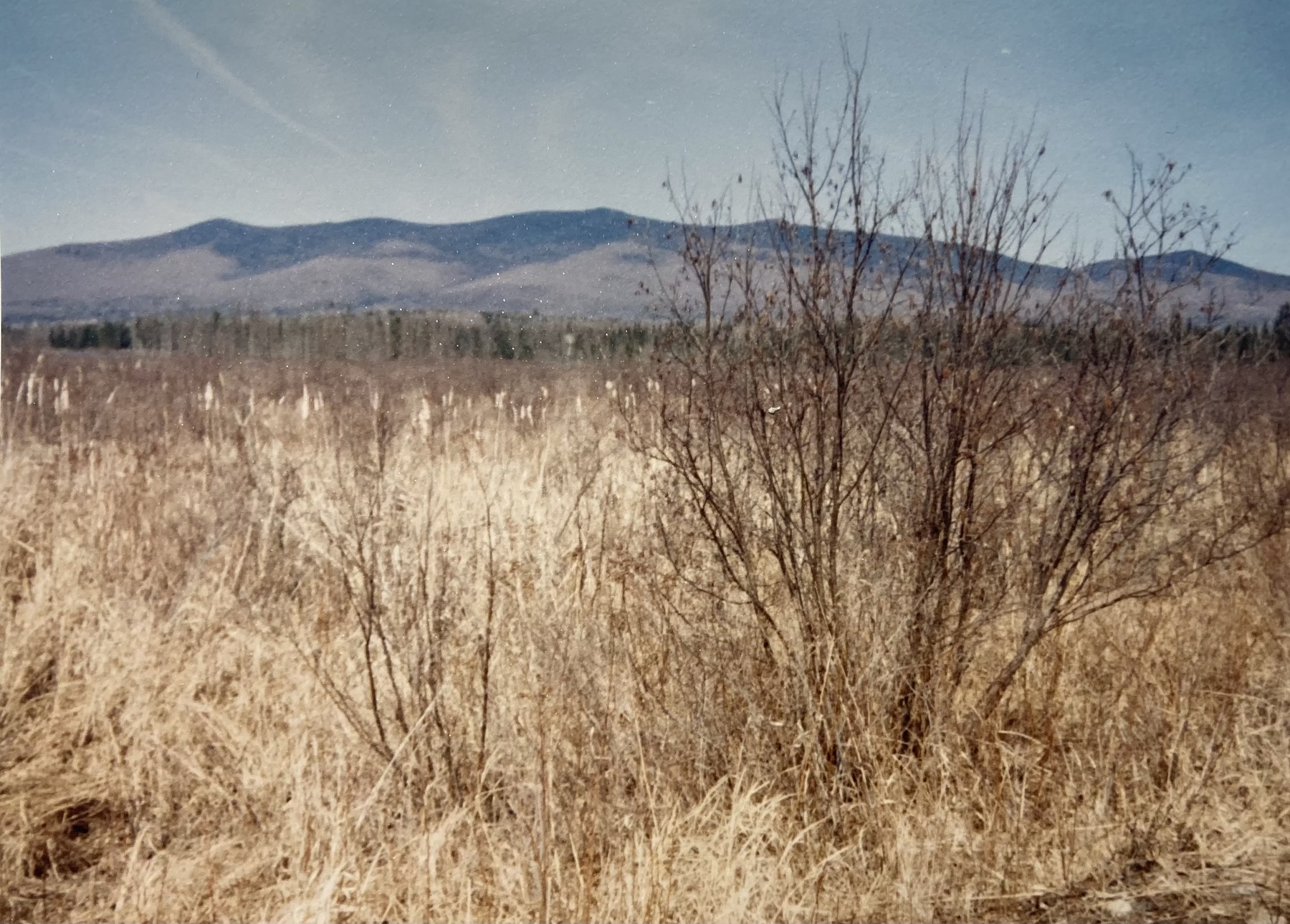
My very first sight of the Pliny Range from the marsh near Cherry Pond was on an April day as I made my first visit to the Presidential Rail Trail. Spring was playing hard to get. I took a photo that captured trees not yet in bud and grasses clad in the dullest of colors. Something about those hills in the distance appealed to me, though, and I wanted to capture them, too. So I snapped the shutter, heedless of the tree in the way.
First impression: Pliny Range seen from Pondicherry Wildlife Refuge, Jefferson NH
Those hills enchanted me in a way I can’t explain. They invited me back as though they knew I had more to see.
That day of that first impression, I had no notion of the riot of flowers that would line that trail and surround Cherry Pond in summer. I didn’t know how autumn would transform the Pliny Range. I had yet to discover how I’d feel sitting in silence by the pond on a freezing January day with the hills hidden in low clouds. All of that lay ahead. It started for me with a dull spring day preserved in an unremarkable snapshot.
Think about a place you’ve hiked, a place that’s grown on you, maybe even snuck up on you to become a favorite. What was your first impression? Did you know when you first saw it that it would become someplace special for you? I hope you take a photo of each new trail, and don’t succumb to the siren song of the “delete” button. Some of those shots, awful though they may be, will make you smile someday. First impressions aren’t final, but they’re worth remembering.
My autumn began with a trip upstate as the leaves began turning. As October ends, I’m near the Massachusetts border, where red and orange foliage has yielded to gold and bronze. The sunlight through the leaves these days creates a glowing aura around everything.
First stop: North Country
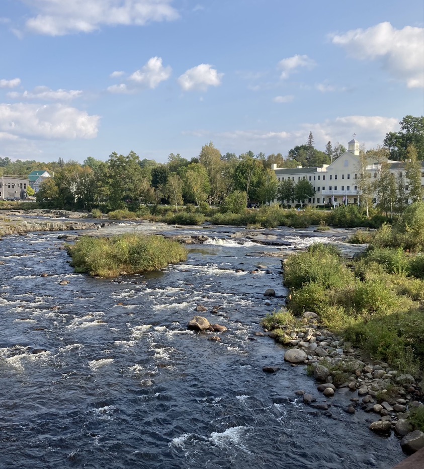
Three days on the Ammonoosuc and Presidential trails in early fall added up to 30 miles of walking for me, punctuated with unexpected meetings. Amazing, the encounters I’ve had walking through New Hampshire.
The Ammonoosuc trail follows – you guessed it – the Ammonoosuc River. While checking out the three newest miles of the trail east of Littleton, I met a couple I know from the NH Rail Trail Coalition. We were pleased to see that the new section, between Cottage Street and Oxbow Drive, has a great surface that will be especially helpful to anyone biking the Cross New Hampshire Adventure Trail. The following day, I met up with yet another NHRTC colleague while on a gravelly Ammonoosuc stretch between Lisbon and Bath. That surface is in the process of being upgraded from gravel to a smoother crushed stone. Can’t happen soon enough, as far as I’m concerned. My feet took a bit of a beating that day. I gave them a rest as I ate my lunch under the picturesque Bath covered bridge.
Ammonoosuc River in Littleton NH. All photos by Ellen Kolb/Granite State Walker.Bath NH: lunch spot along the Ammonoosuc River, under the covered bridge.
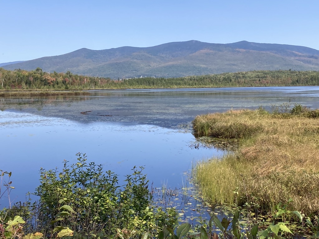
I was in the Pondicherry Wildlife Refuge a few months ago, when Joe-Pye weed and Queen Anne’s lace were blooming all along the Presidential rail trail. When I returned in early fall, nearly all the blossoms were gone, except for a couple of hardy little asters holding out against the equinox. Milkweed pods had burst and left their seeds floating across Moorhen Marsh. Frost had nipped the north country and its mosquitoes, making the walk to Cherry Pond even more pleasant than usual. My last view of the pond had been when it was covered with water lilies. This time, the pond was a mirror for Mt. Starr King and the Pliny Range.
If I were to search this blog’s sixteen years of posts, I’d probably find a dozen photos of the views from the Cherry Pond observation deck. Even when I know I’m standing in the same place and pointing the camera in the same direction as I did on an earlier walk, I’ll get a unique image: different light, different season, different shades of earth and sky.
Cherry Pond in the Pondicherry Wildlife Refuge, on the Presidential Rail Trail, Jefferson NH.
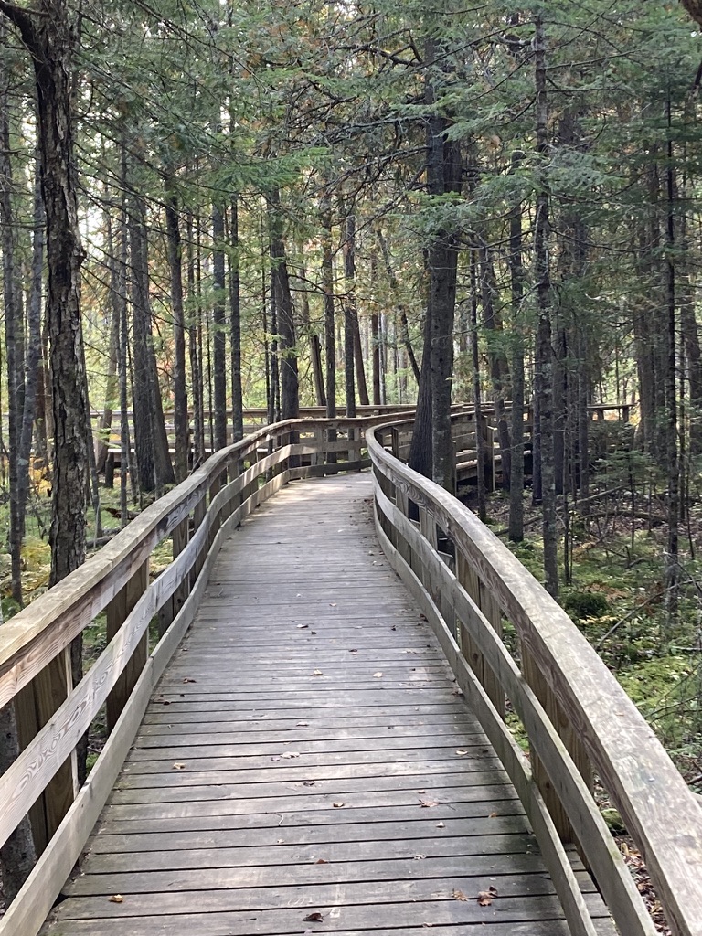
I decided to re-visit Mud Pond trail, also in the wildlife refuge but north of Cherry Pond, with its trailhead off of NH Route 116. I was there some years ago when it was brand-new and awaiting finishing touches. Now, it’s a small gem. Bonus: it’s designed to be accessible to anyone in a wheelchair, with switchbacks and boardwalks and easy grades along its half-mile length. It ends at Mud Pond, which really deserves a better name. It’s pretty and peaceful, and the observation deck must be a birdwatcher’s dream.
The trail to Mud Pond in Jefferson is designed for maximum accessibility, leading to a good spot for birdwatching.
Walking for a cause
Mid-October, I walked 13 miles on the Rockingham Recreation Trail in Auburn, Candia, and Raymond with a group raising funds for a shelter in Manchester. We couldn’t have picked a better October day. From a foggy sunrise over Lake Massabesic all the way to full midday sunshine in Raymond, I enjoyed good company.
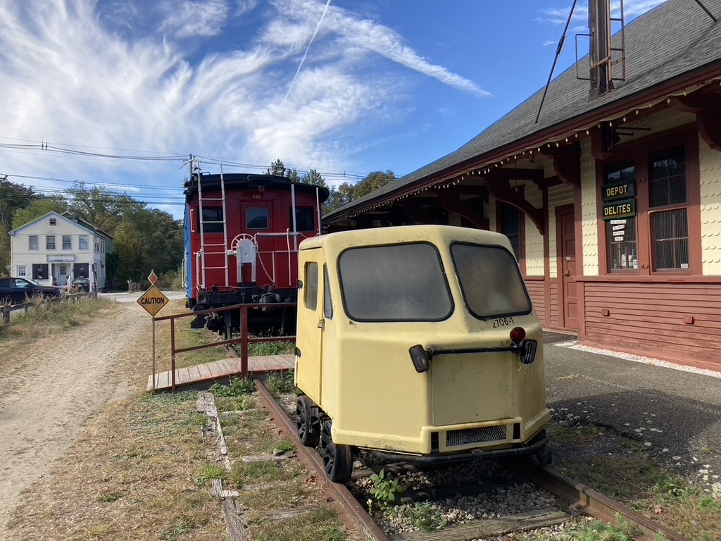
I hadn’t passed by the old Raymond Depot in awhile, and it was fun to see it again. The littlest rail car – I call it a putt-putt, though it probably has a more dignified name – always looks a little lost on the siding, dwarfed by the more conventional rail cars nearby. They’re all part of the old rail line’s history, so they all belong there.
Raymond Depot along Rockingham Recreational TrailA golden October day on the Rockingham trail
One piece at a time
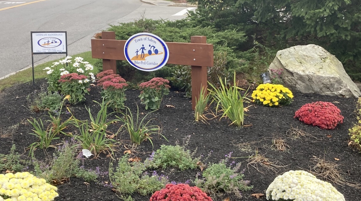
Just a few days ago, I attended a ribbon-cutting for a trail in Salem, New Hampshire. A trail segment, to be more precise. A 300-foot segment, if you must know.
Okay, let the eye-rolls commence. But I drove the better part of an hour to be there, because getting that segment finished took years, and I wanted to thank the people who had made it happen. This is the Salem (NH) Bike-Ped Corridor at the Massachusetts state line. Its significance: it’s the south end of what will someday be the Granite State Rail Trail extending from Salem all the way to Lebanon, just this side of Vermont.
A piece of the Salem trail is already in use further north of the newly-christened segment, extending into Windham and Derry. This is the same old rail line that includes what’s now the Londonderry rail trail, which will someday connect with the South Manchester trail, which will someday connect with yet-to-be-built trails in Hooksett and Bow and Concord, finally connecting with the Northern Rail Trail that’s already complete from Boscawen to Lebanon.
This is how long trails are built, whether they’re remote or urban, flat or mountainous: one piece at a time, even if some of those pieces are only be 300 feet long. Over time, those pieces add up.
Pocket park on the Salem Bike-Ped CorridorDignitaries and trail advocates celebrate a newly-completed segment on the Salem Bike-Ped Corridor.
I seldom get to Salem, so I spent time after the ribbon-cutting ceremony walking south along the Bike-Ped corridor into Methuen, Massachusetts. It was easy to ignore the traffic noise from nearby heavily-developed Route 28. Instead, I concentrated on the sights, sounds, and fresh clean smells of the wetlands and pocket parks along the way.
“Past peak,” say the foliage reports. Don’t you believe it.
My husband and I drove to northern New Hampshire for a hastily-planned weekend trip for some hiking and biking, past the peak autumn foliage and the oppressive crowds driving to see it. The cloudy weather got cloudier. Traffic got lighter. When we stopped at a little inn on U.S. 2, we were exactly where we wanted to be.
You can call it “past peak.” I call it just fine.
It was not a weekend for grand vistas or clear night skies. Low clouds were the rule. My favorite lookout spot on the Weeks State Park Auto Road, which usually features a showstopping view of the Presidential Range, featured nothing but a wall of fog.
So instead of looking at things miles away, I spent more time looking at things like the carpet of red maple leaves under my feet. I liked walking for miles in the cool conditions. Segments of the Presidential Rail Trail were ideal.
The only noisy mile of trail was one I shared with ATVs in Gorham when I wanted to get a look at the Androscoggin River from a trail bridge. Once I’d done that, I scooted back west to where the trail was closed to motorized traffic. Once I was on that stretch, I saw a grand total of three other people in five miles of walking.
Androscoggin River, Gorham NH: low in October after a dry summer. Ellen Kolb photo.
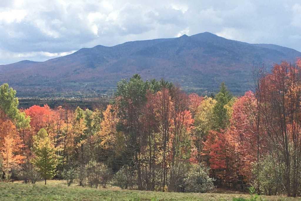
At one point during the weekend, the clouds lifted enough to reveal nearby Cherry Mountain, which for once wasn’t just a visual foil to all the other peaks in the area. I was lucky enough to be walking on the Presidential Trail in the Pondicherry area (trailheads on Airport Road in Whitefield and NH Route 115-A in Jefferson) when the sun came out and the view opened up.
It’s time to dig out my blaze orange gear. My favorite hiking season is at hand. I have no complaints about the season just ended, though. It was a beautiful summer in New Hampshire and beyond.
Mt. Kearsarge, Rollins State Park, Warner
The fire tower on Kearsarge was getting a serious makeover this summer, with heavy mats laid over the trail from Rollins State Park to accommodate construction vehicles. Hikers were still welcome, though. The broad ledgy summit offered its usual fine views.
view from Mt. Kearsarge summit, Warner NH. Photos by Ellen Kolb.
Mt. Kearsarge fire tower gets a makeover, summer 2019
While I was there in July, a group of kids from a Boys and Girls Club arrived on the summit with their chaperones, having hiked up from the state park on the other side of the mountain. One boy, maybe ten years old, bounded around like a puppy. “Dude! I’ve never been to the top of a mountain before!” I suspect he’ll go in search of more.
North Country trip
Four days of car camping in August brought me to trails in Pittsburg and Jefferson and a few places in between. Ramblewood Campground in Pittsburg and Percy Lodge and Campground in Stark served as homes-away-from-home.
It’s tough to pick my favorite part of the Cohos Trail. On this trip, though, Pondicherry Wildlife Refuge in Jefferson staked a pretty strong claim. I circled the refuge one sunny afternoon, stringing together several trail and road segments to make an 8-mile loop. Once out of the woods, the view was all about the surrounding peaks: Mt. Martha to my south, the Presidentials to the east, and the Pliny Range to the north. That just might be the most rewarding flat hiking route I’ve found so far in New Hampshire.
Cherry Pond, Jefferson NH. looking toward Pliny Range.
I didn’t limit this trip to Cohos Trail segments. I discovered Second College Grant, a Dartmouth College property the size of a town, where I enjoyed a serene walk alongside the Dead Diamond River. Another day, perhaps I’ll return for a hike up Diamond Ridge.
From Stark, I took a quick drive to Milan Hill State Park to check out late-afternoon views from the fire tower. Not a hike, but still a treat.
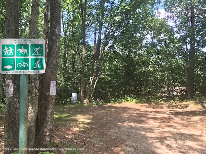
New Boston rail trail
What a difference since my last visit about five years ago. I found the shady New Boston rail trail south of Lang Station upgraded significantly since my last visit. Trail volunteers, take a bow.
New Boston rail trail, NH
I walked for the first time north of Lang Station on the trail to the Goffstown line. Very different up that way: a work in progress, or maybe just in the planning stage. I found blowdowns, mud, and at the Goffstown line, an overgrown swath separating the trail from Route 114.
Someday, if a whole lot of things work out just right, the New Boston trail will connect with the Goffstown rail trail, which already connects to the Piscataquog trail in Manchester.
Zion, Bryce Canyon, Grand Canyon: life-list material
My husband and I spent nine too-short days in Utah and Arizona in early September, where I got my first-and-maybe-last look at some of the gems of the national park system:
Zion, where temps in the low hundreds did nothing to dull the scenery…
Zion National Park, Utah
Bryce Canyon, land of the hoodoos, where even a half-moon can’t blot out the stars at night…
Bryce Canyon National Park
and Grand Canyon’s North Rim, far from South Rim’s crowds, where the sheer scale of the canyon left me speechless.
View of Grand Canyon from North Rim, Arizona
Along the way – it takes a lot of driving to see all three parks in only a few days – we found some beautiful lesser-known recreational areas: Cedar Breaks and Red Canyon in Utah, and portions of Dixie National Forest in Arizona.
As our return flight descended over the Monadnocks on the way into Manchester, I was happy to see our familiar green hills. This is home. Still, I treasure the awesome sights and beautiful places we saw out west.
A friend and I have been trying for several weekends to arrange a hike, with last-minute work commitments sabotaging every trip so far. Still, we keep planning. When I suggested Pondicherry Wildlife Refuge, she said “where’s that?” I was going to refer her to a blog post here, when I discovered to my embarrassment that I hadn’t yet written about this lovely place, despite my fondness for it. Oops. Making up for lost time here.
The refuge straddles the towns of Jefferson and Whitefield. To get there from southern New Hampshire, I take I-93 through Franconia Notch and then U.S. 3 through Twin Mountain into Whitefield. There’s a airport sign in Whitefield pointing me to a right turn off route 3. A drive around the south side of the one-runway airport brings me to a little biomass plant, across from which is a well-marked parking area for Pondicherry.
Cherry Pond, with Presidential range at left and Mount Martha at right. All photos by Ellen Kolb.
Pondicherry trailhead, on Airport Road in Whitefield.
From the parking area, one could be forgiven for thinking “is that all there is?” The Presidential Rail Trail extends north from there, looking like a long dirt boulevard. (In fact, it’s a busy snowmobile thoroughfare in the winter.) Cherry Pond is a mile and a half away via the trail. During my April visits, little spring flowers are usually peeking up on the sunny side of the trail when there’s still ice along the shaded side. I seldom have company here, and there is little noise except for the occasional small plane landing at the airport.
The walk into the refuge is tree-lined, making the sudden view of the Presidentials all the more startling when I arrive at Cherry Pond. I never get tired of that view.
Nearby are Little Cherry Pond and the adjacent wetlands. The Cohos Trail passes through, piggybacking on the Presidential Rail Trail for some distance. There’s an observation platform, affording excellent views for the birdwatcher who remembered to bring her binoculars. Critters of all sizes, from beaver to moose, find Pondicherry a congenial place.
An active (but not busy) rail line runs through the property as well. I sometimes see a few freight cars parked on a nearby siding. This quiet location still bears the old rail-line name Waumbek Junction.
Pliny Range, north of Cherry Pond
The Pondicherry refuge is a cooperative venture of state, federal, and private organizations. A good guide to the Pondicherry trails can be found in the Jefferson Dome chapter of Kim Nilsen’s book 50 Hikes North of the White Mountains.
Update, 2026: Since I wrote this entry, Pondicherry Wildlife Refuge has found its way into many of my posts. I describe a recent visit in “One way to celebrate, part II,” with summertime photos.