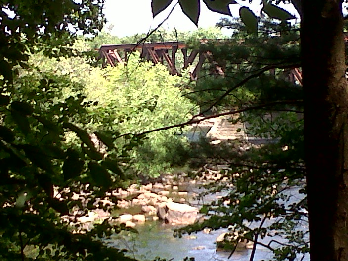
View of Merrimack River from the Bedford Heritage Trail
The Heritage Trail in Bedford, New Hampshire doesn’t demand a lot of time from the casual visitor, although you could go on a slow mile-long birdwatching walk if you were so inclined. I decided to head there for a quick lunch-hour visit.
I found the trailhead on Moore’s Crossing Road off of US 3 (South River Road). From the parking area, I walked north and quickly found a picnic area overlooking the Merrimack River and the Moore’s Crossing railroad bridge.
Eagles have nested along the river, though I didn’t spot one this day. The herons made up for that. The rail bridge is somehow not ugly from this vantage point, despite the graffiti on it. Perhaps all the trees around me softened the view. The river is low today, reflecting the recent lack of rain.
I work near the trail, and today’s picnic beat having lunch at my desk. Employment is great, but my current job is making long hikes impossible for now. I’ll get out to good spots like this when I can, even for twenty minutes at a time.
Silver maples bend over the trail at the Forest Society’s Merrimack River Education and Conservation Area, Concord NH. Ellen Kolb photo.
The Society for the Protection of New Hampshire Forests headquarters is in Concord, off of I-93’s exit 16. Follow signs for “conservation center”, and you’ll find the headquarters on Portsmouth Street.
The Forest Society trail network at this property runs along the Merrimack River and includes a pine plantation, a silver maple forest, floodplain, and a river cove with a canoe landing. The traffic sounds from nearby I-93 are easy to ignore. In this drought, the river is quiet, but the sharply-cut banks indicate how high the Merrimack can run in a rainy season.
I stayed here longer today than I had intended, stretching a quick lunchtime walk into an hour. The trail is flat & sandy; no boots required. The bugs are out, so bring your insect repellent. This is an undramatic, peaceful spot for a walk, and it’s open from dawn to dusk.
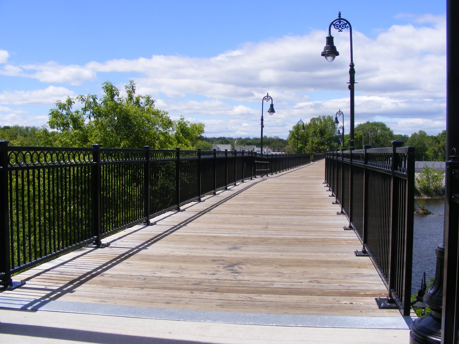
It took a whole lot of people, headed by Manchester resident Helen Closson, to make a pedestrian bridge out of the abandoned rail bridge across the Merrimack River in Manchester, New Hampshire. Closson called the project “Hands Across the Merrimack” while it was underway, and whatever name the pedestrian bridge may be given officially, that’s the name I’ll remember.
I’ve been on the bridge before, just for the fun of crossing over the Merrimack on foot. Today, after some business in town, I took advantage of the sunny afternoon to walk the rail trail clear across Manchester’s West Side. This is Manchester we’re talking about, so “clear across” means about two miles.
Starting from the baseball stadium where the Fisher Cats play on the river’s east side, a paved walkway runs parallel to the Merrimack and shortly comes to a fork. Going right would have brought me under the rail trail and onto some private property. Going left brought me around a sweeping curve to the approach of the Hands Across the Merrimack bridge.
I was a bit startled to find a sculpture of a steer just short of the bridge. The plaque mounted nearby noted that the statue was a tribute to workers & entrepreneurs like the ones from the former JacPac meat processing plant located nearby, now the site of a hospital expansion.
Vandalism has become an issue along the trail, judging from some news reports I’ve read. It looked good today, though. I’m sure that’s an ongoing effort by people who care. The trail is paved its entire length, and the pavement’s in good shape.
The bridge is at the southeast end of a trail that parallels the Piscataquog River. For now, the northwest end of the trail is near what I call the Kelley Street bridge (Nazaire Biron Bridge on my map) that links the West Side with the Pinardville neighborhood. There’s a very hazardous crosswalk on Main Street, but the few other road crossings are in quiet neighborhoods. The trail, like the rail line before it, goes on a bridge over Second Street, avoiding a road that’s just as busy as Main Street.
The Piscataquog River snuck up on me. I cleared Main Street & followed the trail behind a house where there was a cheerfully noisy party going on. As the music from the party faded behind me, I became conscious of the river’s sound, and soon the river was in view. A few weeks ago, we had heavy rains, and this river was particularly pesky for the people living along it. Today, though, it was a tame & pretty thing. Several dirt trails ran steeply from the trail down to the river. I stayed on the pavement, worried that I’d twist an ankle trying to negotiate the slope in my sneakers.
Eventually, I came to some ball fields, where a softball game was just wrapping up. Soon I was in sight of the ugly red bulk of West Side Arena. The building’s homely appearance belies its worth as an athletic facility for what seems like every kid on the West Side. Soon I passed under the Kelley Street Bridge and reached what is now the end of the trail.
Once upon a time, this rail line crossed the Piscataquog near Kelley Street, and then paralleled the river (on its north side now) through Goffstown & into New Boston. Patches of the line have been developed into trails. I’ve been on one segment in New Boston near where the middle & south branches of the Piscataquog converge — a beautiful spot. In Goffstown, determined residents have turned part of the old railbed into a trail, and they continue to try to finish the link between New Boston & Manchester.
[Update, 2015: that link, a bridge over the Piscataquog River, was completed in 2015. Trail users can go from Manchester’s baseball stadium all the way to Goffstown center.]
For now, though, all I saw after crossing under Kelley Street was a fenced-off trestle hung with “Keep Off” signs. I suspect that tight municipal budgets and concerns about liability will keep that trestle from ever being turned into a pedestrian bridge. Of course, that’s what I used to think about the bridge across the Merrimack. [Update: five years after I wrote this, the Piscataquog River trestle was indeed rebuilt, thanks in part to the generosity of the Singer family.]
This is not a path I would take after dark. I have no problem visiting on a weekend afternoon in broad daylight.