A decade of good times

While the rest of the nation is occupied with the presidential election, I’m celebrating a modest milestone: I started this blog ten years ago this month.

IMG_20151026_112231

Second Street bridge, near east end of Piscataquog Rail Trail, Manchester NH. All photos by Ellen Kolb.


It’s still a fun project for me. It reaches only a handful of people, including a few very faithful readers to whom I send my grateful greetings. Granite State Walker is mainly my online journal and album, a repository for my memories and a resource for trips yet to come.

Most of the posts in this anniversary month will be looks back at some of my favorite destinations. Many of those destinations are close to New Hampshire’s largest cities, easily accessible, and good for kids as well as adults. Maybe one of them will become a favorite of yours.

DSCF0470

Woodmont Orchard near Silver Lake State Park, Hollis NH.

I love my southern New Hampshire trails more than ever. I appreciate trail maintainers more than I used to. I understand more than I did a decade ago about the long administrative slog that goes into authorizing a new recreational trail even before the first weed is whacked.

I’m grateful to many people I’ll never meet, whose work has left us with parks and trails to which I return again and again. The blogging shall continue as long as I have “wows” to express. No end in sight, at this point.


Glimpses of fall

It’s the prime part of the year for Granite State walkers of all ages. Crisp air and fewer bugs make every trail more inviting. And then there’s fall foliage, which I thought would be a disappointment after our region’s drought. How wrong I was.

I have a paper map of New Hampshire that I’ve marked with sites of historical markers, Forest Society reservations, and of course state parks. It’s a great guide for my daytrips. Last weekend, I consulted the map and set off to scout some trailheads for future exploration. I meandered all over the place, just for fun.

Once I got home, I discovered that many of the photos I’d taken with my phone were unfocused and useless. (I blame the equipment and the photographer in equal measure.) You simply have to trust me that it was a good day. You can make some good days of your own on Granite State highways and trails.

Effingham

The drive to the Green Mountain trailhead at the end of High Watch Road was the stuff of travelogues. There’s a point on Route 16 northbound from Rochester where I got to a rise in the road, and suddenly mountains were in view, swathed in colors. Past peak, perhaps, but still exciting and refreshing.

img__201610289__051550

View to the north from High Watch Road. I’m pretty sure that’s Mount Chocorua in the distance on the left. A hike for another day, perhaps?

Once on the trail, I very nearly threw away my watch. There was a fire tower up there, after all, and what views it promised! But this was a scouting trip, and I had a schedule to keep, so I contented myself with a short walk in the woods and a silent promise to come back someday.

New Durham

Route 11 connects Rochester and Alton, with New Durham along the way. A 55-mph speed limit makes scanning for trailheads a bit tricky. I plugged the coordinates for Cooper Cedar Woods into my phone’s GPS and hoped for the best. It worked, which is always a pleasant surprise to someone who surrounds herself with low-grade electronics.

incoopercedarwoods

In Cooper Cedar Woods, New Durham, NH.

The wooded tract features a simple loop trail less than a mile long, and I had it all to myself. I set off and was startled immediately: the fragrance in the air was amazing. No cologne in a bottle could compare. It was some indescribable combination of trees and their fallen leaves, unique to that particular location. I could hear Route 11’s auto traffic nearby, and yet it seemed to be a world away.

Rochester

at-champlin-forest-rochester

Champlin Forest, seen from Route 108 in Rochester, NH

Early in my road-trip day, I was one of the walkers bringing up the rear at the Foley Run in Rochester, a joyous 5k event in memory of photojournalist James Foley. Main Street’s trees were at their showiest, right on schedule for the visiting racers.

After a quick post-race snack of bagels and fruit and (OK, I’ll admit it) a pastry, I drove south of town to a quiet parking area tucked across the road from the town’s airport. Here was the Champlin Forest, another Forest Society property, with about two miles of trails meandering through it. A woods walk, pleasant though unremarkable, except there’s this:

As a community resource featuring woods, water, wildlife and high-quality farm soils, Champlin Forest has many significant and diverse conservation features. Half of the property consists of well-managed, productive woodlands, containing marketable timber along with a diversity of wildlife habitats, consisting of a field, varied woodland types, vernal pools and wetlands.

The property serves as the headwaters of and includes extensive frontage along Clark Brook and contributes to two nearby public water supplies. Remnants of a small-scale granite quarry dating to the mid-1800s, when stones were drilled and cut by hand, are evident as well.

Rockingham Trail/Lake Massabesic

Workday or not, an 80-degree spring day calls for some trail time. Decked out in business clothes and dress shoes, I spent midday on a tame but worthwhile path: the Rockingham Recreational Trail from its Lake Massabesic trailhead in Auburn.

Rockingham Recreational Trail (Portsmouth branch), Auburn NH, east of NH Rt. 121

Rockingham Recreational Trail (Portsmouth branch), Auburn NH, east of NH Rt. 121

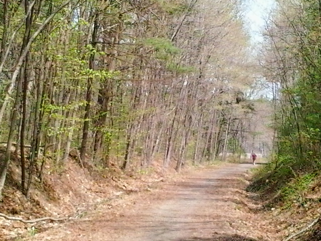
The trail extends more than twenty miles east to Newfields, which would make an interesting bike ride some other day. Pressed for time today, I walked only about a mile and a half before retracing my steps back to my car. I took my time to enjoy the birds (quite a variety near the lake) and take a few pictures from a boat launch. The trail is unpaved but wide and well-trodden. It was popular this midday: moms with kids, a guy fishing in a trailside pond, lots of dog walkers, even one dirt biker in defiance of the no-motorized-vehicle rule. (The operator’s trail manners were impeccable, aside from the motorized part.)

View of Lake Massabesic from boat launch just off Rockingham Rec Trail and NH Rt. 121.

View of Lake Massabesic from boat launch just off Rockingham Rec Trail and NH Rt. 121.

More information on this trail can be found on the New Hampshire State Parks web site and in the book New Hampshire Rail Trails by Charles Martin.

Groton, MA on Nashua River Rail Trail

I headed south of the border into Massachusetts on the Nashua River Rail Trail for a walk through the Groton stretch. Of the four towns along the trail, Groton is where the history of the rail line is most evident. The town is also home to the most park-like section of the trail, situated within the J. Harry Rich State Forest.

The harsh shadows in the photos are from the full midday sun, cheerfully blazing away on a summer day.

The trail crosses over Rt. 119 in Groton on a nicely rehabbed bridge.

The trail crosses over Rt. 119 in Groton on a nicely rehabbed bridge.

There are three trailheads in Groton, with the most parking available off of Broadmeadow Street. Smaller unpaved lots are at Sand Hill Road and Common Street.

Local students painted the walls of the trail's underpass at Rt. 225 with scenes of area history.

Local students painted the walls of the trail’s underpass at Rt. 225 with scenes of area history.

There are no “facilities” along the way, so to speak, but near the trailhead at Broadmeadow Road are a couple of benches and an informational kiosk. The posted information and illustrations are worth a look.

The best-maintained and most informative kiosk along the NRRT.

The best-maintained and most informative kiosk along the NRRT.

Groton is one of those genteel places with strict zoning laws that keep commercial signs tiny. How am I supposed to find the nearest place to buy a large iced beverage? That kiosk near Broadmeadow has a bonus: a map of Main Street and the roads connecting it to the trail, with nearby businesses listed. That large iced beverage is only a short walk away.

Marker on Main Street in Groton, a short distance from the trail.

Marker on Main Street in Groton, a short distance from the trail.

Some of the old rail line’s granite mile markers are still in place, and they’re kept painted by area volunteers. “P” is for Portland, Maine, and “W” is for Worcester, Massachusetts – once upon a time, the two ends of a line of the Boston and Maine Railroad. Of the 120 or so miles of that old line, twelve miles now make up the Nashua River Rail Trail.

"P" is for Portland, Maine, 114 miles from Groton by way of the old Boston & Maine rail line.

“P” is for Portland, Maine, 114 miles from Groton by way of the old Boston & Maine rail line.

Crowning the day was an abundance of Queen Anne’s Lace all along the trail.

Queen Anne's Lace is at full strength in July.

Queen Anne’s Lace is at full strength in July.


Hollis: Buffalo, Tough Cookie & Beaver Brook

Dan Szczesny, readying his slide show

Dan Szczesny, readying his slide show

Buffalo and Tough Cookie cover

cover of B&TC’s book

I got to shake hands today with a pair of hikers I’ve been wanting to meet. Dan Szczesny and his hiking partner Janelle are better known in the blogosphere as Buffalo and Tough Cookie. They were at the Hollis, New Hampshire library today with a slide show about their book, The Adventures of Buffalo and Tough Cookierecounting their year-long quest of New Hampshire’s “52 with a View.”

And just what might 52-with-a-view mean? I had never heard of such a list before discovering Dan’s blog. The only New Hampshire hiking list I had heard of was the 48 4000-footers. 52-with-a-view is a creation of the Over The Hill Hikers of Sandwich, New Hampshire who compiled a list of fifty-two peaks under 4000′, each featuring good views.

The audience in Hollis today consisted of an energetic group of kids who knew more about basketball than hiking. Dan didn’t worry about getting through the whole slide show as planned, cheerfully adapting his presentation to the everyone’s questions and comments. If he and Tough Cookie come through your area for a book signing or slide show, make a point of stopping by. You’ll enjoy the conversation and the wonderful photography.

I was very pleased when Dan told me their next hiking project and book are in the planning stages now: a trip on the Cohos Trail. Followers of this blog know how much I love the northern part of that trail.

Following the slide show, I took a short drive to the trailhead on Rt. 130 for Beaver Brook and spent an hour in the woods. It was a day for YakTrax on my boots, with thin snow cover melted-and-refrozen in many spots. I saw one couple on cross-country skis having a rough time of it. The temperature in the upper thirties felt positively balmy after the bitterly-cold month just ended (although bear in mind I’m a bit of a weather wimp).

There’s logging going on in Beaver Brook this winter, although no equipment was in use today. I appreciated the quiet. There are orange arrows spray-painted into the snow as traffic-control marks for the trucks, and signs affixed to some trees with an explanation to passersby of how forest management – which includes careful logging – has been part of Beaver Brook Association ever since it was established.

Showing those loggers where to go

Showing those loggers where to go


looking north from Bouchard Bridge on Beaver Brook

looking north from Bouchard Bridge on Beaver Brook

A New Year’s Day visit to Mt. Monadnock

I usually travel to Temple every New Year’s Day for the Peanut Butter Chip Chase 5k.  The drive from my home to the Wapack Range is beautiful, and I enjoy walking (not running) on Temple’s quiet roads. Today, though, I decided to bring in 2014 by heading to Mt. Monadnock for a First Day Hike sponsored by the good folks at Monadnock State Park. I chose a guided nature hike along the low and flat Parker Trail; the other option was an uphill hike to a spot with a good view. Each hike drew about twenty people, accompanied by guides from the park and from the Forest Society.

Yours truly celebrating New Year's Day on Mt. Monadnock
Yours truly celebrating New Year’s Day on Mt. Monadnock

I wore strap-on traction aids for my boots, and left my snowshoes in the car when I saw how icy the trails were. The temperature was about 15º, and I can tell you now what happens when you carry granola bars in your backpack on a 15º day: the bars freeze solid. (Three words for next time: inside coat pocket.) Lots of sunshine, though.

We were led by Meredith and Brenda of the park staff, along with a specialist in land conservation from the Forest Society. I didn’t take notes but soaked in what I could as they talked about forest management, wildlife habitat, and the history of the mountain. We walked at a very leisurely pace along the quiet Parker Trail. Half the fun was watching the kids in our group. A few of them appeared to be veterans of the trails. Others were wide-eyed and full of questions, walking a little unsteadily as they adjusted to having microspikes on their boots.

We were hardly the only visitors to the park, which surprised me. When I arrived at the headquarters entrance, the main parking lot was full and I had to proceed to the overflow lot. When I met Sue, the new park director, I asked her about that. “Oh, yes. We’re open year-round. Even on days like this, we get between 200 and 400 visitors.”

This is the third year that First Day Hikes have been held at New Hampshire state parks. I think I’ll be back next year.

A path to take another day: Lost Farm trail.