Some years back, the decline of New Hampshire’s North Country paper industry left up in the air the future use of over 100,000 acres in Coos County. Conservationists got busy in an effort to protect the land for recreation and forest management. A serious team effort resulted in the Connecticut Lakes Headwaters Working Forest in 2003. Time to celebrate the first decade!
Head to Lake Francis State Park in Pittsburg (get on U.S. 3 and just keep heading north) on October 5th for the big event. The Department of Resources and Economic Development – and has there ever been a worse acronym than DRED? – is hosting lunch and a few speakers at 11:30 a.m. At 1:30, the real fun begins. Attendees can choose from six tours, each in a different part of the CLHWF, lasting until 4:30. For more information, or to RSVP, email Eric Feldbaum at eric.feldbaum@dred.state.nh.us. With your RSVP, be sure to specify your choice of tours.
Want to hear about the Cohos Trail, and walk on a short segment? Yes, I know I write about the CT a lot. You can find out why if you join Lainie Castine after lunch on the 5th.
Maybe you like fire towers instead. If so, head to Mount Magalloway. Forty-five vigorous minutes on the trail will reward you with views that will knock your socks off.
Have you ever been to Boundary Pond? Here’s your chance to see it, if you’re ready for a drive; the boundary in question is with Canada. Other afternoon options include kayaking, a timber harvest forestry tour, and a local-history lesson. I wish I could head north for the event, although I’d have a hard time choosing just one afternoon activity. I encourage you to make the trip, if you are anywhere near northern New Hampshire. Again, let me mention that address for RSVPs, so the organizers know how many people to expect: eric.feldbaum@dred.state.nh.us
Yes, I love the Connecticut Lakes. My photography doesn’t do the place justice. I hope you can take your own photos there someday.
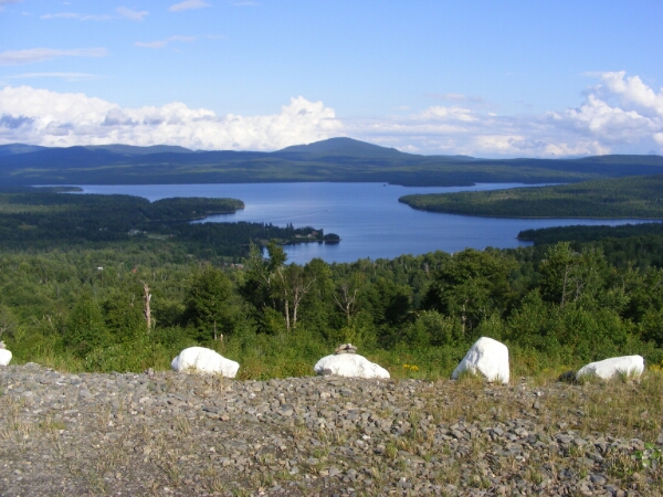
First Connecticut Lake and Mount Magalloway, from Prospect Mountain. Photo by Lainie Castine.
River Road covered bridge, on the way to Lake Francis SP. Ellen Kolb photo.
I spent this uncommonly warm April day driving upstate to Bethlehem, Littleton, and finally Lancaster. This is a blog about southern New Hampshire trails, but today’s trip was pleasant enough to rate a mention.
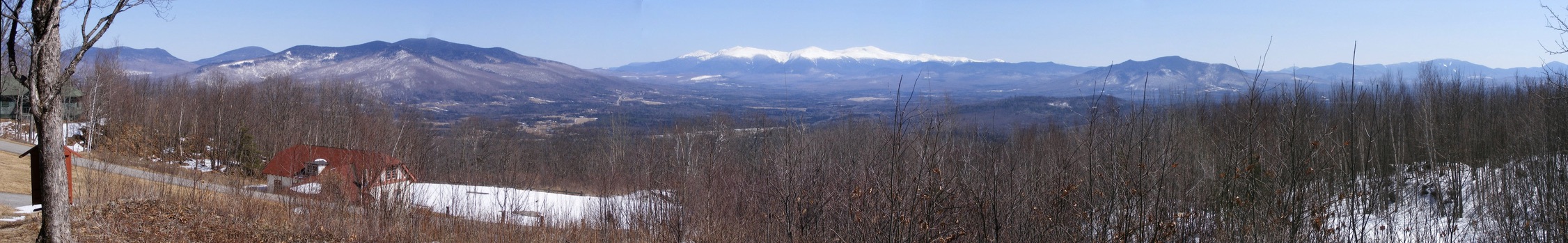
I found my way to the auto road up Mt. Prospect at Weeks State Park. The road is closed to auto traffic until sometime later this spring, but pedestrians may leave their cars at the base of the road and walk to the top. A pullout with a view of the Presidential Range makes walking even halfway up the road well worth the effort.
Looking east from the Weeks State Park auto road, Lancaster NH: the Presidential Range, snowcapped in April. Ellen Kolb photos.
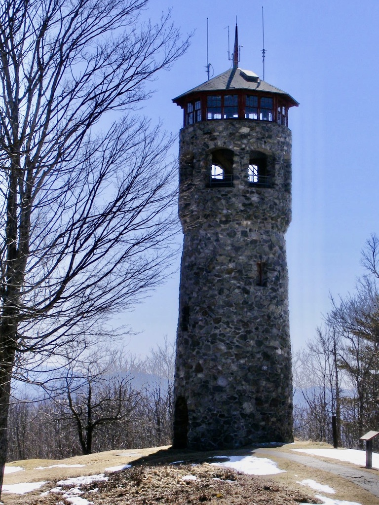
I didn’t walk all the way to Mt. Prospect’s summit on this trip, but I encourage readers to do so if they get a chance. The summit’s fire tower is unique. Instead of the usual metal skeleton, this one is a flagstone tower. This is an active firespotting station, and if you’re lucky, you’ll be there on a day when it’s staffed & the cab is open to the public. As you’d expect, the views are outstanding.
The entrance to Weeks State Park is on U.S. 3 in Lancaster, about 2 miles north of the Whitefield town line. Details are available at nhstateparks.org.
Fourth in series of posts journaling my 2009 hike on the northern section of the Cohos Trail.
(Update, 2026: Since this 2009 trip, the Mountain Bungalow no longer graces the Cohos Trail. See cohostrail.org for information on places to stay. On recent trips I’ve stayed at Ramblewood Campground in Pittsburg, which connects directly with the CT. Young’s Store is still going strong, but Happy Corner Café is long gone. I sure do miss their Corner Burgers.)
First Connecticut Lake and Mount Magalloway, Pittsburg NH
Sun came out 9-ish this morning, so I had a chance to spread out the tent fly and backpack to dry. In the hour before things clouded up again, I enjoyed a walk along the lake shore before I came back to pack up my gear. I blessed every one of those little plastic bags as I re-packed them into the backpack. Dry gear and a bit of sunshine did wonders for me.
I made a mental note of things to do differently if I’m ever possessed to to this again: get a lighter tent; bring fewer clothes for a midsummer hike; find useful rain gear; no more sleeping pads from Target. Pony up the big bucks for a light-but-cushy pad.
Today’s short hike brought me to the Mountain Bungalow, on the property of two Cohos Trail supporters, Lainie and Pete (update: ownership has changed hands and the Bungalow is no longer there). That’s going to be my home for a few days while I do some trail maintenance with Lainie and play tourist in Pittsburg. I’ve lived in New Hampshire for over 25 years, but northern Coos County is unfamiliar to me, and I want to see as much of it as I can while I’m here.
The walk up River Road to US Rt. 3, with a little shortcut marked with a CT sign, leads to what the map calls Happy Corner. What’s so happy about it? Check this out: Young’s store, a great little restaurant, and a covered bridge, all right there. (Oh, all right, I actually had to walk for 5 minutes to find the covered bridge. Don’t be picky.)
Young’s had the camp shoes I hoped for, lightweight & cheap. The Happy Corner Cafe next door served me a splendid lunch. Let me recommend the Corner Burger, piled with cheese, onions, mushrooms, & green peppers. Two tables over sat the family that camped at the site next to mine last night.
I headed up Danforth Road in a light drizzle, along the south slope of Prospect Mountain. (New Hampshire is littered with Prospect Mountains, I think, but this is the only one near Happy Corner.) It’s an uphill walk, but no killer. The bungalow was at the end of the road, a bit shy of the summit. Two moose, cow & calf, crossed the road ahead of me as I made my way up, but they were gone before I got my camera out. I was later told that I was lucky; moose are apparently an unusual sight on that road.
By the time I arrived at the Bungalow, the sun was out, and we had a gorgeous afternoon. My hosts gave me a friendly greeting and showed me around. I’m the only guest in the Bungalow. No running water, but there are plenty of jugs I can fill from the main house. There is electricity. There’s a radio, and I’ll check out the reception eventually. The kitchen is tiny but adequate. This all reflects a lot of work & care by my hosts.
A cache that I had mailed a week ago awaited me, providing a few days of food. Once I emptied the cache box, I started filling it with things from my pack that I’ve already decided I can live without. Must lighten pack.
I put on my new camp shoes as soon as I got here. My boots will now dry out from their dunking in the bog yesterday. My blisters, every ugly swelling one of them, get TLC by not being jammed back into damp shoes. Aside from the boots, everything has dried out from the bog & the rain.
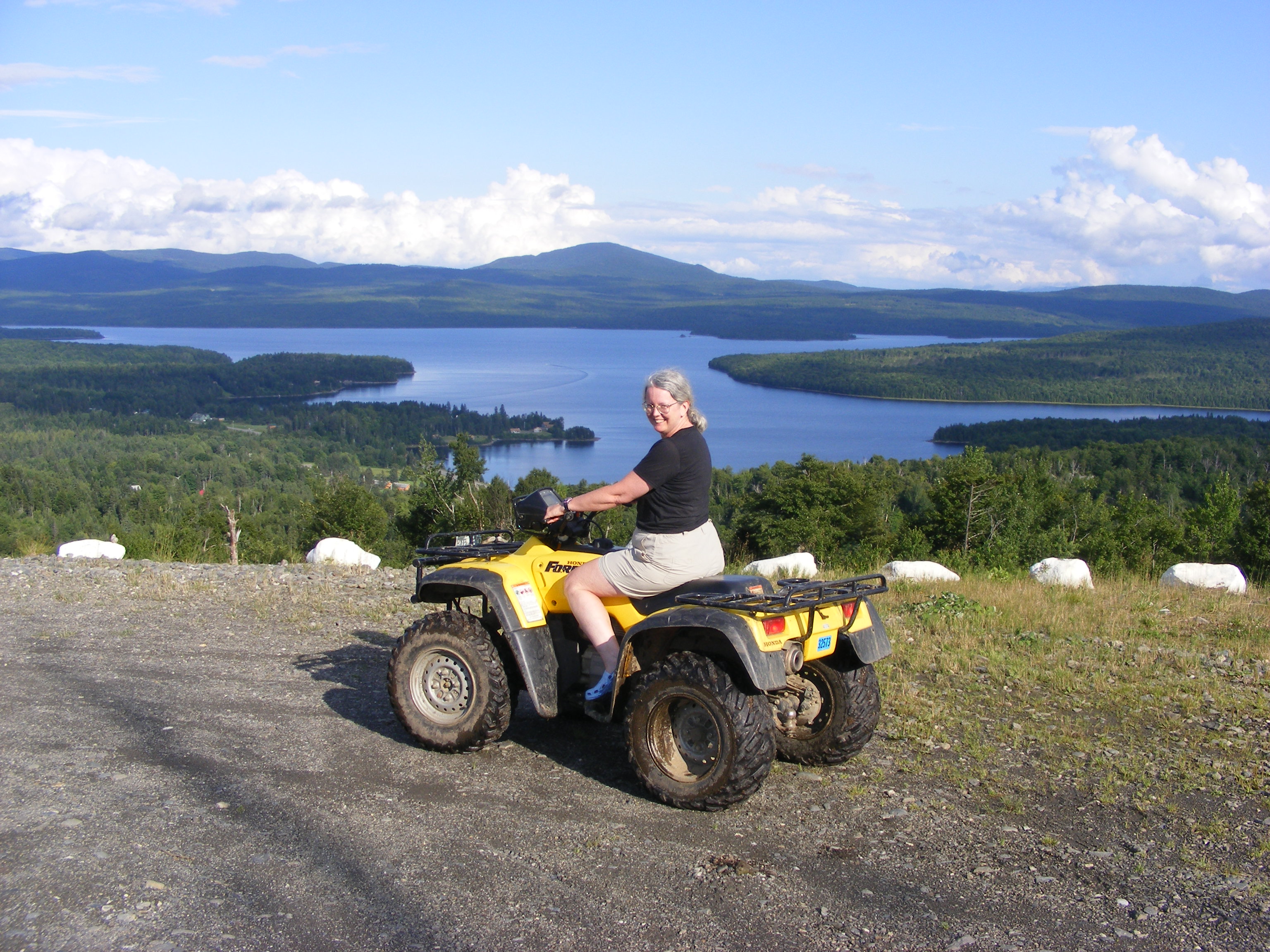
Lainie offered me a ride on her ATV to the top of Prospect Mountain with its grand views, and so I added “ATV passenger” to my list of firsts for the trip. The path to the summit is short but steep and muddy. The views on this sunny afternoon were breathtaking, dominated by big First Connecticut Lake. Mt. Magalloway loomed in the distance; I could just make out its fire tower. I was too dazed to take in the names of all the other peaks in sight.
Another CT supporter who’s a local guide has offered us a kayak trip up East Inlet later in the week. I’m delighted. I had planned a hike in that area, but the best way to see it is on the water. I can barely wait.
Now to review the day’s photographs, read for awhile, and get used to the monster bug that is fascinated by the lamp here in the Bungalow. Tourist injury update: at this point, aches & pains & blisters are manageable. Naproxen helps, and so do dry feet and moleskin.