I’ve spent nearly three months hobbling with a knee injury. It was a triumph for me to cover three miles in an hour on the Nashua River Rail Trail this morning.
It’s bone-dry in my area, as in most of New Hampshire. Even so, buds and blossoms are turning up. A week ago, a few sprigs of grass were poking through the dry leaves at trailside. Today, bluets and violets were blossoming, and there’s much more greenery despite the drought. Rain is forecast for later this week – and a day of that should brighten up the trail in earnest.
What’s new in your area? What’s blossoming in spite of the weather?
It’s Saturday, and I walked today another nine miles on a very familiar path. I’m reminded again that I’m no photographer, My pictures, taken on a phone, might seem like generic New Hampshire foliage shots – but each one is of a spot I’ve seen in all seasons for more than a decade now, on unhurried walks like this one.
Unkety Brook, Dunstable MA; osprey nest atop tree at right. All photos by Ellen Kolb
When the Nashua River Rail Trail opened in 2002, an osprey nest was visible from the bridge over Unkety Brook. I look for it every year. It has taken a beating, and after one storm – was it the Halloween snowstorm of 2011? – it looked destroyed. Two springs later, the osprey were back.
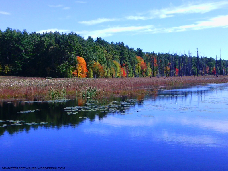
Unkety Brook, Dunstable MA
There’s a farm field bordering Unkety Brook on the north side. Nothing but corn stubble remains from this year’s crop, visible as the whitish ground cover in the center left of the photo above. We had a very dry summer, and Unkety looked low in July and August. The water level looks better heading into fall.
Nashua River Rail Trail, Pepperell MA
The glaring sun reminded me all afternoon that it would have been a good idea to wear a visor. It’s definitely autumn, though: the sun was much lower than at the same hour even a month ago, and it was fleece-pullover weather.
Nashua River, East Pepperell MA
I have an AMC River Guide from 1978, more useful at this point for history than for navigation. About the Nashua River in Pepperell, the writers fretted: “From [Groton] to East Pepperell, the river is not attractive, as the increase in water level has flooded swampland and killed the trees.” Much has changed in 30-plus years, and the area upstream from the dam in Pepperell is now in my opinion the loveliest part of the river.
I headed south of the border into Massachusetts on the Nashua River Rail Trail for a walk through the Groton stretch. Of the four towns along the trail, Groton is where the history of the rail line is most evident. The town is also home to the most park-like section of the trail, situated within the J. Harry Rich State Forest.
The harsh shadows in the photos are from the full midday sun, cheerfully blazing away on a summer day.
The trail crosses over Rt. 119 in Groton on a nicely rehabbed bridge. All photos by Ellen Kolb.
There are three trailheads in Groton, with the most parking available off of Broadmeadow Street. Smaller unpaved lots are at Sand Hill Road and Common Street.
Local students painted the walls of the trail’s underpass at Rt. 225 with scenes of area history.
There are no portajohns along the way. Near the trailhead at Broadmeadow Road are a couple of benches and an informational kiosk. The posted information and illustrations are worth a look.
The best-maintained and most informative kiosk along the NRRT.
Groton must have strict zoning laws that keep commercial signs tiny. How am I supposed to find the nearest place to buy a large iced beverage? That kiosk near Broadmeadow has a bonus: a map of Main Street and the roads connecting it to the trail, with nearby businesses listed. That large iced beverage is only a short walk away.
Marker on Main Street in Groton, a short distance from the trail.
Some of the old rail line’s granite mile markers are still in place, and they’re kept painted by area volunteers. “P” is for Portland, Maine, and “W” is for Worcester, Massachusetts – once upon a time, the two ends of a line of the Boston and Maine Railroad. Of the 120 or so miles of that old line, twelve miles now make up the Nashua River Rail Trail.
“P” is for Portland, Maine, 114 miles from Groton by way of the old Boston & Maine rail line.
Crowning the day was an abundance of Queen Anne’s Lace all along the trail.