East Inlet

2013 update: I’m sorry that Armand, the wonderful guide who accompanied me on the East Inlet expedition, is no longer in the guide business. 

East Inlet, Pittsburg NH.

Seventh in a series of posts from the journal I kept on a 2009 hike on the northern part of the Cohos Trail.

My bungalow room is 85º, if the thermometer on the wall is to be believed. I’m sitting in what is more or less the living room, kitchen windows open, table fan blowing at top speed. I packed for cooler weather. We’re getting 90º days & mid-60º nights. Dew point? Hanged if I know. Sticky weather for sure, and the details are irrelevant. It looks like I have only two nights in my tent coming up. If rain holds off, conditions will be fine.

I am nursing sunburned legs after an unforgettable kayak trip. About me & kayaks: I don’t own one. I rent or borrow one on rare occasions, for use on some nice flat body of water. I avoid embarrassment only by traveling alone. Today, I put aside my reluctance to look like a fool, just because I wanted to see East Inlet from the water, not from a few glimpses off East Inlet Road.

At the East Inlet Road boat launch, my hosts and I put ourselves in Armand’s capable hands. An easygoing man with a dry wit, he knows this area well. He brought a kayak for each of us, so no one was subjected to tandem-kayaking with me. My last experience with a kayak was a few months back when my son and I rented a tandem kayak at Silver Lake state park. I never could manage to find a rhythm, and my poor son endured repeated whacks from my paddle.

I was candid with everyone about my relative inexperience. No matter how awkward or downright wrong my paddling style became, Armand never raised his voice except to call out something encouraging. I suppose that’s what guides are supposed to do, but since I never took a guided trip before, I was relieved not to be taken to task by a stern local with no patience for out-of-towners who can’t paddle a boat properly.

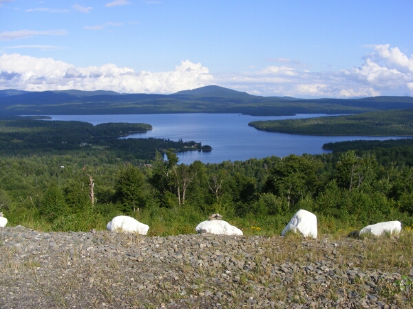
The area we were in has several names, each referring to a specific spot, and I’m not sure which ones we were in: Norton Pool, Moose Pasture, East Inlet. We went across a big pond and then into a narrow stream that wound in what to me seemed like a hopeless maze through the trees. All are beautiful, regardless of name. Eventually, this water all flows into 2nd Lake.

The blazingly sunny day was moderated by a breeze on the water. We paddled out with the wind but against the current, and came home with the current but against the wind. I found paddling upwind to get back across the big pond much easier than trying to push through an opening in a breached beaver dam, against the current. I believe that maneuver took me five minutes, compared to the 10 seconds or so achieved by each of my companions.

My companions had the best free show in town, watching me maneuver clumsily but persistently around the many curves. We had the maze to ourselves. When we first hit the pond on the way back, we saw one kayak after another heading out. Armand remarked that most of the people heading onto the pond would probably not continue into the stream – certainly not as far upstream as we went. Their loss.

I was able to paddle very close to a great blue heron too intent on fishing to pay any attention to me. I saw a bald eagle, huge in comparison to the tiny bird harrying it up in the sky, probably defending her young against the eagle’s depredations. I saw the eagle’s nest. There were many Canada geese that appeared to be unaccustomed to people, unlike the geese back home that have become suburban pests. Cedar waxwings and ducks were abundant.

Kim Nilsen has written in the official CT guidebook about the never-cut stand of black spruce we saw today. Spruce budworm damaged the stand some years ago, but the trees rebounded & this one little area has somehow never been logged.

Perhaps today didn’t count as hiking, but without my CT hike, I never would have found this place or the people who accompanied me. Much of this “hiking” trip, in fact, has been spent doing things other than hiking. I am loving almost all of it. I remain opposed to rainy hikes punctuated with insect stings.

The payment assessed by my hosts for use of the Bungalow is an unspecified monetary donation and/or some trail work. I am going to be donating more than I had originally budgeted. I tried to imagine the bill for everything if this were the “real” world: 5 nights’ lodging, shuttle service, one very important load of laundry. Nothing but the lodging was expected.

I walked to Young’s store today, and they had a pair of padded insoles, which my torn-up feet needed. I snatched them up. When I got back to the Bungalow, I dropped into the swing on the lawn to catch my breath. My hostess returned from errands a few minutes later, and she spied me on the swing. “I have something for you!” she sang out. From her shopping bag, she triumphantly produced a pair of insoles. I burst out laughing. She’s a far more experienced outdoorswoman than I, and she could tell that my blisters were getting the better of me. I accepted the insoles with thanks. Her pair is now in my boots, and I am cutting up the pair I bought to make little doughnut-shaped blister pads.

A fine day, despite my stinging legs. I’m draping my damp laundry over my legs to cool the burn. Sunburn seems a fair price to pay for a day like this.

Day Off

Sixth in a series of posts journaling my hike on the northern section of the Cohos Trail in 2009.

No travel scheduled today. I’m comfortably holed up in the Bungalow on a hot summer day, listening to the Sox game on the radio. My remaining blisters are freshly padded & bandaged. I’ve had time today to look at the field guide on the table in here, trying to identify some of the birds I’ve seen this week. I had a wonderful nap this afternoon, though it cost me a few innings of the game. I’m sorting and re-packing all my things. A lazy day, though not a wasted one.

The remainder of my trip is firming up. Tomorrow, we have our kayak trip. Saturday is Old Home Day down in the village. I’ll catch a ride down there. Weather should be pushing 90 degrees, with no rain forecast for the weekend. The next day, I’ll hike to Deer Mountain SP, where I’ll stay for two nights. I’ll hike to the Canadian border & 4th Connecticut Lake one of those days. Next Tuesday, there will be a press conference just over the border to celebrate the linking of the CT with the trail network of Sentiers Frontaliers (SF), a hiking group from Quebec’s Eastern Townships. I’ve arranged a ride to Pittsburg village afterward, where I have a place reserved for Tuesday night. Wednesday, if the weather’s good, I’ll get back to Sportsman’s Lodge in one long haul, walking on Rt. 145 & Creampoke Road instead of the CT. Less favorable conditions will result in a break at Rudy’s. Either way, I’ll be finished ahead of my original schedule.

While I’m in the village, I’ll mail home my tent & sleeping pad & whatever else I don’t need to carry once I’m done camping. A light pack will help me get to Sportsman’s in one day, as will sticking to town roads (longer route but smoother path). Light load + good weather = excessive optimism.

This is all sounding manageable. Setting my own pace (slow) and schedule (flexible) has worked.

Trail Work & Road Trip

Summertime’s blue asters abound along the Cohos Trail.

Fifth in a series of posts journaling my 2009 hike on the northernmost section of the Cohos Trail.

The trouble with full days is that I get tired in the evenings when it’s time to record the day’s events. Not a bad problem to have. Today was tiring, but in total, quite satisfactory. My aching body is aching less, which is encouraging.

Today, I worked on a new segment of the CT, which we all hope can soon be formally dedicated. I was with Lainie Castine, practically a legend among Cohos Trail builders. We started at Round Pond, where the proposed Round Pond Brook trail begins winding its way to US Rt. 3. As of now, the CT is on US 3 from River Rd. in Pittsburg to the Quebec border. Alternate routes & spurs are slowly being designed & approved, and will be developed piecemeal. The RPB trail was flagged by CT volunteers last spring, and state approval is pending, with a walk-through by a state official needed eventually.

Lainie handed me a pair of loppers & told me to follow her & look for flagging tape. Within 10 minutes, she realized that someone had come through & reflagged the trail on a slightly deviated route. Her GPS was only slightly helpful, but our compasses sure came in handy. I did very little lopping, but I helped get the trail’s flags back where they belonged.

A problem that became obvious — far more obvious on the Camp Otter Trail, where we worked in the afternoon – is that the flagging earlier in the year was done in the spring, before summer grasses grew several feet high. Some trail routes along snowmobile trails looked just lovely 4 months ago. Now, it’s midsummer. Grasses & ferns & the aptly-named hobblebush have grown several feet high. The snowmobile clubs won’t be working on the trails again until fall. The routes we checked today would pose a maintenance nightmare. Not an insoluble problem, to be sure, but a challenge.

We were on game trails when we weren’t on snowmobile trails. I saw a bobcat track for the first time. We saw plenty of moose tracks, as well as a spot in the Camp Otter area that’s obviously used by moose as a place to bed down. Bears left the most traces, though: prints, scat, more scat.

Coming out of the woods on the Round Pond Brook trail, before we got to US 3, we came upon a field full of Joe-Pye Weed and bee balm. This area is bursting with summer blossoms.

Camp Otter was an arduous couple of miles of slogging through mud & stumbling over long, tangled vegetation. This is the area where the trail association wants to put in 500′ of badly-needed bog bridging. I’m told that the materials have been acquired but are being stored down in Stark.

Rain began as we started to whack our way through the vegetation along Camp Otter trail. We were already so muddy that we didn’t care. Lainie is fine company, and she is undeterred by such minor matters as mud! Her attitude was contagious. She fed waypoints into her GPS, reflecting the improved trail route we flagged today. I became the first non-CT-board member to hike these segments. With breaks, it took us about 5 hours to walk/bushwhack/slog 4.1 miles. We felt like very wet pioneers when we were done.

We really were filthy by the time we were shuttled back to the Bungalow. Lainie insisted that I get first crack at the shower, and she  was kind enough to put my muddy clothes along with hers right into her washing machine. Once I was cleaned up, I made a double batch of mac & cheese for a late lunch, and that simple little dish was perfect.

As I ate, I thought about some of the things I had planned to do on this trip. After only a couple of days with blisters, I had to admit to myself that Mt. Magalloway is out. I lost it the moment I dunked my feet in the mud on the Lake Francis trail and then didn’t dry them promptly. A steep uphill walk would be torture at this point, leaving me unfit for the other walking I need to do.  There are already unexpected delights on this trip, though, in areas to which I could never have dayhiked from here.

Later, with my laundry hanging to dry, my hosts proposed a ride — “bring your camera!” We piled into their beat-up but valiant truck, and off we went.

First stop, Young’s, where everyone had things to pick up. Second stop: Moose Alley Cones, where I reveled quite messily in a double scoop of chocolate moose-tracks ice cream. Good thing I’d bought paper towels at Young’s. This ice cream stand had been on my to-do list for the trip, and I hadn’t told anyone about it, so this was an auspicious start to the road trip.

We proceeded north on US 3, the “Moose Alley” of all the tourist literature. We stopped at 2nd Connecticut Lake, at the boat ramp off the highway. We were the only people there. Once out of the car, I looked around in awe, overcome by profound silence. We were away from the dam at the lake’s south end, so there was no sound of rushing water. At that moment, there was no bird’s song or call, though I’m told loons are frequently seen here. No aircraft overhead, no carloads of tourists, no boats or boat motors – a place & a moment of peace, with nothing in view but the lake & the spruce trees all around.

From there, we drove north a couple of miles to Deer Mountain State Park, a campground with 20-some-odd sites. This gave me a chance to scout my quarters for next Sunday & Monday nights. Pleasant spot, lots of trees, Connecticut River the size of a brook rushing down a stretch called Moose Flowage: all good. The attendant lives on-site; we’re way beyond commuter territory. There’s no rec building or any other community structure. About a third of the sites were occupied, which confirmed my hope that a reservation & its fee would be unnecessary. I love the signs I’ve seen at all three state parks on this trip: “If office is closed, occupy any available site” – and leave the fee at the iron ranger, of course. Lots of honor-system operations up this way. As I expected, there’s no electricity at the park. In fact, we’d left the last US utility lines behind us a few miles back. (Our border station relies on Canadian utilities.) The park also has no water supply aside from a single spring, piped up at a spot near the entrance.

Notes made & photos taken, I hopped back in the truck. We headed back south past 2nd Lake & turned east onto Magalloway Road. I noticed mile markers, and it turned out that all the back roads we were on last night had them. I suppose they’re useful, as long as you don’t expect to use a cell phone to summon help to your broken-down car at mile marker 3 on Magalloway Road. There is no, I mean NO, cell signal there.

These back roads, originally created by logging companies & still maintained in part by them, cut right through thick, thick woods. Spruce predominates. “Great North Woods” is no mere chamber of commerce conceit. We passed a number of small logging cuts that hardly put a dent in anything. The spruce all looked nearly black as the sun began to set.

At a fork we headed right, to Buckhorn Road. There were camps here & there, most of them looking neat & maintained despite the absence of cars in the driveways. The sky to our right was beginning to take on beautiful tints & tones in the last of the day’s light.

Another turn put us on Cedar Stream Road – the same Cedar Stream Road I’d found so boring a few days ago. We were miles farther east, though, at mile marker 19. This stretch was wilder, with fewer camps, and still no moose. We drove westward, & the full glory of the sunset was right in front of us. I could afford to enjoy it; I wasn’t the one who had to drive into the glare.

At the intersection where I had veered off to the Bog Branch bridge & the Lake Francis trail a few days ago, we turned left onto the east end of the nine-mile-long Deadwater Loop Road. This was the Wild America stretch, seen by very few flatlanders like me. This would have made a more interesting hike than Cedar Stream Road, coming from Rudy’s. I’ll remember that the next time I’m up this way.

Approaching the village, we turned onto Cedar Stream Road again, then Rt. 145 and then US 3. We drove onto giant Murphy Dam – giant for these parts, anyway. Pete told me this is an earthen dam, built in the 1930s.

Back on US 3, we passed the Pittsburg high school. I’m going to get a picture of the building on Old Home Day next weekend so I can show my son the home of the class S baseball champs. Their tournament victory made the front page of my downstate newspaper a few weeks back — a high school of 37 kids, with 14 of them on the team.

(As I write this, a small plane is passing overhead. That’s unusual here.)

The evening ride’s last leg was around Back Lake, ringed with inns and resorts. As we returned to Danforth Road after three  unforgettable but mooseless hours, I said it would be funny if we drove over 40 miles & didn’t see a moose until 200 yards before the driveway. I was off by just a bit. On the way up Danforth, there was our one & only moose, waiting for us as if hired. Our tour was complete.

A Much Better Day

Fourth in series of posts journaling my 2009 hike on the northern section of the Cohos Trail.

Since this trip in 2009, the exceptional hosts about whom I write below have gone their separate ways, and there’s no longer a Mountain Bungalow. See cohostrail.org for information on places to stay.

First Connecticut Lake and Mount Magalloway, Pittsburg NH

Sun came out 9-ish this morning, so I had a chance to spread out the tent fly and backpack to dry. In the hour before things clouded up again, I enjoyed a walk along the lake shore before I came back to pack up my gear. I blessed every one of those little plastic bags as I re-packed them into the backpack. Dry gear and a bit of sunshine did wonders for me.

I made a mental note of things to do differently if I’m ever possessed to to this again: get a lighter tent; bring fewer clothes for a midsummer hike; find useful rain gear; no more sleeping pads from Target. Pony up the big bucks for a light-but-cushy pad.

Today’s short hike brought me to the Mountain Bungalow, on the property of two Cohos Trail board members. The Bungalow is going to be my home for a few days while I do some trail maintenance with Lainie and play tourist in Pittsburg. I’ve lived in NH for over 25 years, but northern Coos County is unfamiliar to me, and I want to see as much of it as I can while I’m here.

The walk up River Road to Rt. 3, with a little shortcut marked with a CT sign, leads to what the map calls Happy Corner. What’s so happy about it? Check this out: Young’s store, a great little restaurant, and a covered bridge, all right there. (Oh, all right, I actually had to walk for 5 minutes to find the covered bridge. Don’t be picky.)

Young’s had the camp shoes I hoped for, lightweight & cheap. The Happy Corner Cafe next door served me a splendid lunch. Let me recommend the Corner Burger, piled with cheese, onions, mushrooms, & green peppers. Two tables over sat the family that camped at the site next to mine last night.

I headed up Danforth Road in a light drizzle, along the south slope of Prospect Mountain. (New Hampshire is littered with Prospect Mountains, I think, but this is the only one near Happy Corner.) It’s an uphill walk, but no killer. The bungalow was at the end of the road, a bit shy of the summit. Two moose, cow & calf, crossed the road ahead of me as I made my way up, but they were gone before I got my camera out. I was later told that I was lucky; moose are apparently an unusual sight on that road.

I knew I’d found the right place when I got to a sign proclaiming “Northern Headquarters of the Cohos Trail.” By the time I got there, the sun was out, and we had a gorgeous afternoon. My hosts gave me a friendly greeting and showed me to the Bungalow. I have the whole place to myself; it can accommodate up to six people. No running water, but there are plenty of jugs I can fill from the main house. There is electricity. There’s a radio, and I’ll check out the reception eventually. The kitchen is tiny but certainly adequate. This all reflects a lot of work & care by my hosts.

A cache that I had mailed a week ago awaited me. It has a few days’ food for my expected 4- or 5-night stay at the Bungalow. Once I emptied the cache box of its contents, I started filling it with things from my pack that I’ve already decided I can live without. Must lighten pack.

I put on my new camp shoes as soon as I got here. My boots will now dry out from their dunking in the bog yesterday. My blisters, every ugly swelling one of them, get TLC by not being jammed back into damp shoes. Aside from the boots, everything has dried out from the bog & the rain.

One of my hosts offered me a ride on her ATV to the top of Prospect Mountain with its grand views, and so I added “ATV passenger” to my list of firsts for the trip. No helmet. (I’m in a land of people with a particularly jaundiced view of government regulations.)  The path from the Bungalow to the summit is short but steep and muddy. The views on this sunny afternoon were breathtaking, dominated by big 1st Connecticut Lake just below. Mt. Magalloway loomed in the distance; I could just make out its fire tower. I was too dazed to take in the names of all the other peaks in sight. I took photos galore.

Another Cohos Trail board member who’s a local guide has offered us a kayak trip up East Inlet later in the week. I’m delighted. I had planned a hike in that area, but the best way to see it is on the water. I can barely wait.

Now to review the day’s photographs, read for awhile, and get used to the monster bug that is fascinated by the lamp here in the Bungalow. Tourist injury update: at this point, aches & pains & blisters are manageable. Naproxen helps, and so do dry feet and moleskin.

Rain, blisters, & bites

Lake Francis, Pittsburg NH

Third in a series of posts journaling my 2009 hike on the northern section of the Cohos Trail.

Yesterday was not fun. It stopped short of being miserable, but I’m still glad to be past it. I now have even more respect than before for the folks who set out in June to through-hike the CT and were stopped within days by that month’s relentless downpours. I started whining to myself after only a few hours of rain. Not even thunderstorms, mind you — just rain. Gotta toughen up a bit.

I started the day feeling fine after a very good night’s sleep. A day-long hike is a great sleep-inducer. My first sight as I looked out the window this morning was a loon on Clarksville Pond, silently wishing me good morning.

I might have covered anywhere from 13 to 15 miles today, but it’s impossible for me to tell since the CT map doesn’t reflect the recent re-route through the Deadwater area. I was on the trail 8 hours, including stops for snacks & navigation & one maddening half-hour lost at a confusing intersection. The compass was handy.

I have blisters now. Oh, do I have blisters. I chose not to pack light shoes for camp in order to save space & weight. Bad move.

At least the rain held off for the first 3 hours or so of the day’s hike. Let me state firmly that I hate snowmobile corridor 21, on which the CT now travels for a few miles. Finding it was a cinch. Walking on it was a real pain. There are very few CT blazes, since the trail is “so easy to follow,” according to the CT website. Hmmm.

First big intersection: well-worn dirt road to left. Smaller trail to right. Little CT sign pointing (not facing northbound traffic, by the way) down the smaller trail. I stopped & brought out the compass, knowing that I ought to be heading north. Great: north was precisely between the two trails. I decided to pick one, walk 10 minutes, and if I found no CT sign, back up & try the other trail. Ten minutes brought me to one snowmobile sign, but no CT sign. I backtracked & walked down the larger road, which led to a logging yard & a gate. At least that only took 6 minutes (one way) to ascertain. OK, back to the smaller trail, corridor 21.

I couldn’t expect blazes on trees, with ditches on both sides of the trail. I hoped for a little brown CT sign, though. No such luck. The trail narrowed and became quite overgrown. I was heading in a northerly direction, there were no junctions, & the ridge running parallel to the trail to the east corresponded to a ridge on the map. Corridor 21 was really the only game in town.

Further on, still more weeds, & OUCH! I was hit by two simultaneous sudden attacks – a bee sting on my finger, and a sting or bite on my leg, clear through my sock, that I think must have come from a surprised & angry little garter snake. Are-we-there-yet came to mind, and not for the last time.

At last, Deadwater Loop Road. Go right or left – about 7 miles to the east end of Lake Francis in either case. I went left, hoping to hit Cedar Stream Road along the lake’s south shore within a couple of miles. Five minutes later, the rain started. I had packed most of my items within the backpack in sealed plastic bags, and that proved to be the smartest bit of preparation I’ve done. Neither a poncho nor a plastic garbage bag proved adequate today for covering me AND my pack.

Cedar Stream Road is wide & flat, but views of the lake are mostly obstructed by trees & camps. There was no place to rest other than the ground. Rain continued off and on.

There was a little CT sign at the junction where the CT goes off Cedar Stream Road & picks up the Lake Francis Trail. I knew from the CT website that this boggy & soggy trail had been weed-whacked just a week ago, and I thank the trail volunteers for that much! A pox on any & all ATVers who have come through, turning every little brook & drainage into a quagmire. [2013 update: my attitude towards ATVers has mellowed considerably. It’s worth noting that in June 2013, a Coos County group called Ride the Wilds was established to link 1000 miles of northern NH trails.] At one point, the inevitable happened: one mud puddle couldn’t be skirted, & it was deeper than my boots. Boots, socks, feet – all wet. (No gaiters.) I knew then that blisters would form & intensify within minutes. Sun was out by then, although I was under such a thick canopy of trees on this trail that rain might not have been a problem.

The CT databook I carried said “keep left @ all junctions.” Junctions?? The only one I saw was a signed snowmobile intersection, where I obediently went left. Are-we-there-yet was absolutely consuming me. The wobbly knees were back by this time. The sweetest sound of the day: an internal combustion engine somewhere ahead of me, confirming that there was a road nearby. (I knew that I was parallel to River Road, but bushwhacking wouldn’t have helped – the Connecticut River was in the way.)

At last! A road, a bridge, & a left turn put me on River Road. I’d have kissed the ground, but that would have meant getting up with the pack dragging me down.

Straight shot, about a mile, and I was at Lake Francis State Park & my little tent platform. I checked in & found my spot. Clouds were building again, so I pitched my tent right away, improvising long guy lines to accommodate the tent platform. Then, in order: ice cream from the park store, a shower, & a load of laundry. While the laundry was in the dryer, I used the pay phone to call home & check in. My husband knows not to worry, but my teenagers made clear to me before I left home that I was to call whenever I could. Now they know how I feel when they’re out somewhere! Good to hear their voices, as always.

There’s a loon calling nearby as I write this. My campsite is just a few trees away from the lake, away from the RVs, & I have civilized neighbors – a tranquil setting.

Rain resumed early in the evening, by which time I had everything buttoned up for the night. A neighbor came by with his dog to invite me to wait out the rain with his family under their screened canopy. Nice people. I declined, though, & I was in my sleeping bag moments later for what turned out to be 12 straight hours of sleep. My inexpensive little tent did NOT leak.

There’s that loon again. I’ll always associate that eerie cry with tranquility.

On Taming the Backpack

Loon on Clarksville Pond

Second in a series of posts journaling my 2009 hike on the northern section of the Cohos Trail.

This is the first full day of moving under my own power for this trip. No cars, no one to bail me out. This is worth noting only because this is the beginning of my first hiking trip lasting more than two days. Thus I celebrate turning 50. Here’s where I find out if my months of preparation were at all helpful.

From Sportsman’s Lodge, I picked up the CT northbound and headed to Rudy’s Cabins & Campground in Clarksville. I called manager Kathleen a couple of weeks ago to ask about a tent site. She confirmed that she had some, but she quickly added “the weather can be nasty, & there’s no bathhouse.” She told me a vacant camp (meaning cabin) was available for the night at a very reasonable rate. Sounded good to me. I’ll have other nights to use my tent.

The trip from the lodge to Rudy’s amounted to a 6 ½ hour walk, which included several short stops for snacks & water, 10 minutes of befuddlement at one intersection, & 3 very long minutes backtracking to find the map & databook which had fallen out of my pocket. I had sunshine for all of it. Most of the miles were on town roads & well-defined snowmobile trails.

I started the day with a fine breakfast at the lodge.  I am REAL glad I started the day with that; turns out I needed it. I delayed my departure until 7:45, right after channel 9’s forecast for a sunny day. I shouldered my heavy pack (30 pounds, feels like 40, wish it were 20), fastened a small bag with camera & snacks around my waist, took up my trekking pole, and was off.

An inauspicious start: I barely made it up the driveway. That little uphill slope felt like a mountain to me with that pack. I stopped at the mailbox & tweaked the pack straps to try to get more comfortable. I did that three more times in the first quarter mile. Finally I decided to stop at Coleman & remove the pack for serious adjustments. I found that one side of the sternum strap was misthreaded, and that was a quick fix. It took me a bit longer to adjust the shoulder straps to put the padding where I needed it most. Five minutes later, with the pack sitting more comfortably, I continued on my way.

Any experienced backpacker could have seen that problem coming. I didn’t. For all the hiking I did in preparation for this trip, I didn’t do any of it with a serious amount of weight in my pack. Mistake. I’m very glad I’m not on the mountainous part of the CT. I wouldn’t have been able to manage this load on a serious hill. Today’s travel was mostly along easy town roads, with the last few miles on snowmobile trails.

Heath Road was signed & easy to find. It’s a two-lane-wide dirt road, narrowing after a little bridge to maybe a lane & a half, but definitely a maintained road (though a sign warned that the road was “class V”, maintained only between May & December). I kept the CT map handy, but I was sure I could count on road signs.

Well, for awhile, I couldn’t. I came to an intersection at a farm, with a little gated lane to the right. Map showed a turn at a gated lane by a farm. I turned up the lane, & found that the gate was festooned with no fewer than four No Trespassing signs. I looked carefully for a CT blaze & saw none. I was extremely reluctant to ignore the signs, for two reasons. First, I had no desire to spend any time being dragged down to the state police in Colebrook. (Stewartstown does not boast a police department, & according to Mrs. C, thereby hangs a tale – but I digress.) I’m sure I’m not carrying enough cash for bail or a fine or whatever else they extract from trespassers around here. Second, and decisively, I know that the CT Association has spent years working with landowners, trying to get easements & permissions. It’s a delicate business. One angry landowner could set trail development back five years.

Hooray for timidity & prudence. A few more minutes on Heath Road brought me to the intersection I sought, complete with – yes! — real town-maintained street signs. Bear Rock Road was much livelier than Heath, meaning about 7 cars passed me. Each driver gave me a cheerful wave. Bear Rock is a pleasant road, but not a shady one. I was glad to have sunscreen & a hat.

Flat town roads are all well & good, and certainly better suited to my experience & temperament than mountains, but I knew “flat” couldn’t last. The day’s aerobic workout began on Macallaster Road. That’s where I found the farm-and-gate referred to on the map. I stopped for a few minutes for a snack, and found to my amazement that my cell phone was picking up a faint signal. I texted an I’m-OK message to my daughter back home, and she texted me right back. That, I suspect, is the last communication I’ll be doing via cell this week. The phone’s main usefulness from here on out will be as an alarm clock & contact list.

The snack was plenty. I found I didn’t want a huge lunch. It probably would have made me drowsy. Quick snacks and water stops got me through the day, although I got tired of swinging my pack off to refill my small water bottle. For tomorrow, I’ll rig an easy-to-reach strap for the quart-size Gatorade bottle that serves as my main reservoir.

My trekking pole earned its keep today. I’ve avoided it for most of my hikes in the past. One stiff knee and one persistent case of plantar fasciitis in recent months have persuaded me that I need one. It made my morning hike easier and my afternoon hike possible.

Three cars in caravan came down Macallaster at one point, one of them trailing the acrid odor of overworked brake pads. This drove home to me the fact that whoever put those contour lines on the map wasn’t kidding. I got smiles & waves from the drivers, with encouraging words thrown in. Pressing onward uphill, with breathing & pulse becoming more labored, I told myself that I used to pay Gold’s Gym to move me to workouts like this. I never had such pleasant views on a treadmill, though. There were green hills all ’round, near & far, sunshine pouring down on everything.

I was struck, as I was yesterday, by the variety & vigor of all the wildflowers on the roadside. This area can have very inhospitable weather & it certainly has a short growing season. No matter: the wildflowers, no doubt considered weeds, are running riot here. They’re no less beautiful for being common.

Eventually I passed Creampoke Road – I love that name – and saw quite a camp there. A hybrid mobile-home/permanent structure was occupied today by two or three generations of a family having a good visit. A little dog barked at me fiercely, bringing my presence to everyone’s attention. Who should be part of the gathering but one of the women who had driven past me an hour or so before! “You’re making good time,” she exclaimed, and asked me where I was headed. I told her I was going to Rudy’s for the night. Everyone around here knows about Rudy’s Cabins, apparently. The family wished me well.

I turned onto Haines, a rough “class VI” road that gets no town maintenance. Shortly, a bicyclist came into view. I called out to him that he was doing the real work, pedaling on gravel. He asked me if I was doing the CT & was pleased with my answer. He gave me an update on conditions up ahead. Within a couple of minutes, we both realized that we had met at last June’s gathering of CT supporters. I was glad to have his good cheer & encouragement as fatigue began to set in.

CT blazes were handy as the road petered out to a snowmobile trail. I made my left turn at Weirs Tree Farm, just as map & databook directed. There was a scene that stopped me in my tracks: a clear view to the north, hills & mountains a-plenty. The Connecticut Lakes were out there somewhere, concealed by ridges.

At this point, I had to lean heavily on my trekking pole with each step. Just two miles to go – and I’m glad it wasn’t three. I was tired, and I knew the signs: wobbly knees, near-inability to look up since I had to concentrate on where I was placing my feet, repeated sharp jolts to my knee as I stumbled. This is how a person gets hurt on a hike. So much for my “training”! Getting to Rudy’s put some heart back into me.

A re-route last May took the CT a mile or so away from Rudy’s. The short walk away from the trail was absolutely worth it. The camp that owner Kathleen had reserved for me looked ready to fall down, but then I went inside. It was just fine! Comfortable, snug, electricity & running water, and situated right on Clarksville Pond: an altogether acceptable alternative to a night in a tent. I went to the campground’s office to pay for my night’s stay and to thank Kathleen, but she wasn’t there. I tucked my payment & a note into the office.

First thing I did at the cabin was take my boots off. (Ahhhhhh.) Second thing was sit on the porch & relax. I heard a low thrum & quickly looked up – and there was a hummingbird, barely a foot & a half from my face. I barely had time to register the amazing sight before it flew away. Plenty of birds are here along the shore.

So it’s a happy end to my first long day. I am content. I had hoped to get some sunset photos, but it’s cloudy — all shades of gray. Pretty, in its way.